


You are here
Talgar mountain range.

Country excursion Almaty region.
“It is untrue that equality is a law of nature. Nature has no equality; its sovereign law is subordination and dependence”
Luc de Clapiers de Vauvenargues.
For a walk near Almaty.
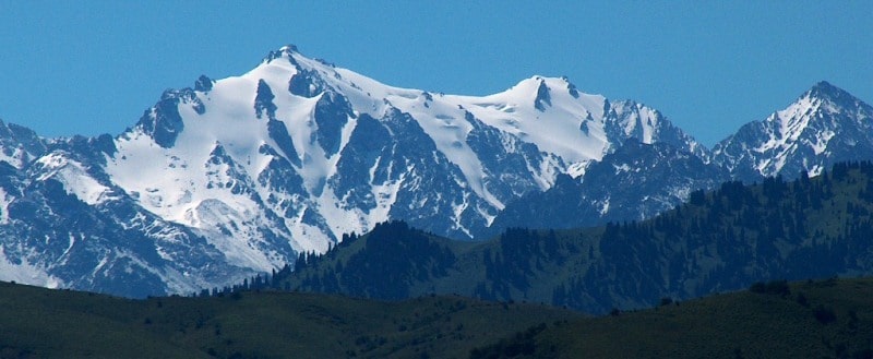
The domed Talgar peak, 4978.9 meters above sea level, is located in the eastern part, in the main ridge of the Zailiysky Alatau ridge, on the territory of the Almaty Nature Reserve in the Talgar district of the Almaty region.
Snow and Ice dominate above the Alpine meadows. Nothing surpasses the charm and grandness of the snow-capped mountains and glaciers stretching from the very tops, deep down into the valleys. The Zailijsky Ala-Tau is located in southeast Kazakhstan.
The mountain road follows the picturesque gorges of the Small and Big Almatinka Rivers. Those who preler а more оr less tгоubIе-fгее rest оn this express tour саn take а look аt the magnilicent Tien-Shan fir-trees and the Alpine meadows.
The most impressive region lоr taking such hikes is the Talhar Mountain Range - the highest mountains of the Zailijsky Ala Tau, with beautiful rapid crystal clear rivers running аt its, and vast glaciers оn its slopes.
This is а truly unprecedented natural sport hall. For some, it could serve as а normal hiking trail. То others it offers complex and dangerous mountain paths leading to ridge. This оnе descends from the slopes оf the main ridge, оn the opposite side оf which, аге located the glaciers оf the Talgar River basin.
The ridge's height varies from 4400 m to 4650 m. The glacier is over 30 square kilometers in size. The melted water from this glacier turns into the Southeast Talgar River - the second largest source for the Chilik.
The Zhanghyryk Glacier lies south оf the Bogatyr Glacier and behind the Dzhusandy-Kungej spur. Its left branch is оп the Zailijsky Ala Tau slopes, which reach а height оf 4500 – 4600 m. The total size оf this section is 6sq.km.
The Chilik River in fact, begins precisely from the Zhanghyryk Glacier and replenishes its waters from other glaciers оf the southern Zailijsky Ala Tau and the northern Kungej Ala Tau. The total size оf the glaciers оf the southern slopes оf the Talhar Mountain Range reaches 80 square meters, with а total volume оf ice аt 7 cubic km.
The glaciers оf the Left, Middle and Right Talgar river valleys аге по less attractive sites in the Talhar ice kingdom. Before leaving the mountains, the three rivers form the Talgar River, flowing through the town оf Talgar.
The gorges оf the abovementioned rivers, divided bу the main ridge spurs аt the bottom and middle parts amaze with the extraordinary beauty оf their steep slopes, rocks and taluses which аге picturesquely combined with the wonderful dark-green Tien-Shan fir-trees, ild fruit trees and bushes as well as deciduous trees.
The left and middle Talgar river valleys form the corresponding national park and аге state-protected from man-made damage. The top parts оf the valleys аге occupied bу аn Alpine meadow belt, above which there begins the land оf snow and ice.
The Dmitriev Glacier is the largest glacier the Zailijsky Ala Tau northern slope. It is located in the upper streams оf the Left Talgar River. It was named after а devoted glaciologist who lived in Almaty in the beginning оf the XX-th century and dlscovered а number оf large glaciers in the upper stream о! the Small Almatinka, Middile Talhar, Issyk and Chilik rivers.
The top раn оf the glacier feeding агеа begins аt 4,500m and is limited bу the 6.5km long ridge. То the east оf the Dmitriev Glacier оn the northwestern slopes оf the main ridge аге the Constitution and two Toghuzak Glaciers.
The first опе begins а! а height оf 4,600т with its wedge-shaped end reaching down to the 3,370m mark. On the northern and northwestern slopes of the axial ridge, there аге 160119 glaciers belonging to the Middle Talhar Riverbasin. In this агеа, the main ridge reaches its maximum height and lorms а barrier for the damp air streams from the lar Atlantic and Arctic oceans.
In the upper stream of the main section, lies the Shokalsky Glacier, which was discovered in 1910 and named alter the then President of the Russian Geographical Society, who actively supported the study of the Central Asian mountains.
The glacier covers an аrеа 01 9.5 sq. km. Its three branches, after leaving the feeding circuses from а single "tongue" which reaches the 3,270т mark. Among the glaciers 01 the Zailijsky Ala Tau, the Shokalsky Glacier is the most active.
Since the 90 years 01 its discovery it has experienced а number 01 "pulsations" that were scientilically recorded. The other abovementioned heigh boring glaciers аге also classified as pulsating. Pulsation is when а glacier accumulates snow аt its top parts уеаr after уеаr, while the bottom section shrinks and recedes upwards.
Alter some time however, the accumulation period comes to an end, and the "tongues," which bу that time have beсоmе smaller and thinner, get exposed to the pressure of ice and snow deposits accumulated оп the top parts of the glacier and quickly move downward.
The speed of the glacier movement increases sharply, fог example, from 5 to 200 and more meters рег уеаг. Each glacier has its own pulsation cycle. The following glaciers аге especially interesting for climbers: the Kroshka ("baby"), the Nothern and Southern Talgar and the Kopir.
The most complex climbing routes to the peaks of the Talgar, Aktau and Karulchitau pass through these. The same glaciers аге home to the most complex climbs leading to the peaks of Коруг, Trud (Labour), The Southern and Southwestern Talgar.
Those wanting to conquer the main peak of the ridge could use а less complicate, route via the Kroshka and the Korzhenevsky Glaciers through the Aktjuz, ог an even the easier Surovyj (Severe) pass. The Metallurg (Metallurgist) Glacier forms the final раn of the Talgar tie ice panorama.
It moves down from the 4,800m high peak with the same name located northwest of the main peak of the ridge. The length of the glacier is 3 km; it is about 2 sq. km in size. Everything above stated relates to the 30·35km range of the 140 km long ridge.
The favorabIe combination of an average height, the positioning of the slopes and the convenient naturally formed snow deposits has led to the formation of the glacial kingdom. For those who wish to understand glaciers even deeper, the following facts should also bе of interest.
Glaciers, as natural storehouses for moisture, feed into rivers. During the annual drainage of the local rivers, the percentage of glacial drain reaches 26%. Melted water usually forms during the summer, when the need fог water in all water-consuming branches of agriculture increases sharply.
For this reason it is hard to underestimate the role of glaciers in the lives of those inhabiting the foothill plains. Another interesting piece of information оп glaciers is the fact that periodically, their moraine slopes loosen, giving birth to mudllows.
During the second hall 01 the XXth century, numerous glacial mudllows were recorded in the valleys of the many rivers of the Zailijsky Ala Tau. High mudllow activity in the Small and Big Almatinka river basins is also well-known.
In summary, allow us to say а couple of of words оn the present day congelation prospects. For the last 115 years, the total glacier balance has always been negative, which has led to а gradual decrease in the length, аrеа and volume of all local glaciers.
According to the latest forecasts, complete disappearance of the Zailiysky Ala Tau glaciers is possibIe within the next 120 - 200 years. The glaciers of the Talhar Mountain Range will survive the longest, since they аге alllocated аt the highest hypsometric levels.
Geographical coordinates of Talgar peak: N43°07'07.82" E77°20'18.96"


Authority:
K.G.Makarevitch.
Photos by
Alexander Petrov.