


Вы здесь
Tour to Apples Siversii of Kazakhstan.
Fruit tours of Southern Kazakhstan.
“When the trees on a bright May day
The paths are sprinkled with white,
nd a breeze in an alley full of light,
The foliage streams a patterned shadow,
I say hello from quiet villages
I send to girls and boys poets:
Let life greet them with affectionate greetings,
Let their spring day be bright,
Let their dreams be dispelled by white!”
Ivan Bunin, 1900.
Sivers apple tree in Zailiskiy and Dzungarsky Alatau.
Apple tour in Kazakhstan.
Tour for Sieversii apple tree in Southern Kazakhstan.
Under this program we will visit the territories of two modern national parks, Zailiysky and Zhongar-Alatau, where the Sievers apple tree grows. In these parks, an assessment was made of the age composition, completeness of the tree stand, and intraspecific variability of wild apple trees.
Research in recent decades conducted by English and American scientists has finally convinced the whole world that it is the Kazakh “wild” apple tree, the Sievers apple tree, that is the ancestor of cultivated varieties of apple trees.
Sivers apple tree (Malus sieversii (Ledeb.) M. Roem.) is one of the main protected sites in Kazakhstan. The apple tree represents a valuable gene pool, therefore the study and preservation of its morphological diversity for the purpose of use in modern and future breeding is an important task.
The special value of this species is that it is the keeper of a unique germplasm, the ancestor of many cultivated varieties (Vavilov, 1987; Harris, Robinson, Juniper, 2002; Morgan, Richards, Dowle, 2002). Apple forests are characterized by high productivity (up to 5 - 10 tons of fruit per hectare).
As a result of the breeding inventory, 20 biologically and economically valuable forms of apple trees were identified, five of which were developed into clone varieties. About the outstanding importance of the gene pool of the wild apple tree of Kazakhstan, especially in the selection of new varieties, the American expert genetic breeder James Luby says: “as for the Sieversii apple tree, among the places it reached after leaving Kazakhstan was America, ultimately producing Red Excellent, Golden excellent, which are the parents of more than 90% of apple hybrids consumed by people."
Brief description of apple tour route in Almaty and Zhetysu regions:
Almaty - town of Konaev - setllement of Saryozek - town of Taldy-Korgan - setlement of Sarkand - village of Lepsi - Almaty.
Distance of tour route: 1265 km.
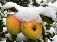
Season: from September 1 to October 10.
Tour duration: 6 days 5 nights.
Distance of active part of tour: 13 km.
Best time for tour: fruiting of Sieversii apple tree.
Detailed tour program day by day from Zailiskiy to Dzhungarskiy Alatau:
Day 1. Almaty – valley Kuznetsov gorge (164 km).
Arrival in Almaty, meeting at the airport, transfer to the hotel, accommodation, rest. Breakfast.
Transfer: Almaty - Guldala village - Panfilov village - Baiterek village - Issyk village - Turgen village - Tau-Turgen village – valley Kuznetsov gorge (82 km).
After we leave Almaty, our path will lie along the ancient Kuldzha highway. After the village of Avat, the road turns south to the village of Issyk and the Zailiskiy Alatau mountains. We pass the turn into the Turgen gorge, pass through the village of the same name and immediately after the Turgen River we turn right and move along the right side of the gorge along the river.
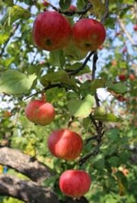
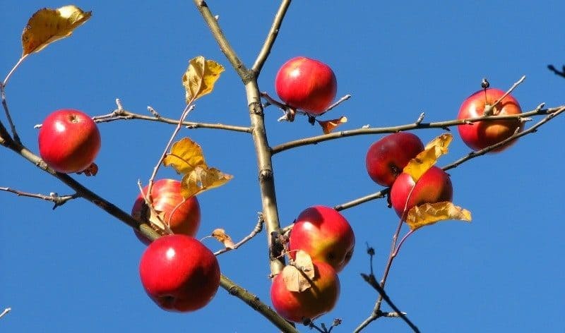
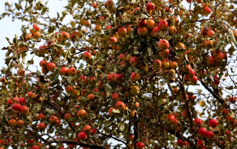
Soon we are in the small village of Taldy-Bulak, which is located at the beginning of the Turgen gorge, on the right bank of the river. We pass the village, the asphalt road ends, turns into a regular country road and gradually rises along the right side of the gorge to a small pass. In the southern part of the gorge there are vast meadows covered with single old Sieversii apple trees, which, judging by the size of the trunk, are more than 100 years old.
Along the right slope at first, for 300 meters, there is no forest, but soon the first Sievers apple trees appear. Before the pass, for 5 kilometers we drive through an apple forest, here sometimes there are hawthorn and apricot trees.
Apple forests in the gorge are represented by tracts of various sizes, small groups and individual trees along the entire length of the road. The Sievers apple tree is distributed almost everywhere at an altitude of 1150 to 1540 meters above sea level. Walking in the vicinity of the pass among the Sievers apple trees. Lunch in nature.
After lunch, transfer: valley Kuznetsov gorge – Turgen village – Issyk village – museum of archeology onIssyk mounds (33 km).
Visit to the Museum of History and Archeology, Issyk Saks burial mounds, walk in the surrounding area. Opposite the Issyk dachas is one of the most famous archaeological monuments of the Saks period of the IVth century - the Issyk mounds. In 1970, in the vicinity of the Issyk mounds, during archaeological excavations, a Saks warrior was found buried and belonging to the Saks-Tigrahaud rulers, possibly to the ruling dynasty of the Great Kushans.
The “Golden Warrior” was dressed in chain mail, richly decorated with gold plaques, a belt with weapons made of pure gold, and an arrow-shaped headdress on his head. The costume consists of four thousand gold jewelry - symbols, made in the famous “animal style”, characteristic of Saks artisans.
Transfer: Issyk mounds - Baiterek village - Guldala village - Almaty (49 km). Arrival in Almaty, transfer to the hotel, dinner, overnight.
Day 2. Almaty – Kazachka gorge (47 km).
Breakfast. Transfer: Almaty – Bolshoye-Almatinskoe gorge – Kazachka gorge (23 km).
Our path lies in the Big Almaty Gorge, we pass the Ile-Alatau Park checkpoint and immediately turn left along the road that leads to the Kazashka Gorge. The gorge stretches from west to east for 9 kilometers. The Kazashka River, 14.5 kilometers long, flows through the gorge, which originates from numerous springs on the western slope of the Kumbel-Tau ridge.
At an altitude of 1867 meters above sea level, the Kazashka River receives a tributary from the right, Terisbutak, 4 kilometers long, originating from the springs of the northern slope of the Kumbel-Tau ridge. Our excursion will start from the Kumbel hotel, which is located 5 kilometers above the mouth of the Kazashka River.
We will visit a picturesque birch grove on the northern slope, above which there will be individual and group trees of Sievers apple, cherry plum, small-leaved elm, and apricot. We will gradually walk down the road and visit the monitoring site of the Sivers apple tree in the valley of the Kazachka River, located in the lower third of a steep (about 45 degrees) gravelly, rocky slope of southwestern exposure (1500 meters above sea level).
The dimensions of the site are 50 x 50 meters. 3 species of trees grow here - apricot, Sivers apple tree, Djungarian hawthorn (Crataegus songorica C. Koch) and 4 types of shrubs - meadowsweet (Spiraea lasiocarpa Kar. et Kir.), rosehip (Rosa platyacantha Schrenk), Tatarian honeysuckle (Lonicera tatarica L.), gester (Rhamnus cathartica L.). Lunch in nature.
After lunch, transfer to the Ayusai visitor center (3 km). Visit to the visitor center, walk in the surrounding area. Transfer to the Sunkar bird nursery (3 km). The Birds of Prey show starts at 5 p.m. The performance involves several species of birds of prey, demonstrating under the guidance of a golden eagle falconer; you can see various methods of hunting.
Viewers will learn about the history of falconry, biological features and lifestyle of birds of prey. After the end of the show, transfer to the hotel (18 km), dinner and overnight.
Day 1. Almaty – Sarkand village (413 km).
Transfer: Almaty – Konaev town - Taldykorgan town - Zhansugurovo settlement - Sarkand settlement. Departure from Almaty at 7.00. The path from Almaty leads to the northeast, past the town of Konaev (formerly Kapshagai), which is the administrative center of the Zhetysu region.
The country's largest gambling zone with casinos and hotels is located in the roadside part of the town. The Kapshagai reservoir, 100 kilometers long, with beaches, boarding houses, hotels and holiday homes, is adjacent to the town.
Soon, along the bypass road we pass the town of Taldykorgan and then our path lies along the northern slopes of the Dzhungarskiy Alatau. Arrival in the settlement of Sarkand, late lunch at a local cafe. Transfer to the hotel, accommodation. Walk in the vicinity of Sarkand.
Transfer: Sarkand - Ekiasha village - Amanbokter village (43 km).
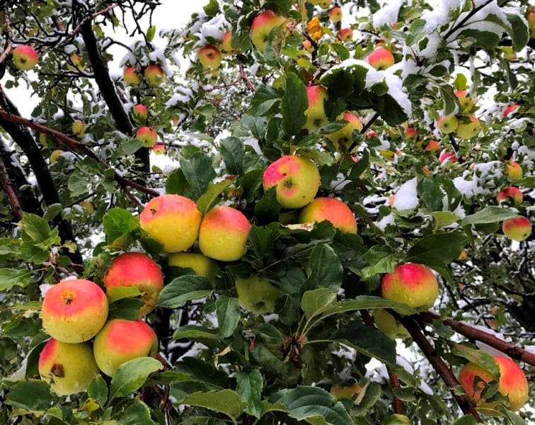
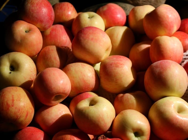
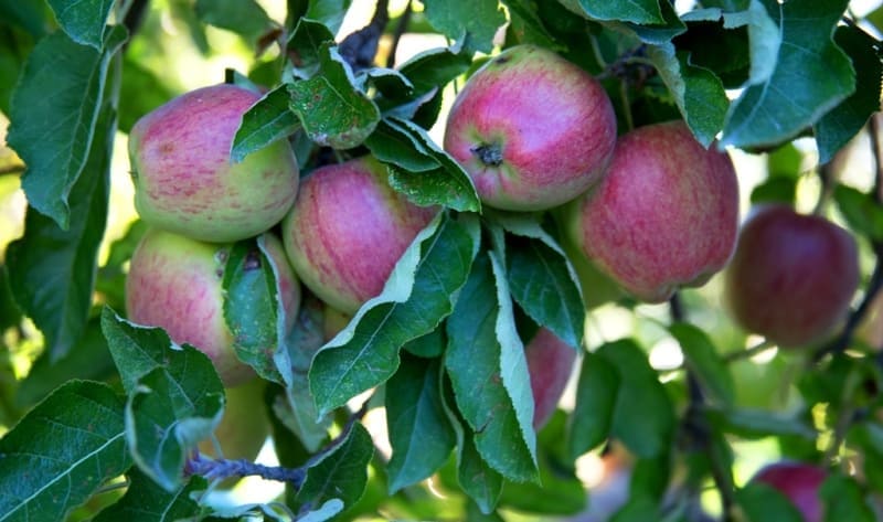
A walk in the vicinity of the Maly Baksan River. In the gorge of the Maly Baksan River there are single and small groups of Sivers apple trees. Apple fruits are characterized by a pleasant sour-sweet taste, beautiful appearance of the fruit,
They have a low tannin content and can be consumed fresh. The Sievers apple tree has high adaptability to winter conditions, drought, compatibility and productivity of grafted varieties.
Transfer: Malyi Baskan river – Bayanbay village – Avdia river gorge (Aulie-Tas valley) (17 km).
After the Malyi Baksan River, we drive along the western slope of the Akbulak massif to the south to a small peasant farm, after which our path lies along the right (eastern) bank of the small Avdiya River in the Aulie Tas valley.
Arrival at the stone valley Aulie-Tas, a walk in the surrounding area among the Sivers apple trees. Around you exude the aromas of herbs of this natural zone: oregano, sage, chamomile, etc. Here the air rings with the chirping of various insects and cicadas, echoing the voices of birds.
Transfer: Avdia gorge – Ekiasha village – Sarkand settlement (30 km). Arrival in Sarkand, dinner, overnight at a hotel.
Day 2. Sarkand settlement – Lepsi village (Lepsinsk) (94 km).
Breakfast. Transfer: Sarkand village – Ekiasha (Pokatilovka) village – Topolevka village (39 km).
From Sarkand our path lies to the southeast, along the northern slopes of the Markatau mountains. We pass the village of Ekiasha, which until 1993 was called Pokatilovka. The 11-time champion of Kazakhstan in freestyle wrestling Abilseit Aykhanov, actor Kuman Tastanbekov, who played one of the main roles in the film “Kyz-Zhibek” (1970), was born and raised in the village; the hero of the Soviet Union Vasily Belenko, a participant in Great Patriotic War.
We head to the village of Ekiasha, pass the bridge over the Bolshoy Baskan River and turn northeast to the next village - Topolevka, which is located in the northern part of the Zhamankotyrta Mountains. If desired, in the village you can visit the apiary of Pitenko beekeepers.
Transfer: Topolevka village – Terekty river – Kokzhota valley (7 km).
The Kokzhota valley is located on the northern slope of the Dzungarskiy Alatau Mountain in the upper reaches of the Vasilyev Klyuch River, in the northern part of the Gorely Log valley and in the northwest of the Mynbulak valley.
In the Kokzhota valley we will meet individual Sivers apple trees and small groups. Constant companions of the Sievers apple tree are two types of trees: Songara hawthorn (Crataegus songarica) and common apricot (Armeniaca vulgaris). Walk along the left bank of the Terekty River.
Further transfer: Kokzhota valley - Terekty river - Mynbulak valley - Maket Kol lake (14 km).
We pass the Terekty River, here is a picturesque place - granite slabs slope down into the river. Water flows among the thickets of aspen forest, apple trees, and bushes. From the Kokzhota valley our path lies northwest to the southern slopes of the Shatyrbai ridge.
From here we turn northwest and drive along the picturesque Mynbulak valley. The Mynbulak valley is located in a small intermountain depression in the northern part in a natural depression where Lake Maket kol is located, this is one of the picturesque places in the northern foothills of the Dzhungarskiy Alatau.
ake Maket kol is located at an altitude of 1093 meters above sea level; in its northern part there is a bulk dam that blocked the sources of the Maly Zhalanash River. In the southwestern part of the lake grows the rare Lychnis, a flowering plant with red flowers, which gives the lake a unique color against the backdrop of the snowy peaks of the Dzungarskiy Alatau. Walk around the lake.
Transfer: Lake Maket kol – Aganakty River – Bolshoi Zhalanash River – Karbushka River Gorge (11 km).
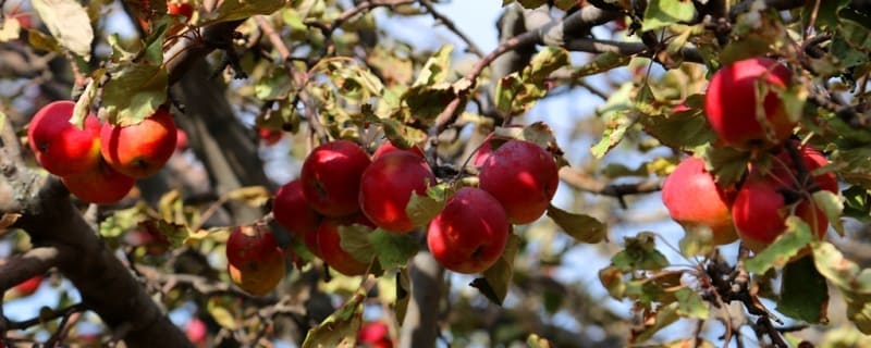
From Maket Kol our path lies to the east, we cross the Aganakty River bridge and head to the Karbushka River gorge. On the left bank of the river there are thickets of Sievers apple trees; just above on the right bank of the river there is a forest nursery.
Sievers apple tree (Malus sieversii) from the Rosaceae family, listed in the Red Book of the Kazakh SSR in 1981. In the Dzungarian Alatau, the Sievers apple tree occupies 48.8%. On the territory of Kazakhstan there are about 75% of Sivers apple groves, which are concentrated mainly in the Trans-Ili and Dzungarskiy Alatau.
On the territory of the Zhongar-Alatau Park it is found in the Kokzhar Topolevka, Zhalanash, Chernovsk areas at an altitude of 1100 - 1850 meters above sea level. Walk in the surrounding area.
Transfer: Karbushka river – Zhalanash valley – Aganakty river – Lepsi village (Lepsinsk) (15 km).
We ford the Karbushka River and move along the right side of the river valleys of Aganakty and Bolshoy Zhalanash to the village of Lepsi. The village received its name from the Lepsy River, whose sources are located on the northern slope of the Dzungarskiy Alatau.
During the reign of the Dzungars, there was a headquarters of one of the Kalmyk khans here. With the defeat of the Khanate in 1758 by the Manchus and Chinese, the empty lands of Semirechye began to be populated by the Kyrgyz and Kaisaks of the Middle and Great Hordes.
The first settlers settled here in 1855 - 1856; they were two hundred Siberian Cossacks from the VIth, VIIth, VIIIth and IX9th regiments of the Siberian Linear Cossack Army and 200 peasant families. The first batch of Cossack migrants arrived on June 18, 1855.
The valley of the Lepsy River was chosen as the place for settlement. Arrival in the village of Lepsi, accommodation in a guest house, lunch.
Transfer: Lepsi – Lepsi forest nursery (2.3 km).
After lunch, visit the forest nursery of the Lepsinsky branch of the Zhongar-Alatau Park. The forest nursery is located in the southern part of the village at an altitude of 1019 meters above sea level. More than 18 species of tree species are grown in the nursery.
Here you can get acquainted with the technology of growing Sievers apple trees and the main measures for sowing and caring for young plants. Here they are trying to preserve the Sivers apple tree, which has existed since the time of the dinosaurs and has survived all natural disasters, and to increase its number.
At the Sarkand, Lepsi and Alakol branches of the Zhongar-Alatau Park there are several nurseries where Sivers apple trees are grown. End of the excursion.
Transfer: Lepsinsky forest nursery – Chernaya Rechka cordon (12 km).
From the village we drive first along the left bank of the Piketny stream and gradually the country road turns to the southeast. Along the way we pass two small lakes overgrown with reeds; in the fall these lakes almost dry up.
oon the road leads us to the Chernaya Rechka cordon, which is located at an altitude of 1221 meters above sea level on the left bank of the Chernaya Rechka River. The cordon and its buildings are located among apple trees, one of them, an old Sievers apple tree, grows in the cordon fence.
On the eastern side, the cordon is surrounded by an acacia hedge. Formalities for passing through access control.
Further transfer: Cordon Chernaya Rechka – Chernovsk valley (Rodmir Vishnyakov’s apiary) (4 km).
The road from the cordon leads us to a ford across the Chernaya Rechka River. The road is narrow and rarely visited by cars, replete with steep ascents and descents, the sides of the road are overgrown with raspberries and other bushes that completely blocked the road. Soon we are at the apiary, which is located in a picturesque, open place.
Hiking: apiary - long-lived Sievers apple tree (1.5 + 1.5 = 3 km).
From the apiary begins the ascent to the southeast along the old path, which passes among tall grass, bushes: Semenov's euonymus (Euonymus semenovii), Tatarian honeysuckle (Lonicera tatarica), spherical barberry, Bykova, heteropod (Berberis sphaerocarpa), laxative jockstrap, kushina laxative (Rhamnus cathartica), gray blackberry, common blackberry (Rubus caesius, R. idaeus).
The companions of the Sievers apple tree are two types of trees: Songara hawthorn (Crataegus songarica) and common apricot (Armeniaca vulgaris). Soon we reach the place where the long-lived Sievers apple tree grows.
The apple tree is located at an altitude of 1458 meters above sea level. From here you can observe a beautiful panorama of the Lepsy River, thickets of apple trees, picturesque views of the mountains According to DNA studies, it has been proven that the Sieversii apple tree is the ancestor of most cultivated varieties of apple trees.
This long-lived Sievers apple tree grows alone in the region on the northern slope of the Dzungarian Alatau ridge, between the Vankova Griva ridge in the west and the Zhunzhuru mountains in the east. The apple tree reaches a height of 18 meters, the trunk diameter at the base is 1.8 meters, and the crown diameter is 15 meters.
Using a special technique developed by specialists from the Lepsinsky branch of the Zhongar-Alatau Park, the age of the Siver apple tree was determined (as an exception); it was 300 years. Walk in the surrounding area, visiting the ancient Sievers apple tree.
End of the excursion, return to Lepsi (17.5 km).
Arrival in Lepsi, accommodation in a guest house, dinner, overnight.
Day 3. Lepsi – Almaty (547 km).
Breakfast. Transfer: Lepsi – Kabanbai village – Koilyk settlement – Sarkand settlement – Zhansugurov settlement – Taldykorgan town (284 km). Lunch at a local cafe.
Further transfer: Taldykorgan - town Konaev - Almaty (263 km). Arrival in Almaty, transfer to hotel, accommodation, dinner and overnights.
Day 6. Almaty.
Transfer to airport, departure from Almaty.
Details of program “Tour for Sivers apple trees in autumn” in Zhongar-Alatau Park:
1. In the village of Lepsi, accommodation is in a private, rural house, which does not have a bathroom - toilet and shower. The village toilet is located in the courtyard of the house. If desired, you can prepare a Russian bath with hot and cold water.
2. There are no cafes or restaurants in the village. Meals (lunch and dinner on the first day, and breakfast on the second day) will be in a private home, prepared by the family. During your stay, you can get to know better the family customs and everyday traditions of a modern Kazakh family; it can also be a family of a different nationality.
3. Part of the route passes along the Sarkand – Topolevka highway. Along the way you can see stone and granite slabs on the Terekty River - a place for rest and bathing of the local population, rock paintings of Bayanbay, the Aulie Tas valley with picturesque and relief granite remains.
Additional trips and walks from Lepsi:
Walk to Lake Zhasylkol.
Distance of route: 50 km.
Tour duration: 1 day.
Distance of active part of tour: 8 - 10 km.
Lepsi village - Zhasylkol lake (8 km).
Transfer: Lepsi village – Zhalanash cordon – Martynov apiary – Zhasylkol cordon (25 km).
Arrival at the Zhasylkol cordon, start of the walk to Lake Zhasylkol.
Hiking: Zhasylkol cordon – Zhasylkol lake (4 km).
First, from the cordon we climb along the Aganakty River, then, gradually, the trail moves away from the river and begins the ascent to an ancient moraine, which blocked the river bed and formed a lake. The flowing, fresh lake Zhasylkol is located at an altitude of 1630.5 meters above sea level, located on the northern slope of the Dzungarskiy Alatau ridge in the valley of the Aganakty River.
The greatest length of Lake Zhasylkol from the northern to the southern shore is 1.9 kilometers, the greatest width of the lake in the southern part of the lake is 525 meters. In the northern part, the greatest width of the lake reaches 632 meters.
The area of the lake is 0.95 square kilometers, the length of the coastline reaches 5.2 kilometers. The delta of the Aganakta River in the southern part of the lake is 312 meters. Flowing through the lake, in the southwestern part the river overcomes huge rocks in the riverbed and forms a cascade of waterfalls outside the lake. Walk around the lake. Lunch on the shore of the lake.
Return to Zhasylkol cordon (4 km). Transfer: Zhasylkol cordon – Zhalanash cordon – Lepsi village (25 km). Arrival in Lepsi, end of the walk.
Trip to Uygen-Tas mound.
Distance of route: 74 km.
Tour duration: 1 day.
Lepsi village – Uygentas mound (37 km).
Transfer: Lepsi village – Koktobe pass (9 km).
We leave the village of Lepsy to the north, cross the bridge over the Lepsy River and immediately turn east, passing the rural hippodrome, which remains on our left side. We drive 7 kilometers from the bridge over the Lepsy River and gradually begin to climb the mountains.
Our path lies to the Koktobe pass, 1797.5 meters above sea level, which divides the Zhanzhurek mountains into western and eastern parts. The Zhanzhurek Mountains are the northern spur of the Dzungarian Alatau ridge, which stretch 13 kilometers in the latitudinal direction.
The eastern border of the mountains is the Tentek River, in the south the mountains border the right bank of the Lepsy River, in the west the mountains gently descend into the valley of the Lepsy River. The highest point of the mountains is the peak of Koktobe, 1814.4 meters above sea level, which rises 500 meters in the southeast of the Koktobe pass.
At the pass there is a radio broadcaster that provides communications and television to the villages of Lepsinsk and Zhanzhurek. Stop at the pass. From the pass a picturesque panorama of the northern slope of the Dzungarskiy Alatau ridge and the surrounding area opens up. A short walk in the environs of the pass.
Transfer: Koktobe pass – Tentek river – Uygentas mound (28 km).
Our path lies to the east, we move among the hills, cross the sources of the Krutaya River, which is the left tributary of the Lepsy, and gradually begin our descent into the valley of the Tentek River. Before descending to the Tentek River, Mount Zhunzhuru rises in the south, 1733 meters above sea level.
The road takes us to the left bank of the Tentek, from here we turn at an acute angle and head south, passing a ford across the small river Rybny Klyuch, which flows into the Tentek on the left. After 1.5 kilometers we cross the bridge over the Tentek River to the right side and after 600 meters we reach the Uygentas mound.
The mound of oval stones Uygen-Tas is located at an altitude of 1374 meters above sea level, located between the Tentek and Ipili rivers. Here, 250 meters south of the Uygen-Tas mound, there are L-shaped ruins with slumped earthen walls, which consisted of five rooms with separate entrances measuring 20 x 10 meters.
140 meters northwest of the mound there is another completely identical L-shaped structure. Dimensions of the Uygen-Tas mound: height 6 meters, length of the mound from south to north 65 meters, width from west to east is 74 meters, area of the mound is 3778.78 square meters, perimeter of the mound reaches 221 meters.
Apparently, the mound is a funerary burial. On the right bank terrace of the Tentek River, in the vicinity of the mound, there are about ten small burials. In the southern part of the mound there is a reinforced concrete structure without inscriptions.
Judging by the sunken, collapsed central part, the mound was plundered in ancient times. No modern excavations or surveys have been carried out by archaeologists. The well-known legend about Tamerlane, who passed here with his army, is associated with the mound.
The terrible ruler ordered each of his warriors to put a stone in a pile. Returning, each warrior also took one boulder from the pile. The remaining and counted stones gave the number of those killed in the battles. A very similar San-Tash mound, somewhat smaller in size, made of the same oval stones, is located in the Tyup district of the Issyk-Kul region in the southeastern part of the Kungei Alatau ridge.
The Kazakh explorer and traveler Chokan Valikhanov visited the San-Tash mound in May 1856. Walk in the vicinity of the mound. Lunch on the banks of the Tentek River.
Return to village of Lepsi (37 km). Arrival in the village of Lepsi, end of the trip.
Note:
Author program is Alexander Petrov. Copying and use of a material - from the sanction of the author.
Authority of introductory article:
Sivers apple tree in Ile-Alatau National Park: results and prospects of monitoring Ainabekov M.S., Turekhanova R.M. Ile-Alatau State National Natural Park.”https://www.acbk.kz/elfinder/files/Data%20zone/Library/theriology/ile_alatauskogo_gnpp_2015_1.pdf
Photos by
Alexander Petrov.