


You are here
Kyrgyz ridge.
Tours in Kyrgyzstan mountains.
“All that is gold does not glitter,
Not all those who wander are lost”
J.R.R. Tolkien.
Trekking in Kyrgyzstan mountains.
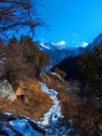
Kyrgyz ridge (Kyrgyz Ala-Too or Alatau), the ridge is located in the mountains of the Northern Tien Shan, in the north of Kyrgyzstan, partly along the border with Kazakhstan. The ridge is 375 kilometers long. Peak Semenov-Tyan-Shanskiy with a height of 4895.4 meters above sea level is the highest Kyrgyz ridge.
In the middle part it is connected with the Talas ridge, and through the watershed jumper of the Karakol Zapadny and Karakol Vostochny river basins - with a short (about 70 kilometers) ridge Karamoynok located to the south and almost parallel to the Kirghiz and entering the Jumgalatau system.
The Tuz-Ashuu Pass, 3,586 meters above sea level, divides the Kyrgyz Range into western and eastern parts. West of the Tyuz-Ashuu pass, the Talas Alatau adjoins the Kyrgyz ridge from the south. To the east of the Zapadny Alamedin massif, a long (up to 30 kilometers) jumper connects the Kyrgyz ridge with the Kara-Moinok ridge (about 50 kilometers long and up to 4281 meters above sea level), carrying more than 70 glaciers with an area of about 30 square kilometers, and the Jumgal-Too ridge ( with a length of more than 100 kilometers, a height of 3948 metro above sea level), which also has more than 70 glaciers with an area of about 30 square kilometers.
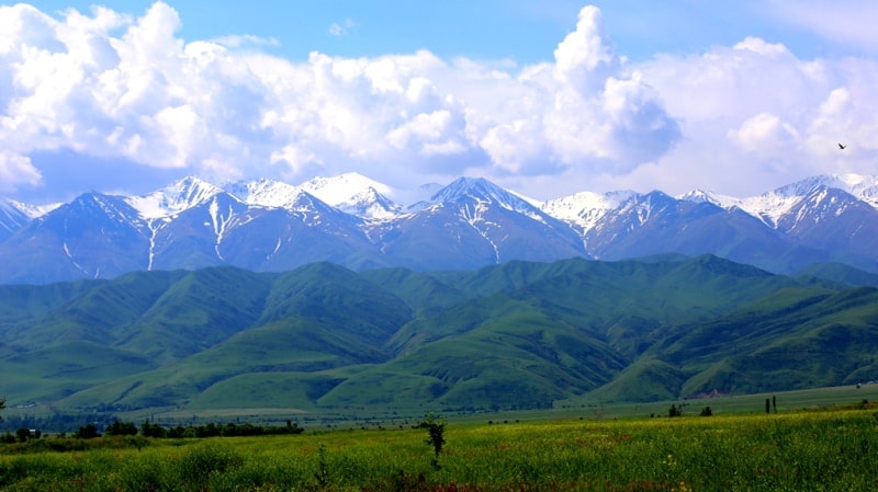
The western part of the Kyrgyz ridge (up to 3817 meters above sea level) is slightly dissected, with slight glaciation. The steep northern slope facing the Muyunkum desert, with elevations from 1000 to 3500 meters above sea level, a gentle southern slope descending to the Talas valley, with elevations from 2000 to 3500 meters above sea level.
Near the Tuz-Ashuu pass, the Kyrgyz ridge on the northern slope has more than 100 glaciers. The eastern part of the Kyrgyz ridge is characterized by alpine relief and extensive glaciation - about 600 glaciers, with an area of up to 500 square kilometers.
The slopes of the Kyrgyz ridge, facing the Chuy valley, are strongly divided into spurs up to 50 kilometers long with elevations from 1,500 to 4,000 meters above sea level. The southern slope of the eastern part of the Kyrgyz Range has short (up to 25 kilometers) valleys with elevations from 3000 to 4000 meters above sea level.
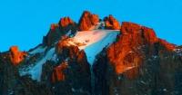
The peaks of the Kyrgyz ridge reach almost 5000 meters above sea level, the highest - peak Semenova-Tien Shan, a height of 4875 meters above sea level and a peak of West Alamedin, a height of 4856 meters above sea level.
Most significant spurs of the Kyrgyz ridge.
Eastern spur of the Kyrgyz ridge, with a length of 200 kilometers, is located at an altitude of 3530 to 4300 meters above sea level.
Northern spurs of the Kyrgyz ridge, with a length of up to 50 kilometers, are located at an altitude of 2900 to 4450 meters above sea level.
Southern spurs of the Kyrgyz ridge, with a length of up to 30 kilometers, are located at an altitude of 3600 to 4000 meters above sea level.
Spur Kara-Moinok, with a length of about 50 kilometers, is located at an altitude of 3600 to 4281 meters above sea level.
Spur Dzhumgal-Too, with a length of over 100 kilometers, is located at an altitude of 3500 to 3948 meters above sea level.
Geographic coordinates of the Kyrgyz ridge: N42 ° 28'29.88 "E73 ° 49'35.76"


Authority:
"Kyrgyzstan". Publishing House "Thought". Moscow city. 1970.
Photos by
Alexander Petrov.