


Вы здесь
Glaciers of Oktyabrsky.
Expedition on mountain all-terrain vehicles in Tajikistan.
“... My eyes ... persistently looked south, enchanted by the grandeur of the panorama and the complete unknown that is there. But a massive snow ridge, like a wall, stretched in front of me at a distance of some 30 miles. At that time, I had not yet foreseen that these mountains would really become a wall for me, beyond which I would not see anything. I was in a hurry down to penetrate these mountains, and dreamed that I would reach the places where the natives' imagination places a "roof of the world" (Bam-i-dunea). Alas, I did not suspect that I was destined to confine myself to the orders of the Kyrgyz colonel to contemplate only the edge of the "roof of the world." Without sadness, I still can’t remember the disappointments that I had to experience in Alai. But what to do? It remains to be expected that if I do not see it myself, I will learn from others what lies behind these mountains”
A.P. Fedchenko. "Journey to Turkestan." M., 1950, p. 356.
Jeep safari in Zaalai ridge of Tajikistan.
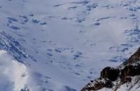
Upper limit of Oktyabrsky glacier is located at altitudes: 6683 (peak Kyzylagyn), 6218 (peak Latvia), 6202 (peak Estonia), 6690 (peak Unity), end of glacier is located at an altitude of 4282 meters above sea level, located on southern slope of Trans-Alai ridge in Murghab district in north of Gorno-Badakhshan Autonomous Region.
The length of the Oktyabrsky glacier is 19.0 kilometers, its area is 88.2 square kilometers. The glacier is located at the junction of the Trans-Alai ridge with the Zulumart ridge in the upper reaches of the Koksay River and belongs to the Karakul Lake basin.
The Koksay River flows from the glacier, which is a left tributary of the Karadzhilga River. Its main stream descends from the steep southern slope of the Trans-Alai ridge to the very ridge, completely covered with firn and snow. The feeding area consists of 6 wide chambers.
The tongue is broken along its entire length by cracks, and the lateral tributaries are also severely fragmented. Median moraines are well defined - their dark stripes can be traced to the end of the glacier. The ice surface, free of moraine, is covered with ablative landforms.
The right tributaries flowing from the eastern slope of the Zulumart ridge have narrow moraine tongues pressed by the main trunk to the right side of the valley. To the west of the Oktyabrsky glacier, on the other side of the Zulumart ridge, from the southern slope of the Trans-Alai ridge, in the area of Lenin Peak, 4 large glaciers descend - Big Saukdara, Small Saukdara, Dzerzhinsky and Vali.
These glaciers have extensive firn areas lying at high altitudes and long narrow tongues. A special feature of these glaciers is the periodic movements of their tongues, during which they descend into the floodplain of the Sauksay River and block it.
Geographical coordinates of Oktyabrsky Glacier: N39°20'48 E72°58'52


Authority:
"Glaciers." L.D. Dolgushin, G.B. Osipova. Series "Nature of the world." Moscow, the publishing house "Thought". 1989.
Photos by:
Alexander Petrov.