Вы здесь
Ancient settlement Toksanbay.


Small group holidays in Kazakhstan.
"Pale mists are thinning
Over the abyss of fatal death,
And again they stand before me
The centuries passed by are giants;
They call, they beckon
They sing and I sing after them
And full of feelings alive
I'm afraid to look back"
Mikhail Lermontov.
Trip on ancient settlement Kazakhstan.
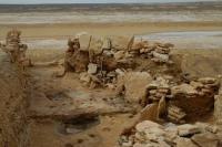
The proto-urban settlement of Toksanbay is located in the northeastern part of the Shomshikol salt flat, on the eastern side of the Northern Chink of the Ustyurt plateau in the western part of the Toksanbay tract on the eastern bank of the salt marsh there is a settlement in the Toksanbay valley, 56.8 kilometers northeast of the Turysh village, at 112, 5 kilometers northeast of the village of Beineu, Beineu district, Mangystau region.
The proto-urban settlement of Toksanbay has an excavation area of 200 meters and dates back to the III - II millennium BC. The archaeological site of the Early Bronze Age appeared, according to radiocarbon analyzes, 4000 years ago.
The Toksanbay ancient settlement was discovered in the early 90s of the last century, it is a multi-layer fortified structure. In 2009, research was carried out over the entire area of the settlement, the main attention was paid to the study of objects that are an integral part of structures on the northwestern slope, the middle part of the outlier and on the southeastern slope.
On the southeastern slope, a study has been completed of a pit filled with animal bones and items made of stone, bone, and fragments of ceramics. The study of the cluster began at a depth of 110 - 115 cm. Fragments of tubular bones (kulan?), Articular, teeth, scapula, rib, jaw, hoof, astragalus (saiga?), Vertebrae, a predator's jaw were recorded at the bottom of the pit in the northwestern sector. in addition, a large fragment of a sidewall with rims from a pot-like vessel and a fragment of a mortar.
The southwestern and southeastern sectors are saturated with bones lying in various directions and in an arbitrary arrangement - scapula (saiga?), Split tubular bones, half a hoof (artiodactyl), phalanx, knee joint, ribs; further to the middle of the pit, split tubular bones, as well as a small fragment of the upper part of the vessel with a rim, a flint flake, two fragments of the bottom parts, a stone hammer.
After removing the top layer of bones, the last layer along the bottom, also saturated with small fragments and splinters of bones, was cleaned. The bottom had a relatively flat, whitish surface, probably from deposited carbonate layers.
The pit walls are hemispherical, of which the northwestern side is washed out in the upper part, and the northern side of the pit is damaged. The final stage of research, in a room on the southeastern slope, in the altar room, was to clear a box in the corridor.
The box is built of flat stones dug in vertically, and is located below the level of the corridor by 27 - 30 cm.The slabs rise above the floor level by 7 - 10 cm. The bottom of the box is a flat stone slab. A box measuring 50 - 60 cm.
The north-western half of the room was investigated, in the middle part of the outlier. The floor in the room is underlain by a continental layer consisting of gravel in light brown loam above this layer, where it is not disturbed by digging, there was a layer of carbonate clay.
In the middle part of the room, an accumulation of items and tools was cleared, apparently constituting a sacrifice. The middle part of the room was occupied by a burnt filling, in which, in addition to ash, there were remains of burnt wood and animal bones.
The main concentration of the burnt filling was concentrated in the depression. Along the perimeter of the depression, along the northwestern wall, there were pits, apparently pillars. The depression, apparently, was associated with the first floor level; later it was filled with a layer of clay, under which lay a coal-ash layer up to 5 cm thick.
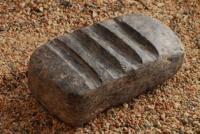
Another fragment of the floor was cleared behind a depression on the southeast side. Here the dense coating was smoked. In the northeastern part of the room, a cluster has been cleared, consisting of polished stone tools - a ball, a pestle; a bone spoon, a fragment of ceramics from the side of a vessel with a wavy ridge, ornamented with a zigzag of incised lines framed by incisions.
On the northeastern side, in the destroyed part of the floor, two pits were cleared, one of which contained stone products: on top, almost at the level of the pit, a pestle lay in a horizontal position, below a mortar, in turn, the mortar rested on a narrow pestle, which stood vertically under it. position.
All three items were polished; a miniature mortar was placed at the very bottom of the hole. Near the cluster, there was a hearth, which was an oval-elongated pit, with walls smoothly tapering to the bottom. In the filling of the hearth, there are many charred and calcified animal bones, mainly small fragments, as well as a few small fragments of ceramics, small charred stones and coals.
On the northwestern, northern, and northeastern sides of the hearth, there were pits, presumably pillars, that make up a certain system in the location. Large pits, located almost along the west-east line, followed the direction of the stone wall and were arranged along it from the inside of the room.
From the stone part of the wall, a fragment of three vertical slabs of the outer circumference of the wall has been preserved, the base of the wall has been preserved almost in its original form. This gives an idea of the construction of the lower part of the entire wall: vertically installed slabs, sometimes in two slabs, installed tightly to each other, with a gap between them, which was filled with earth and stone masonry.
The internal gap between the vertical slabs was 35 - 40 cm, the gap between the outer row of slabs was from 50 cm to 60 cm.
Еhus, the second remaining wall for the characterized lower room was a common wall with the rooms to the north slope. This wall, like all structures, had repeated completions in accordance with the general redevelopment of the premises at different periods of the outlier's residence.
The next important object of research was a dwelling on the northwestern slope of the outlier. The clearing of premises on the northwestern slope of the outlier in the 2008 field season was brought to the level of the lower structures that existed before the fire in this part of the settlement.
The room is divided into two parts by a stone wall or partition. This partition wall runs behind the hearth from the northeast side. The space between the hearth and the wall on the northeastern side has been cleared to a depth of more than 350 cm.
Along the edge of the structure above the cliff, masonry was cleared in a burnt layer, consisting of three lowermost, two middle and two upper slabs of an elongated rectangular shape. Above and along the masonry lay a strip of burnt layer reaching 110 cm in width, the rest of the space between the burnt layer, limited by the masonry and the main two-tier wall on the southeast side was occupied by a strip of stones of medium and large sizes.
The flat stones were laid flat, mostly in two stones. This stone pavement had a width of 170-200 cm. Above it there was a layer of 30-40 cm of smaller crushed stones, mixed with bone-earth filling (garbage, household waste), saturated with bone remains.
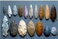
Fieldwork confirmed the uniqueness of this site and the prospects of research into the problems of the formation of proto-city cultural complexes on the Ustyurt plateau in the age of the paleometal. As a result of research, the collection of artifacts from the settlement was replenished with items made of bone, stone, silicon, clay, archaeologically intact vessels and their fragments.
Geographic coordinates of the proto-urban settlement of Toksanbay: N45 ° 51'00.82 "E56 ° 33'34.61"
Authority and photos:
Samashev Z., Ermolaeva A.S., Tatiana Loshakova, Scientific Secretary of the Branch of the Institute of Archeology named after A. Margulan in Astana. http://toksanbay.kz/


