


![]()
Вы здесь
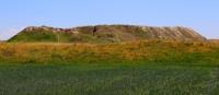
Ancient settlement Kuik Mardan.
Travels across Kazakhstan.
“Our entire history is a product of the nature of that vast land that we have inherited. It was she who scattered us in all directions and scattered us in space from the first days of our existence"
Chaadaev P. Ya.
Ancient settlements in Kazakhstan.
Ancient settlement Kuik Mardan is located 60 meters east of the Shaulder - Turkestan highway, 7.3 kilometers from right (eastern) bank of Syr Darya River, 7.4 kilometers northwest of Otrar settlement, 16.3 kilometers from east and slightly north of village of Mayakum, 9 kilometers north and slightly west of village of Kogam in Otrar district of Turkestan region.
The ancient settlement Mardan-Kuik (Kaz. Mardankuyik) is a part of the Otrar oasis. A monument of history and culture of local significance of the Turkestan region. A nearby necropolis, now known as Konyrtobe, was associated with the ancient town.
Modern historiography claims that the settlement arose in the Ist century AD. e. As in the case of many other cities of the Otrar oasis, its founders were residents of the Kangyui state. The most ancient parts of the city are the citadel and the shahristan.
In the VIIIth century, the city experienced a fire. Kazakhstani historians E. Smagulov and M. Kozha argue that the fire is associated with the conquest of the city by the Arabs. Shahristan fell into decay after the fire. However, in the IXth - XIIth centuries, a rabad was formed away from the citadel.
Mardan Kuik remained a fairly large city until the XVth century. However, in the XIII - XIV centuries, only the eastern part of the rabad remained inhabited. Later the city was almost abandoned, but the population finally left the city only in the XVIIIth century.
The settlement consists of three hillocks and an adjoining site surrounded by a wall. One of the hillocks is the remains of a citadel, the other is a shakhristan, and the third is a tower guarding the main entrance to the town. The former citadel corresponds to a sub-rectangular flat hill 55x50 meters in size and 14 meters in height.
From the entrances to the citadel on the southwestern and northeastern slopes, there are hollows. In some places, the remains of the fortress wall and individual buildings of the latest time have been preserved. Shahristan adjoined the citadel from the southwest side.
An oval hill with dimensions of 180x150 meters and a height of 7-11 meters remained from the shakhristan. Remains of buildings of the upper building horizons are traced on the hilly surface. The tower at the main entrance was located 15 meters west of the citadel.
The tower corresponds to a mound of irregular shape, measuring 40x10-15 meters and a height of 14 meters. The area between the hillocks is oval in shape, measuring 60x30 meters. Adjacent to the shakhristan was a sub-rectangular rabad with dimensions of 650x250 meters, surrounded by a wall.
The southern part of the rabad is flat, the northern part is elevated, hilly, 6-7 meters high. In the eastern part, there is a round-shaped hillock, 8 meters high. In terms of layout, Mardan-Kuik is similar to the nearby settlement of Kokmardan. Urban development was subdivided into quarters.
Residential buildings consisted of one or two rooms. In two-room houses, the second room was a storage room, separated from the main room by a solid wall. Raw bricks were used for construction. The first characterization of Mardan Kuik was made by the Soviet archaeologists E. I. Ageeva and G. I. Patsevich.
Later, in the Soviet years, the settlement was examined by the South Kazakhstan complex archaeological expedition under the leadership of K. Akishev. Archaeological excavations at the site began in 1986 and continued in 1987. During the excavations, a description of the residential buildings of two periods was compiled: IV-VI and VI-VIII centuries.
In 2004, restoration work was carried out on Mardan Kuik. During the excavations, both iron products and pieces of iron lattice were found, testifying to the smelting of iron in the city. Other finds include coins of the VIIth - VIIIth centuries, various bronze items, and Kangar pottery.
Pottery from the period after the IXth century is often found lying in excavations near the surface. Among the finds of agricultural origin are grain, peach and apple pits, unpeeled cotton seeds. The most typical lifting material is ceramics of the IIIrd - Vth centuries.
The object is included in the list of archaeological monuments of history and culture of local importance in the Turkestan region of Kazakhstan.
Geographic coordinates of Kuik Mardan settlement: N42°54'12 E68°14'50
Authority:
https://ru.wikipedia.org/wiki/%D0%9C%D0%B0%D1%80%D0%B4%D0%B0%D0%BD-%D0%9A%D1%83%D0%B8%D0%BA#:
Alexander Petrov.
Photos by:
Alexander Petrov.