


![]()
Вы здесь
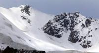
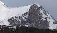
Sights of Muzkol ridge.
Mountain hiking in Tajikistan.
"The mountains! Their snow-white, dazzling domes against the background of inconceivably blue and deep blue - aren't they a symbol of a human dream, the call of which has troubled audacious souls for centuries? And isn't each of us given his own height in the chosen business?"
Mikhail Turkevich.
Mountain peaks Tajikistan.
"Muzkol" means "icy river" in translation. This river is really icy: it thaws only in summer during daytime hours, murmurs among ice and stones. The ridge has the same name. He is also wearing ice armor. Muzkol is high, deserted and dry everywhere.
Already in the valley at the level of the river, the height reaches 4000 meters above sea level. You rarely meet a person here. People live in spurs, where there is water and cattle can be grazed. Periodically, Muzkol is visited by expeditions: geologists are looking for minerals, biologists - high-altitude and frost-resistant plants, zoologists are also looking for something, possibly traces of the stay of the mythical "Bigfoot".
The first organized tourists from Moscow came to Muzkol in the summer of 1974. They penetrated into the center of the massif, explored a number of central glaciers and gorges, and visited the foot of the highest peak of Soviet Officers, 6233 meters above sea level.
The tourists managed to get on an all-terrain vehicle to the area of the Aktash pass with an altitude of more than 4000 meters above sea level. Further, a relatively flat desert valley, a small green oasis and again a desert.
Brownish, red loess crumbling underfoot is mixed with stones of all sizes and colors. At noon, the temperature here approaches + 30 °, dry. Even a strong headwind does not calm the heat. It is constant: it blows from west to east, gains strength by noon and gradually dies down by night.
There are many desert places in the Eastern Pamirs. They are called dead, as, for example, Markansu - "dead water". Water in local rivers lasts from April to July. And even in these months, some streams and rivers dry up in the morning.
Few streams at noon and on glaciers. Usually, Muzkol receives no more than 200 mm of precipitation per year, mainly in the form of snow. Some of the moisture does not reach the ground, evaporating in the air. True, here, too, sometimes several annual norms fall out over the summer.
In summer, not only small rivers dry up, but by August the “big” river - East Pshart - also dries up. Glacial rivers, and especially those that run towards Lake Sarez, have enough water in the summer. These are the Western Pshart, Sauksay, Sasyk, etc.
In the upper reaches, the Western Pshart flows calmly, but, approaching Murghab and entering a gorge with steep steep banks, it becomes wayward and insidious.Before the first canyon, we needed to set up a canyon crossing, and then numerous ford crossings followed.
Fifteen crossings were made through the main channel and about twenty-five through the lateral and secondary arms. And all this on a small stretch of the road. Sometimes they write that the mountain ranges of the Eastern Pamirs, despite their high altitude, are distinguished by a relatively small ruggedness and smooth outlines characteristic of a mid-mountainous relief.
This is true only for certain areas of the highlands, but it is not very suitable for Muzkol. In terms of dissection and height difference (up to 2 kilometers), it can be compared with the classic mountainous regions of the country.
A dozen peaks have risen above 6000 meters here, several dozen exceed Elbrus. And if the river valleys lie at an altitude of 3.5 - 4 kilometers, how can we talk about the small indentedness of the slopes ?! Sheer walls rise several hundred meters on the Muzkol.
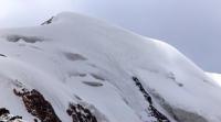
The latitudinal Muzkol ridge is characterized by steep, often sheer rocky walls on the southern side and more gentle northern slopes covered with snow and ice. Gigantic talus slopes are interspersed here with smooth plumb lines.
Especially beautiful in a snow-ice frame are brownish, orange monoliths, dissected by light lines of golden pyrite.In comparison with the Caucasus, everything here is raised by almost 2 kilometers. You have to work at altitudes of more than 5000 meters, where the air is thin, the movements are difficult, they are measured, like in slow motion.
The “middle” Muzkol pass lies at an altitude of 5300 meters above sea level. Many saddles in the central part of the region rise above 5500 meters above sea level. So, the Uzlovaya pass (upper) has a height of 5860 meters above sea level, and Soviet Officers (eastern) - 5680 meters above sea level.
At home, all the passes seemed to us calm and not very difficult (there was no quality information). In fact, it turned out differently: even without taking into account the difficult long approaches, many passes "jumped" by one, or even one and a half categories of difficulty in comparison with the assumed one.
That is why we had to refuse to pass a number of passes (Muzkol, Uzlovy, Double-headed and some others). There are over 100 glaciers on the Muzkol. About 70 of them descend from the northern slopes. They are small: rare precipitation and dry air do not contribute to the formation of large glaciers.
The largest, and there are only 5. of them, do not exceed 7 kilometers in length. They are concentrated in the center of the massif, between the northern spurs of Bozbaital and Zortashkol, and only one, the Soviet Officers' glacier, with an area of about 20 square kilometers, is located west of Bozbaital.
Four six-thousanders, like sentries, guard the peace of this sleeping giant. The glacier lies at an altitude of over 5000 meters above sea level. A seven-kilometer glacier descends to 700 meters, descends majestically, without disturbances and ice falls.
A small zone of transverse cracks is located in the center of the glacier where it is compressed by lateral spurs. In the upper part of the glacier, at 5200 meters above sea level, there are two half frozen lakes. Where are they from so high?
The answer came naturally. At noon, when the sun warmed the slopes, the glacier came to life. There were no streams, the entire surface of the glacier was covered with water. She had nowhere to go: there were no cracks. This is how the lakes were formed.
Below the glacier there are longitudinal furrows, which in some places reach several meters. In some places, low kalgaspores are visible. Down the glacier drops abruptly in front of green areas. Edelweiss blooms at an altitude of 4600 meters above sea level!
The glacier is covered with stones, but there is no moraine. The glacier, as it were, protects the green terraces from stones. The absence of a moraine can be explained by the youth of the glacier. In the upper reaches of the Soviet Officers glacier there are several saddles: two depressions lead to the south, to the valley of the Sauksai River, two others - to the east, to the upper reaches of the Zortashkol River basin. We went to the glacier from the south through the western saddle.
Reconnaissance of the exact passes made it possible to climb them, the descent to the other side seemed very problematic: the snowy slopes were too steep. To pass through these saddles would require a thorough exploration from the other side.
From the eastern saddles, you can climb the snow-ice slopes to the summits of 6,000 meters - Dvuglavaya (in the north) and Uzlovaya (in the south). The latter is interesting because it is located at the junction of the Muzkol ridge with its powerful northern spur Bozbaital.
A wide panorama opens from the top. In the north, the sunlit Lenin Peak sparkles, to the west rises the sloping trapezoid of the peak of Communism. Under the Uzlov peak, from the south, you can see a deep depression through which you can get to the upper reaches of the Sauksay River.
The saddle of the pass is located almost 40 meters above Elbrus. To the south, the slope is cut off by rocky slopes with small shelves, where reliable belay is needed when passing. Ten new passes were discovered by a Moscow expedition, explored approaches to unknown circuses and glaciers.
But this is only the beginning in the study and development of Muzkol - the most beautiful corner of the Pamirs.
Geographic coordinates of the Muzkol ridge: N38 ° 24'54.98 "E73 ° 18'43.35"
Authority:
S. Alimov. "Pamir Highway: a journey into the world of names." Almanac "Wind of wanderings", №23
Photos by
Alexander Petrov.