


![]()
Вы здесь
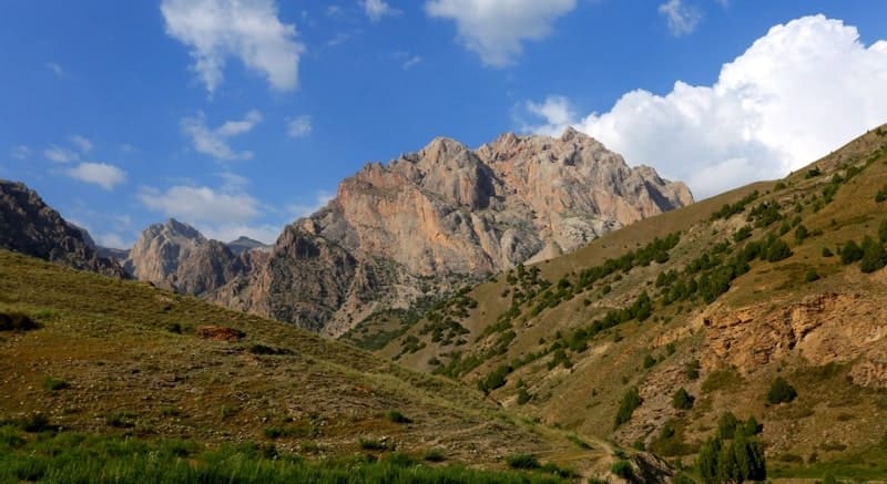
Peaks in Fany Mountains.
Climbing mountains in Tajikistan.
“Adieu to disappointment and spleen. What are men to rocks and mountains?”
Jane Austen. «Pride and Prejudice».
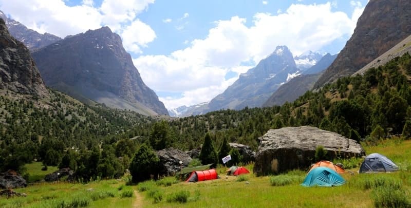
Climbing to Fany Mountains.
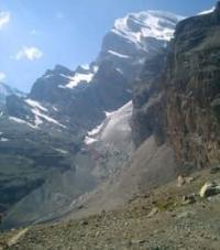
The Zeravshan ridge, stretching from the sources of the Yagnob in the east to the headwaters of the Sarymat and Karakul in the west, reaches the highest height in the Fany mountains. Here, the peak of Chimtarga with a height of 5489.7 meters above sea level - its highest point - rises into the sky with a sharp takeoff.
A powerful mountain knot is formed in this place. To the south of Chimtarga, in the Zeravshan ridge, the Energia peak rises with a height of 5120.1 meters above sea level. From it to the east, right up to the mouth of the Iskanderdarya river, the Eastern Fany ridge departs, in its eastern extremity bearing the name Zinakh.
The Eastern Fany ridge separates the Iskanderdarya basin from the Pasrud river basin. From the north, Chimtarga is adjacent to the Mirali peak with a height of 5106.1 meters above sea level. From it to the west there is a high, but relatively short Western Fany ridge, ending near the mouth of the Artuch River and separating the Artuchi basin from the Voru River basin.
Thus, we have four closed inner regions of the Fany Mountains: the Pasruda basin in the northeast, the Artuch basin in the northwest, the Boru basin in the southwest, and a basin with a drain to Lake Iskander-Kul and Iskanderdarya in the southeast.
Side spurs from these main guiding ridges have divided the area into a number of gorges and gorges. The largest of them are the northern spur of the East Fany ridge, extending from the Zamok peak, 5020 meters above sea level, and the southern spur of the same ridge, starting from the Bolshaya Hansa peak, 5306.8 meters above sea level.
In the northern spur, the peaks of the Fany Mountains are remarkable: - Bodkhona 5052.3 meters above sea level and Chapdara peak 5049 meters above sea level, in the southern spur - the summits of Krasnye Dawns 4744 meters above sea level and White Leopard 4506 meters above sea level.
In the East Fan Range, there are sequentially located, starting from Energiya, peaks over 4000 meters above sea level:
Peak Snake with a height of 4140 meters above sea level, Physical Culture and Sports with a height of 4120 meters above sea level, Gratuleta with a height of 4230 meters above sea level, Chinal with a spur Fagitar 4277 meters above sea level, Payhamber with a height of 4958 meters above sea level.
Peaks 5000 meters above sea level in the Fany Mountains:
Peak Castle 5020 meters above sea level, Black Peak 5010 meters above sea level, Malaya Hansa 5031 meters above sea level, Big Hansa 5036 meters above sea level.
To the peaks over 4000 meters in the Fany Mountains:
Fan-Ulla 4473 meters above sea level, Sarof 4517 meters above sea level, Ships 2408 meters above sea level, Zinah 4224 meters above sea level, Shome.
From the nodal summit Sarof in the Fany Mountains, spurs depart to the north and south:
to the north - Turzulsky with peaks Stupenka 4200 meters above sea level, Tower 4020 meters above sea level, Patrush, 4040 meters above sea level and Tangi, to the south - a short spur with a summit, Fingers 4142 meters above sea level.
In the Western Fany Ridge there are peaks:
Maria, 4790 meters above sea level, Aurondag 4600 meters above sea level, Saryshah 4565.5 meters above sea level, Gaznych 4170.5 meters above sea level.
In the Zeravshan ridge to the south of the Energia peak, there are the Rock Wall peaks with a height of 4734 meters above sea level, the Moscow peak at a height of 5200 meters above sea level, Sugar Loaf at a height of 4903 meters above sea level, Pushnovat at a height of 4600 meters above sea level, and then the ridge turns to the west and forms a powerful rocky-ice barrier of Dukdon with peaks up to 5000 meters above sea level.
To the north of the peak of Mirali, the Zeravshan ridge drops sharply, a number of easy passes pass through it. The ridge is experiencing a new uplift behind the gorge of the Pasrud River. Its indented ridge is crowned with rocky peaks; glaciation is insignificant.
Particularly sharp relief forms are observed over the lower reaches of the Yagnob. Eastern segment The Zeravshan ridge is composed of shale, its slopes are smoothed, only sometimes the Yagnob gorge is cut by spurs of hard rocks, and Yagnob burrows into a narrow canyon.
The peak of Neglёb stands out here for its sharp rocky outlines. In most cases, however, the peaks stretch in an even line with a little glaciation. Above the very top of Yagnob, there is a peak of 5016 meters above sea level, which is significantly higher in height than the general level of the ridge.
The region of Fany - Yagnob, bordering on the south, the Gissar ridge throughout the entire area has a significant height and developed glaciation. A large northern spur near the village of Margib comes close to the Yagnob gorge, forcing the river to go around it and cut itself a narrow gorge - a canyon.
Here the top of Zami-Karo rises like a frozen wave with a predatory sharp fang. Its glaciers descend low to the Margib village and to the other side, east of the Margib village. The gorge of the Anzob River, the left tributary of the Yagnob, leads to a depression in the Gissar ridge and to the Anzob pass, 3373 meters above sea level.
Further to the west, the Gissar and Zeravshan ranges bring their spurs together so closely that the Yagnob River laboriously squeezes through the sheer stone walls. Above the gorge of the Iskanderdarya River from the south rises a majestic ridge of snowy peaks of the Gissar ridge:
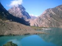
Peak Gaznok with a height of 4886.7 meters above sea level, Mokshevat and Khazor-Mech. These peaks are clearly visible in the cut of the Mokshevat river gorge when you approach Dzhidzhik. Over the southern shores of Lake Iskander-Kul, dominates the Dozhdemernaya peak, 3343 meters above sea level, or Kui-Chor-bai, well known for its rounded cap and steep slopes above the Sarytog River.
If you go up the gorge of the Mokshevat River, you can go to the Khoja-Iskhok cave and see his skeleton on the threshold, but the way there is difficult.
Above Lake Iskanderkul, above the Sarytoga valley, the rock towers and needles of the Kyrk-Shaitan peak, or Simob, 3900 meters above sea level, which in Tajik means mercury, always draw attention. Dozhmemernaya and Kyrk-Shaitan are only the northern spurs of the Gissar ridge. Its main peaks are hidden in the depths of the gorges.
A large mountain knot with numerous peaks, firns and glaciers is located in the upper reaches of the Aksu, Karakul and Sarymat rivers. According to rough estimates, there are up to 300 peaks in the Fann Mountains and Yagnob, in the Zeravshan and Gissar ranges.
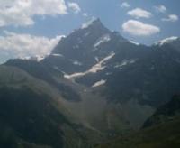
The mountains are one of the most attractive sights in the Fany Mountains. No traveler can forget Chimtarga, who proudly raised her head as a resting lioness. Chimtarga is best admired from the Kaznok pass or from the moraine of the Bodkhona glacier.
With good transparency of the air, it can be seen from afar from the Mapidor steppe, on the way from Penjikent. A magnificent view of Chimtarga and Bodhona opens from the Pasruda valley from the Bodhona kosh. Their peaks go so far into the sky, and the steep rocky-ice slopes are so steep that the peaks seem completely unreachable.
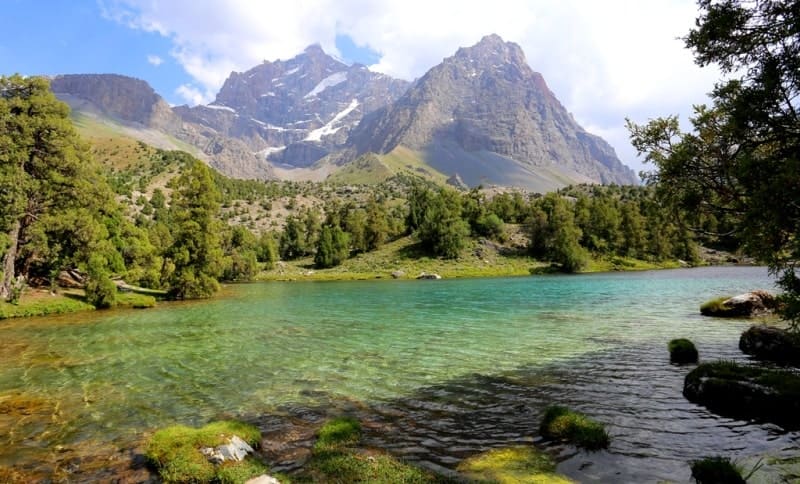
If you go deeper into the side wooded gorge, the northern wall of Chapdara, exceptional in height and inaccessibility, will open before your eyes. Chapdara dominates the Alaudin lakes, to which it faces with its northwestern wall.
From the same lakes you can admire the Adamtash peak, the eternal guardian of Alaudin. When climbing from the Alaudin lakes along the gorge, the black silhouette of the Fagitar peak opens up, and from the Mutnye lakes, a wide panorama of the mountain circus with the peaks Energia, Paykhaber, Snake unfolds.
The top of the Castle is exceptionally unique, making the impression of an artificial architectural structure. To admire the peaks of Moscow and Amshut, it is worth making a path along the Zindon gorge or climbing the Double South pass, 4200 meters above sea level.
An extensive view of the walls of the Western Fany Range and the peaks of Mirali, Aurondag, Saryshah opens from the Kulikalon Basin. The snow-toothed crown of the Big Hansa overshadows Lake Iskander-Kul from a distance.
A more extensive view of the Bolshaya and Malaya Hansa, as well as a significant part of the Eastern Fanн Range, opens from the slopes of the Double Severny Pass 4260 meters above sea level. Sugar Golova, Moscow and Skalnaya Stena are clearly visible from the Kaznok Vostochny pass with a height of 4101 meters above sea level, but due to a significant distance they do not make such a grandiose impression as up close.
Therefore, it is worth climbing the gorge of the Akhbasoy River, so that the Sugar Loaf appears in all its splendor. Fany-Ulla peaks with a height of 4473 meters above sea level and Sarof with a height of 4517 meters above sea level are best admired from the Turzul pass with a height of 3780 meters above sea level.
The first peak, which is met by travelers entering the Fany Mountains from Dushanbe, opens from the Yagnob gorge, from Rawat, this is the two-headed Shome, but its two heads can be seen only from Dzhidzhik, over which it dominates.
The same peak, but in the form of a stepped snow wall, can be observed from the mountain circus in the upper reaches of the Zinakh River. It is worth climbing here if only to see the inaccessible jagged colonnade of the Korablikov.
The best panorama of the Dukdon massif opens from the Ozerny pass 4080 meters above sea level. Dukdon glaciers are visible far below, and the entire southern part of the horizon is occupied by a sheer wall, sparkling with firns and ice, thundering with avalanches and rockfalls.


Authority:
"Fany Mountains and Yagnob". N.V. Paganuzzi. 1968. Moscow. Physical Culture and Sports Publishing House.
Photos by
Alexander Petrov.