


![]()
Вы здесь
Sardoba Malik.
Tours to Navoi region.
“I've known rivers:
I've known rivers ancient as the world and older than the flow of human blood in human veins. My soul has grown deep like the rivers”
Langston Hughes.
Historical monuments of Navoi region.
Sardoba Malik is located 49 meters south of the highway (M-37) Navoi - Bukhara, 3.3 kilometers west and slightly south of the village of Rabat Malik, 18.3 kilometers west and slightly north of the city of Navoi, 287 meters to the south-west of the Rabat-i Malik caravanserai in the Karmaninsky district of the Navoi region.
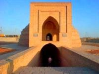
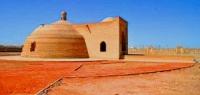
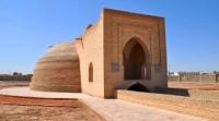
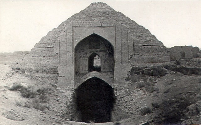
Sardoba Malik, was built in the 11th century to supply water to the Rabat-i Malik caravanserai. Technically, the sardoba is a 13 meter deep reservoir covered with a 12 meter diameter dome. The dome has three skylights. Currently, the entrance is a portal (recently added).
A ramp leads to the water from the portal. Sardoba was filled with water from the Zaravshan River through an underground channel - kyarizu, which had an exit to the surface by a network of wells. Sardoba (Iranian "serdabe", from "serd" - cold and "ab" - water) is a term denoting in Central Asia and some countries of the East: underground premises in medieval cities for shelter from the summer heat, storage of snow, ice, buried domed water tanks (usually on caravan roads, known from the Xth century) into the ground.
In areas of dense takyrs, during the rainy season or in spring, the practice of water conservation has existed since ancient times. Where rain and snow waters accumulated in a significant volume, natural reservoirs were fenced off with a not high clay duval (wall) in order to prevent water from overflowing over a larger territory.
In the process of improving the pits, they deepened more and more, and baked brick cladding was also used to fix their walls. This was the practice of creating open tanks. The domes gave the cisterns the shape of complete structures of the sardoba type.
Geographic coordinates of Sardoba Malik: N40 ° 07'16.37 "E65 ° 08'48.91"
Authority:
https://ru.wikipedia.org
Photos by
Alexander Petrov.