Вы здесь
Fortress Toprak kala Shavatskaya.

Photo tours to monuments of Karakalpakstan.
"The history of nations is a scale of human disasters, the divisions of which are designated by revolutions"
Francois Rene de Chateaubriand.
Excursions to main attractions of Karkalpakia.
The Toprak kala Shavatskaya fortress is located 2 kilometers north and slightly west of the Chokly village, 5.6 kilometers west and slightly north of the Saidyaz Arba village, 11.6 kilometers northwest of the Shavat town in the Shavat district of the Khorezm region.
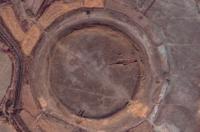
Fortress Toprak (Shavat), dates back to the II - I centuries BC. The walls of the fortress are originally made of rectangular mud bricks and have the shape of a regular circle. The shape of the building suggests a cult purpose of the building.
In subsequent periods, the walls of the structure were strengthened with pakhsa (compacted clay). Toprak kala (Shavatskaya), a little-studied archaeological site. The first excavations (excavations of several rooms inside the fortress) were carried out in 1979 - 1980 by Soviet archaeologists (Shahabad archaeological team of the Karakalpak branch of the Academy of Sciences of Uzbekistan) under the leadership of Mirzamurat Mambetullaev.
In 1980, in the layers of the second building horizon (II century BC - III century AD), paired clay figurines were found: a figurine depicting a horse (made of reddish clay of good firing, a red engobe was applied on the outside , dimensions: length - 11 cm, height - 7 cm), and a figurine with the body of a bull and a human head, presumably Gopatshah - a character of Iranian mythology (has a length of 10.6 cm, height - 8 cm).
t present, the archaeologists of the Khorezm Academy of Mamun (Khiva) and the Urgench State University (Urgench), senior researcher, are engaged in the study of Toprak-kala Shavat. B. Sadullaev and Ph.D. R. Abdirimov.
Geographic coordinates of the Toprak kala fortress (Shavatskaya): N41 ° 37'48.26 "E60 ° 04'32.45"
Authority:
http://life-on-earth.ru/srednyaya-aziya/toprak-kala-shavatskaya


