


![]()
Вы здесь
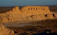
Ancient Settlement Zarlykishan bobo.
Tours to monuments of ancient Khorezm.
The overwhelming majority of the ruins received their present names many centuries after the life on them disappeared. The names of some of the ruins, like some of those listed above, are inspired by their appearance. The names of some of them remind the traveler of the formidable dangers that lie in wait for a person in the sandy sea scorched by the sun."
S.P. Tolstov. "Along the ancient deltas of the Oxus and Yaxart." Eastern literature. 1962.
Ancient Settlements of Khorezm region.
The ancient settlement Zarlykishan bobo is located in the central part of the Tashkent village, 10.2 kilometers to the east and slightly south of the regional center of Koshkupyr, 14.5 kilometers south-west of the city of Urgench in the Koshkupir district of the Khorezm region.
The ancient settlement Zarlykishan bobo, in the plan has an almost sub-rectangular shape with a side length of 207 x 239 meters, oriented with angles approximately along the cardinal points. The walls have survived in the form of swollen ramparts, 2 - 3 meters high and with separate elevations pointing to the places of the former towers.
There is a depression in the southwestern wall - the entrance to the fortress. Almost in the center of the monument, closer to the southeastern corner, are the remains of the citadel, which is an almost subrectangular hill 2.7 meters high and 60 x 70 meters in size.
Its corners are also oriented to the cardinal points. Around the hill are earthen elevations of various sizes and shapes, which are, obviously, the remains of various structures. The settlement is surrounded by a wide moat 1.4 - 2.1 meters deep. 250 meters northeast of the fortress, a rampart 17 - 20 meters wide and 6 - 7 meters high stretches from east to west for 300 meters.
The surface of the settlement is occupied by a cemetery and is covered with a plump salt marsh. There is little lifting material on the monument. The abundance of moisture and salts led to the complete destruction of ceramics on the surface.
In the modern Muslim burial pits we examined, a cultural layer emerges. To determine its thickness, a stratigraphic pit (2 x 2 meters) was laid in the eastern part of the site near the citadel. The pit passed through a 3-meter-thick cultural strata and reached the mainland, represented by gray sand.
Excavations were carried out in tiers of 0.5 meters each. Above the continent, a clayey layer with fine coal is traced, at the beginning of Stage VI - a dark gray clay layer with the inclusion of coals and fragments of ceramics.
The overlying layer stands out sharply in structure and content. It is light brown with lumps of clay. The layer contains fragments of ceramics and animal bones. At the beginning of the 4th tier, there is a layer of lumpy structure, greenish in color with a high content of charcoal and white salts. In some places, there is a sand layer 8 - 9 cm thick.
The finds are mainly represented by ceramics made from well elutriated dough with a yellowish engobe. At the end of Stage III, a dark gray layer with the inclusion of coals and ceramic fragments is visible. At the
eginning of the third and at the end of the second tier there is a uniform layer 48 - 82 cm thick with small coals and separate white spots.
Fragments of burnt bricks and fragments of gray pottery were found here. Between the II - IV tiers, in the southwestern section of the pit, there is a garbage pit filled with a greenish loose layer with the inclusion of coals, fragments of ceramics, as well as fragments of burnt bricks
A blue glass bead, a fragment of a smooth bronze bracelet, and fragments of glazed ceramics were found here. At the beginning of the second - lower half of the first tier, there is a gray lumpy layer with mixed fragments of burnt bricks, which occupied most of the pit area.
Above, the structure of the layer was disturbed by late burial pits. A fragment of a spherocone was found here. At the beginning of the first tier, there is a continuous alluvial and drip layer. In the lower layers of the pit, few ceramics were found, the fragments are inexpressive, represented by the walls of jugs and jugs.
The vessels are made of clay mixed with grit and chamotte. The fractured walls are brick-red and covered with a greenish engobe. There is a drawn wavy ornament on the walls of the khumchi. Vessels made of a similar clay dough and with similar ornamentation are characteristic of the ceramics of Khorezm in the VIIth - VIIIth centuries.
Ceramics of the IXth - XIth centuries concentrated in the V - III tiers of the pit. Fragments of yellow earthenware jugs and a hum wall with wavy ornament date back to this time. There are fragments of a jug with a wide longitudinal groove on the profiled side.
Among the glazed items, we note a fragment of a bowl covered with transparent glaze of light yellow color and decorated with a delicate engraved pattern. Materials from the upper layer of the tiers belong to the XII - XIV centuries. Tier II ceramics is represented by shelf-like rims of gray clay bowls.
The surfaces of the vessels are covered with dark gray engobe. Similar types of utensils are widely found in Khorezm settlements and ancient settlements of the XIIth - early XIIIth centuries. In the layers of the first tier, the lower part of a spherical cone and fragments of gray narrow-necked jugs were found.
In the upper part, the body of the jug is horizontally fluted; its surface is faced with a dark gray engobe. They are made from good gray dough. Such vessels are characteristic of the ceramics of Khorezm of the XII - XIV centuries.
Thus, the analysis of the material extracted from the pit shows that life on the site arose in the VIIth - VIIIth centuries. and lasted until the XIV century. Analysis of written sources allows us to establish the medieval name of the settlement.
Persian geographer Hamdallah Kazvini (born in 1281 - 1282) describes the route of the route connecting Merv with Khorezm (Kunya-Urgench). According to his report, “... From Khazarasp to the village of Azrak there are 9 farsakhs, then to Rakushmeisan (Ardahushmisan) there are 7 farsakhs”. Judging by these data, the distance between Khazarasp and Azrak is approximately 60 kilometers.
At such a distance to the west of the city of Khazarasp is the settlement of Zarlykishan bobo and from it at a distance of 7 farsakhs (42 kilometers) to the northwest on the direct road to Kunya-Urgench there is the settlement of Wayangan (I-XIV centuries), identified with the medieval the city of Ardahushmisan.
Therefore, it can be assumed that the settlement found in the spring of 1973 between Khazarasp and Ardahushmisan is the remains of the medieval village of Azrak mentioned in written sources.
Geographic coordinates of the settlement Zarlykishan bobo: N41 ° 30'54.29 "E60 ° 28'04.80"
Authority:
I. Mambetullaev. "Ancient settlement Kyat (Left-bank) and Zarlykishan bobo".
Photos by
Alexander Petrov.