


![]()
Вы здесь
Ancient settlement Gurganj (Urgench).
Cultural express tours around towns of Uzbekistan.
“... under the name Kangyuy, which is identical with the Kangkha of the Avesta, Khorezm is hiding. The very term "kangha", associated with the Iranian (and all-European) basis of "kan", whence the Uzbek and Tajik "kan" - a channel, and the word "channel" itself can be translated as "the country of irrigation ditches" or "Country of streams", delta; it is characteristic that the Helmand delta in Seistan is called Miyan-i-Kang; in the south-west of Khorezm, the southernmost channel of the Sarykamysh ancient delta of the Amu Darya still bears the name of Kangadarya, and the adjacent hill is the name of Kangagyr. " , german mouthpiece! (strait, ditch), English glanders! etc. are associated with the same term. And the term "kang" then simply meant "river", "channel"
S. P. Tolstov. "In the footsteps of the ancient Khorezm civilization" M. - L - 1948. p. 146.
Photos of Karakalpakstan.
Settlement of Gurganj (Urgench) is located in the southern part of the modern city of Kunya-Argench, 84.2 kilometers north-west of the city of Dashoguz, 27 kilometers south-west of the Uzbek city of Khojeil in the Keneurgench etrap of the Dashoguz velayat.
The settlement of Gurganj (Urgench), arose around the Vth century. BC. and existed until the 17th century. The time of the foundation of Gurganj has not been established. On the territory of the settlement, archaeologists have discovered a hearth of ancient settlements.
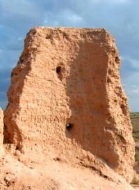
Excavations of the hill, known as Kirkmolla, have revealed the contours of a powerful ancient fortress, erected on an earlier cultural stratum with ceramics from the Vth - IInd centuries BC. There is no doubt that the original core of the city with powerful fortifications is located here.
This only confirms the assumption of academician S.P. Tolstov that it is Urgench in the transcription of Urva (or Urga) that is mentioned in the Avesta. The fact that people inhabited this territory in the 1st millennium BC is also evidenced by the Behistun inscription of King Darius I, in which Khorezm appears as one of twenty-three countries subject to the Achaemenids.
In the Chinese chronicles of the Han era (Ist century AD), there is also a message about Urgench in the Yue-gan transcription. The next mention, again in Chinese sources, refers to the VIIth century. During this period, the revival of Khorezm began, which returned life to the cities, where it froze back in the IVth century, these are the left-bank Kunyauaz, Izmykshir, Diyarbekir, Shahsenem, etc.
In 712, the whole of Khorezm was conquered by the Arabs, after which Gurganj began to be called Djurdjania in Arabic. It grew rapidly, as it occupied an advantageous position at the crossroads of trade routes from the south to the northwest - to the Volga River, and to the east - to Mongolia and China.
Under the Samanids, the capital of the region was the right-bank town of Kyat, where the local dynasty of Khorezmshahs ruled as vassals. In the left-bank part of Khorezm with the main city of Gurganj, governors appointed by the Samanids ruled.
Over time, they declared their possession independent from Kyat, which led to the separation of the north from the south. In 995, the emir of Gurganj al-Mamun ibn-Muhammad managed to conquer Kyat, overthrow the pre-Muslim dynasty, re-unite Khorezm and transfer the title of Khorezmshah to his own clan.
At the beginning of the 11th century, the reign of Mamun I, filled with formidable, bloody military events, long campaigns, complex political intrigues, after the short reign of his eldest son Ali ibn-Mamun, was replaced by a brilliant period of the reign of his other son Mamun ibn-Mamun.
It was under him that in Gurganj, which overshadowed the glory of Bukhara - the capital of the defeated Samanids, a unique circle of scientists of the court "Academy" of Mamun was formed. Its adornment was the great encyclopedist Abu Reikhan Mohammed ibn-Ahmed al-Biruni (973-1050) and the brilliant naturalist, physician and philosopher Abu Ali ibn Sina (980-1037), known in the West as Avicenna.
This prosperous period in the history of the city did not last long: the enlightened monarch Mamun II died in 1017, when Sultan Mahmud Ghaznevi conquered Khorezm, and a quarter of a century later the victorious Seljuks seize power over all the possessions of the Ghaznavids.
Since 1044, Khorezm is just a province of the Great Seljuk state. In 1097, an event took place that marked the beginning of the last (and brightest) dynasty of the Khorezmshahs-Anushteginids. The Seljukids appointed Qutb ad-din Muhammad I the ruler of Khorezm.
He ruled for 30 years and until his death was a loyal subject of Sultan Sanjar, who then, without hesitation, confirmed his son Atsiz on the throne of the Khorezmshahs by his decree.However, over time, the latter began to show independence, repeatedly entering into military confrontation with Sanjar.
Atsiz stubbornly and persistently pursued the policy of "collecting lands ”, from ancient times economically gravitating towards Khorezm, and gradually subjugated the entire north-western part of Central Asia. His grandson Tekesh ibn Il-Arslan finally liberated Khorezm from the Seljuks in 1194 and expanded his possessions to the size of a medieval empire.
Tekesh's son Ala-ad-din Mohammed II completed the formation of the state of the great Khorezmshahs, which reached the greatest power under him: it stretched from the northern regions of the Caspian Sea to the Persian Gulf and from the Caucasus to the Hindu Kush.
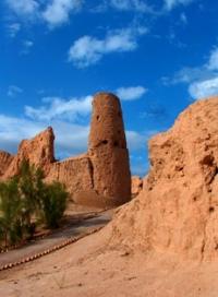
Throughout this brilliant period, Gurganj was an imperial center in which arts, crafts and trade flourished. Vivid traces of the Khorezmshah era remained on the Kunya-Urgench settlement in the form of archaeological and architectural monuments, among which, first of all, the unique tent-roofed mausoleums of Il-Arslan and Tekesh should be mentioned.
The pre-Mongol part of the city (Tash-kala) occupied the southern half of the settlement. The location of three of the four city gates has been established. Medieval authors write about the many quarters and two government palaces, about the amusement gardens in the vicinity, and about the large canal that crossed Gurganj.
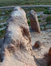
Almost no traces of them have remained, only in some places the heavily swollen walls of Tash Kala rise to a height of up to 5 meters. In 1221, after a six-month siege, the city was taken and destroyed by the Mongols. However, thanks to its convenient location, Gurganj, which the Mongols and Turks began to call Urgench, was able to revive relatively quickly and retain its importance as a trade, craft and administrative center.
Having become part of the Ucha Jochi, and then becoming almost independent in the system of the Zolotordyn Khanate, Khorezm entered a successful phase that lasted until Timur's campaigns. This is evidenced by Ibn Battuta, who arrived in Urgench in 1333 and called it the largest and most prosperous Turkic town.
The city was at this time the capital of the vast eastern province of the Golden Horde, and experienced the most brilliant period in its history. A special role in its development in the first half of the XIV century. Kutlug-Timuri was played by his wife Tyurabek-khanym.
Under their auspices, the restoration of the surviving monuments of pre-Mongol times was carried out, the minaret of the XIth century was completed (or underwent repair) at the namazga mosque, which became one of the highest in the world (about 60 meters), and a significant area was built up within the city wall, preserved in the form of a rampart up to 10 kilometers long, but now partially erased from the face of the earth.
It stretches to the north from the Ak-kala fortress, goes around the entire territory of the present reserve and turns south to the Khorezm bag fortress. The waters of the Amu Darya (Daryalyk Canal) flowed near the southern wall. After 1360, a Sufi dynasty, independent of the Golden Horde, settled in Urgench by this time, apparently, the process of the Turkization of the Khorezmian language had ended.
In 1388, a new disaster struck - Timur devastated Urgench, destroying most of the buildings and driving the remaining population to Samarkand. After this event, the city did not recover, although attempts to restore it took place in 1391 and much later.
But from the XVth century, processes of a global nature began, which did not contribute to the revival of the city.
- first, the channel of the Amu Darya changed and the river moved away from the city by almost 40 kilometers.
- secondly, the political and economic center of the region moved from Khorezm to Maverannahr (Samarkand and Bukhara regions).
Finally, the development of sea routes between Europe, India and China, as well as the discovery of America, led to the gradual disappearance of the transcontinental caravan trade and caused a general decline in the economy of Central Asia, which has since found itself on the periphery of world civilization.
Almost a century later, the general decline was aggravated by the complete dehydration of the surroundings and the population of Urgench had to leave their homes. In 1646 the Khiva Khan Abulgazi allowed them to settle 190 kilometers to the southeast, between Khiva and the main channel of the Amu Darya.
There the town of the same name was founded (until 1929 - Yangi-Urgench, i.e. New Urgench), now the administrative center of the Khorezm region of Uzbekistan. After that, almost nothing remained of the once great Gurganj, and its ruins have since become known as Old Urgench (Turkom. Köneurgenç).
Life began to return here after the Khan-yab (north of the mausoleum of Najm ad-din al-Kubr) was dug in 1831. A small rural-type settlement was formed on its shores, which became the basis of the present town. In the middle of the XIXth century, the Khiva Khan Mohammed Emin tried to move the capital of his state here from Khiva and even erected powerful walls of his fortification (Khorezm-bag) in place a suburban citadel presumably of the Golden Horde time.
Soon he died in a battle with the Turkmens, and his idea was abandoned. Kunya-Urgench began to develop only after the disappearance of the Khiva Khanate and the entry of the left-bank Khorezm into the Turkmen SSR in 1924.
In 1986, Kunya-Urgench, which was considered a settlement, received the status of a city. Now it is the administrative center of the Kunyaurgench etrap of the Dashoguz velayat.
Geographic coordinates of ancient settlement of Gurganj (Urgench): N42°18'18 E59°08'19
Authority:
Based on materials from the information department of the State Committee of Turkmenistan for Tourism and Sports. "Religious and Spiritual Monuments of Central Asia". Author M. Khashimov. Saga Publishing House, 2001
Photos by:
Alexander Petrov.