Вы здесь
Peak 100th anniversary (RGO).

Climbing to peaks of Meridional ridge.
“White all around, only snow and frozen stone.
Cold world - not a trace, not a haze.
The snow will sweep the snow in front of us,
And the hand is cold in a warm mitten."
Srym Kuderin. "Along the Glacier".
Tops of Meridional Ridge.
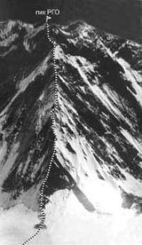
The peak of 100 years of the Russian Geographical Society (RGO) with a height of 6276 meters above sea level is located in the central part of the Meridional ridge, in its main ridge in the Narynkol district of the Almaty region.
The North Inylchek glacier, 41 kilometers long, descends along the western slope of the summit. 1.5 kilometers from the summit to the north, there is the Marble Wall peak, 6140 meters above sea level. At 3.7 kilometers to the south-west, there is the Vostochny Shater peak at a height of 6637 meters above sea level.
8 kilometers to the northwest is the Bayankol peak 5761 meters above sea level. The state border between the Republic of Kazakhstan and the Republic of China passes through the top and the crest of the ridge.
This is a three-headed peak, the eastern slopes, which are located on the territory of the Republic of China. One of the largest glaciers of the Central Tien Shan, Northern Inylchek, originates from the summit in the western direction.
The peak is named in honor of the centenary of the All-Russian Geographical Society.
From the history of the name of the peak Peak 100th anniversary (RGO).
It is known that Gottfried Merzbacher was the discoverer of a number of peaks of the Meridional Range. During an attempt to climb Khan-Tengri peak and explore the area in the Bayankol valley in 1902, Merzbacher named the mountain for a characteristic rocky cliff and a very steep snow-covered slope that closes in a semicircle for a kilometer the upper reaches of the glacier, which feeds the Sary-goinou river, the main source of the river Bayankol - The Marble Wall.
The mountain blocked the path to Khan Tengri, which he could not conquer. He named an even higher peak south of the Marble Wall after the Grand Duke Nikolai Mikhailovich Romanov - the patron saint of sciences, scientist historian and entomologist, who was at that time the chairman of the Russian Geographical Society.
Soviet cartographers pretended that the peak was named after the great traveler N.M. Przhevalsky. In 1946, the expedition of the All-Union Sports Committee under the leadership of A.A. Letaveta conquered the Marble Wall peak through the Pogranichnik peak.
The participants were awarded diplomas, and the peak of Nikolai Mikhailovich Romanov was renamed the peak of the 100th anniversary (RGO) in honor of the centenary of the founding of the Russian Geographical Society (1845).
In 1972, during the USSR championship in the class of high-altitude ascents, 3rd place was awarded for climbing the peak of 100 years of the Russian Geographical Society (RGO, 6350 meters above sea level along the western ridge, 5b category of difficulty.
The team of the Central Council of Voluntary Sports Society "Petrel" consisting of: Zhitenev F., Bakurov V., Kalmykov S., Krasnoukhov Y., Logachev Y., Lurie V., Pavlenko K., Stepanov I. (Leningrad).
Geographic coordinates of the peak of the 100th anniversary of the Russian Geographical Society: N42°14'10,56" E80°16'58,59"
Authority and photos by
http://www.alpklubspb.ru/priz/1972-4.htm
Alexander Petrov.


