


![]()
Вы здесь
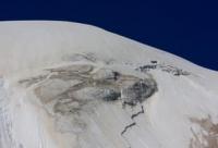
Teketor glacier in Ala-Acha gorge.
Tours to national natural park Ala-Archa.
“Here often with unprecedented longing
I thought, dreamed of you
Mists crept from the passes
Towards an unclear fate.
Guitar busting rang
And listened to them under the window
Oh mountains, oh blue mountains,
Peaks covered with ice."
Yuri Vizbor. 1956.
History of Ala-Archa park.
Teketor glacier, located on northern slope of Kyrgyz Ala-Too ridge, in lateral (eastern) Teketor gorge, belongs to Ala-Archa river basin, located 41 kilometers south and slightly west of city of Bishkek in Alamudun district of Chui region.
The sources of the glacier are located in the submeridional ridge, which stretches from the ridge of the Kyrgyz ridge for 9 kilometers. From the northern slope of Teketor Peak 4479.6 m. a. s. l., the Teketor Glacier slides to the north, from where its sources begin.
The length of the open part of the glacier is 2.4 kilometers. The length of the glacier moraine is 990 meters. The tongue of the open part of the Teketor glacier is located at an altitude of 3711 m. a. s. l. The tongue of the moraine part of the Teketor glacier is located at an altitude of 3372 m. a. s. l.
The perimeter of the glacier is 3141 meters, the area is 320491 sq. m. The glacier is located below the Topkaragai glacier. In the upper reaches of the glacier behind the eastern ridge there is one of the largest glaciers of the Kyrgyz ridge - Aksai with a length of 6.4 kilometers.
To the east of the glacier in the neighboring, eastern ridge of the ridge, which separates the Teketor valley from the Aksai valley, there is a massive Boks peak 4240 m. a. s. l. The headwaters of the Teketor River 2.4 kilometers long, which is the right tributary of the Ala-Archi, begin from the glacier.
Geographic coordinates of Teketor glacier: N42°30'57 E74°31'07
Authority and photos by:
Alexander Petrov.