


![]()
Вы здесь
Peak of Voennyh Topografov.
Climbing and mountaineering in Kyrgyzstan.
“Friends will remember those heights,
The ridges and walls of the peaks
Where adversity triumphed
Under your guidance."
Dombay. March 1960.
Climbing peak of Voennyh Topografov.
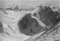
The peak of Voennyh Topografov, 6873 meters above sea level, is the third highest peak in the Central Tien Shan, located between the Meridionalny ridges in the east and Aktau in the west in the Ak-Suu district of the Issyk-Kul region.
10.2 kilometers to the west and slightly south of the Voennyh Topografov Peak is Pobeda Peak, 7439.3 meters above sea level. 3.9 kilometers to the north-east of the Voennyh Topografov Peak is the Rapasova (Bezymyannaya) peak, 6814 meters above sea level.
The peak can be seen only from the slopes of the Khan Tengri and Pobeda peaks and from an altitude of more than 5000 meters above sea level. In the southeast, at the tip of the North Kokshaal-Too ridge, the military topographers massif rises.
From the western shoulder of the massif to the north-west stretches a relatively short, but strongly glacial ridge Aktau. From the fork of the South Inylchek glacier, the summit resembles a fortress with white walls. The summit array is crowned with three towers.
The upper reaches of the South Inylchek glacier are rarely visited by climbers, this is due to the inaccessibility of the region and the harsh climatic conditions. The route from the upper reaches of the Zvezdochka glacier through the Chon-Teren pass has no technical difficulties and objective dangers.
The ascent can be made without preliminary acclimatization from the Chon Teren pass. The approach to the pass along the Zvezdochka glacier takes 2 days from the base camp "South Inylchek". The ascent to the pass along the icefall is not difficult.
From the slopes of the Voennyh Topografov Peak, a stunning view of the walls of the Pobeda Massif opens, and from the top - all the ridges, headed by the Khan Tengri pyramid. In 1958, a group of climbers led by I. Erokhin named the peak the peak of Voennyh Topografov in memory of the work of military topographers.
History of ascents to peak of Voennyh Topografov.
1958.
Making the traverse of Pobeda Peak, the climbers of the expedition of the MVTU-MSU sports clubs led by Igor Erokhin, explored the ridge of Eleven Peak (Eastern Victory), at the same time overlooking the path from the south-west to the Voennyh Topografov Peak.
The summit, where the expedition members climbed, was named the Western Voennyh Topografov Peak, 6816 meters above sea level. On this summit, the ridges from the Chonteren passes, 5488 meters above sea level, converge, located in the ridge of the Northern Kokshaal-Too ridge, and the High, 5730 meters above sea level, located in the southern part of the Aktau ridge.
On July 30, 16 of the most powerful climbers, led by Igor Erokhin, ascended the Chon-Teren saddle (5488 meters above sea level), where they replenished their food and equipment supplies, and then reached an altitude of 6200 meters above sea level.
The next day, it turned out that the western ridge was much more difficult than expected, and, despite the early exit, a high rate of ascent, only the first bunch of I.A. Erokhina, I. D. Bogacheva and A.K. Belopukhova.
The main peak remained unconquered. In the reporting materials of the expedition under the leadership of I. Erokhin, it was said about the first ascent to the Voennyh Topografov peak, 6873 meters above sea level, at that time in reality they climbed not to the Main, but only to the Western peak.
1965.
The main peak of Voennyh Topografov peak, 6873 meters above sea level, was first conquered in 1965 by a team of Kazakhstani climbers led by Aleksey Vododokhov from the upper reaches of the South Inylchek glacier along the north-western ridge, 5th category of difficulty.
During the ascent, three intermediate camps were established (the third camp was established at the High Pass). On August 14, the climbers climbed to the western peak of the Voennyh Topografov, while filming a note from the climbers of the MVTU-Moscow State University sports club, which was left in 1958 by the group of I. Erokhin.
August 15 climbed to the main peak of the Voennyh Topografov Peak The note of the first climbers from the summit was taken in 1988 by V. Khrishchaty and K. Valiev, during the traverse over the western shoulder of Pobeda peak: (ascent to Vazha Pshavela peak, 6 918 meters above sea level, through the Dikiy pass from the Zvezdochka glacier) - the main peak of the peak Pobeda (1.5 kilometer ridge at an altitude of 7439 meters above sea level) - Eastern Victory 7060 meters above sea level - Chon-Teren pass 5600 meters above sea level - Peak of Voennyh Topografov with a height of 6 873 meters above sea level as part of the USSR national team.
Geographic coordinates of Military Topographers Peak: N42 ° 03'07.26 "E80 ° 15'05.35"
Authority:
Alexander Petrov.
https://kantengri.kz/ru/tours/alpinizm/pik-voennykh-topografov
https://risk.ru
Photos by
https://risk.ru