


![]()
Вы здесь
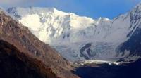
Meridional ridge in Kazakhstan.
Tourist trips in Kazakhstan.
"You and I will go to the mountains
To the blue passes
And to the heights of those from which
All misfortunes are just smoke."
Yuri Vizbor. 1962.
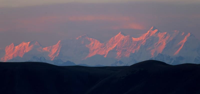
Mountains of Almaty region.
Meridional ridge is located in the eastern part of the Central Tien Shan, in the Raimbek district of the Almaty region. The state border of three states - the Kyrgyz Republic, the Republic of China and the Republic of Kazakhstan - runs along the main ridge of the Meridional ridge.
The northern, northwestern and western slopes of the ridge are located on the territory of Kazakhstan. On the territory of Kazakhstan, the North Inylchek glacier is located, for 11 kilometers flowing down from the western slopes of the Mramornaya Stena peak.
The eastern slopes of the ridge are located in the Republic of China. On the adjacent, eastern side of the ridge in China, there is the Karagyul glacier. The western slopes of the ridge from the latitudinal Tengri-Too ridge to the south are in the Kyrgyz Republic.
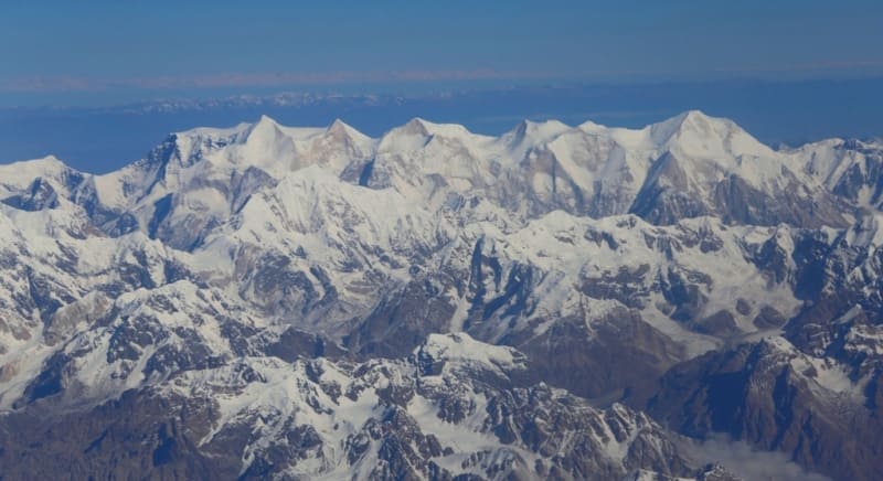
The length of the Meridional Ridge from south to north, across the territory of Kazakhstan, is 42 kilometers. All the ridges of the Central Tien Shan run in a latitudinal direction, the uniqueness of the Meridional Ridge in violation of this order is perpendicular to 90 degrees, which is why it got this name.
The Saryjaz ridge adjoins the western slopes of the Meridional ridge, north of the Tengri-Too ridge. The highest peak in the Saryjaz ridge is the Semyonov peak, 5816 meters above sea level. To the south of the North Inylchek glacier, the Tengri-Too latitudinal ridge with a length of 35 kilometers adjoins the Meridionalny.
In Tengri-Too, in its eastern part, there is the Khan-Tengri peak, 6995 meters above sea level and 7 more peaks above 6000 meters above sea level. The ridge begins in the north with a depression at the headwaters of two rivers - Bayankol in Kazakhstan and Maly Muzart in China.
Then it rises a step - more than 4000 meters above sea level, after which it goes to the central part - a step more than 6000 meters above sea level. The ridge ends on the territory of Kazakhstan, at the point of adjoining the western slopes of the Tengri-Too ridge.
State border between the Kyrgyz Republic and the Republic of Kazakhstan runs along the crest of the Tengri-Too ridge. The border is laid from east to west from the Vostochny peak at a height of 6637 meters above sea level, passes in the main ridge the West Shater peak at a height of 6511 meters above sea level, a peak at a height of 5901 meters above sea level, an elevation of 6041 meters above sea level and goes to the peak Khan-Tengri.
The length of the border from Shater Vostochny peak to Khan-Tengri peak is 8 kilometers. On the territory of Kazakhstan, in the Meridional Ridge, the highest peak is the peak of 100 years of the Russian Geographical Society with a height of 6276 meters above sea level.
In the central ridge of the Meridional ridge, there are ten peaks over 6,000 meters high. To the north of the central part of the Meridional Ridge, there is the northernmost six-thousander in the ridge - the Marble Wall peak, 6140 meters above sea level.
To the south of it there is a peak of 100 years of the Russian Geographical Society with a height of 6276 meters above sea level. In the central part of the Meridional Ridge, there is the Vostochny Shater Peak with a height of 6637 meters above sea level.
North of the Marble Wall peak, in the main ridge of the Meridional Range, there is the Plateau Peak 5850 meters above sea level. This is followed by Pogranichnik peak, 5100 meters above sea level, then Uzlovaya peak, 4910 meters above sea level.
Bayankol Vostochny glacier flows down from the western slopes of the ridge, at the source of which the Sarykoinou River begins, which is the main tributary of the Bayankol River. The meridional ridge is composed of metamorphic schists, marbled limestones, granites.
The foot of the ridge is covered with meadow-steppe vegetation. Tien Shan spruce forests are replaced at an altitude of 2800 meters above sea level with subalpine and alpine meadows. Nival landscapes are developed.
In the Meridional ridge, on the territory of Kazakhstan, there are several passes: Alaagyr with a height of 3870 meters above sea level (Alaaygyr river - Saikai river), Chinese with a height of 4001 meters above sea level (Marble wall glacier - Saikai glacier), Marble wall with a height of 5700 meters above sea level (Marble Wall glacier - Saykai glacier), Inylchek, 5500 meters above sea level.
Geographic coordinates of the Meridional Ridge: N42 ° 17'42.60 "E80 ° 15'32.93"

Authority:
Alexander Petrov.
IN AND. Ratsek, "Five Highest Peaks of the USSR", Publishing House "Uzbekistan", Tashkent, 1975.
https://www.tkg.org.ua/node/16333
Photos by
Alexander Petrov.