


![]()
Вы здесь
Upland Karabil.

Nature of Mary velayat.
“A vast, vague upland occupying the southern part of the Trans-Caspian region to the east of the Murghab River, near the Pendinsky oasis. Karabil goes generally to the east and northeast, separating to the north and south the secondary spurs and gentle ridges, separated by wide valleys, in which there are springs and wells (mostly salty). This upland, which rises in places up to 4,000 feet, is composed of clayey sandstones and covered with a thick layer of loess, which is covered by grass in early spring in March, which, however, burns out by the end of April.
In summer, the entire plateau, devoid of running water and occupying an area of up to 7 ½000 square kilometers with spurs, is a desert. In the valleys of the northern slope of the Karabil heights, there are numerous ruins and even the remains of the ancient city of Kishlag, showing that the area was previously inhabited. Through Karabil, a caravan road goes from Pend to Kerki on the Amu Darya, traversed only in spring, when there is feed for livestock and remaining puddles with rainwater."
V.M. Encyclopedic Dictionary of Brockhaus and Efron. "Karabil".
Natural sights of Mary velayat.
Karabil elevation is located east of the Murgab river, northeast of the Elashankyr mountains in the Tagtabazar etrap in the southeast of the Mary velayat. From the west, the elevation is limited by the valley of the Murghab River.
From the south, the elevation is limited by the northern slopes of the Paropamiz ridge and the state border of Turkmenistan and Iran. In the northeast, the border of the upland is the border with the Lebap velayat.
The Karabil Upland is located in the northern foothills of Parapapamiza. The area of the hill is about 20,000 square kilometers. Hilly-low-mountainous terrain prevails. The highest dominant elevation mark is Mount Daderanly, 984.4 meters above sea level.
Geographic coordinates of Mount Daderanly: N36 ° 13'21.87 "E63 ° 35'39.49"
The surface of the hill, folded by alluvial-proluvial fine-grained loess-like sandstones of the Neogene and early Anthropogenic age. The hill slopes from north to south. Typical are the landscapes of clay-like ephemeral deserts, half-deserted and sub-tropical, ephemero-like deserts ¬Pay.
rographically, the elevation is represented by the hilly foothills of Paropamiz, entering here from the south, with heights of 800 - 1000 meters above sea level. In the southern part of Karabil, in the relief, there are low hills, indented with ravines, in the northern part - ridges.
These areas are characterized by an ancient hydrographic network, which is directed to the north, where it merges with the ridge sands of the Southeastern Karakum Desert. The hills are composed of a series of continental deposits, which are combined into the so-called Karabil suite.
The origin of the deposits of this suite on the basis of their constituent rocks is considered proluvial and deluvial and attributed to the Pliocene. The soils of Karabil up to an altitude of 600 - 700 meters above sea level are represented by light sandy loam and light loamy non-saline and saline gray soils.
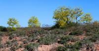
The vegetation is characterized by sedge-bluegrass communities with a predominance of sedge (Carex physodes C. pachystylis) and bluegrass (Poa bulbosa var. Vivipara), as well as partly ephemeral and wormwood.
Above 600 - 700 meters, common light loamy non-saline and solonchak gray soils are developed, which are used for rainfed agriculture in favorable conditions. It grows mainly ephemeral and sedge-bluegrass vegetation, in places with small shrubs.
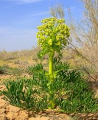
Not one pistachio tree grows in Karabil, and the woody vegetation is extremely poor, and is represented in small groups in the southern gorges of Karabil. In the vegetation cover of this strip, giant umbrella plants appear - ferula (Ferula bodrakema, F. Aitchisonii) - and rare pistachios from Pistacia vera. In the apical parts, dark serozems are widespread.
Karabil is extremely poor in water, apart from Murghab there are no rivers with a constant flow. In the southern part there are river beds, the water in which appears after heavy rains.
Geographic coordinates of Karabil Upland: N36 ° 22'40.93 "E63 ° 37'32.89"
Authority:
Alexander Petrov.
http://big-archive.ru
Photos by
Alexander Petrov.