


![]()
Вы здесь
Badkhyz Upland.
Nature of Turkmenistan.
"Land moved to the place of the sea and the sea to the place of land in ancient times ..., only a select few can delve into these phenomena."
Abu Reyhan Muhammad ibnAhmed al Biruni. Khorezm, 973. - Gazna, 1048.
Unique sights nature of Turkmenistan.
Badkhyz Upland is located in southern part of the Tejen and Murghab interfluves on territory of the Serhetebad etrap in the southeastern part of the Mary velayat and on the territory of the Serakh etrap in the south of the Akhal velayat.
Badkhyz is translated from Farsi as “the wind rises”. The location of the Badkhyz Upland is at the junction of the Turkmen-Khorasan Mountains and Paropamiz, in the area of the eastern foothills of the Kopetdag and the northwestern foothills of the Safedkokh ridge.
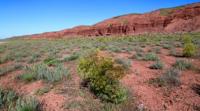
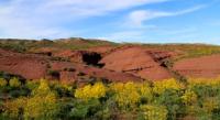
The landscapes of Badkhyz bear features close to the nature of flat deserts and arid heights of the temperate zone. Basically, this is a vast flat territory, but to the south the relief becomes more hilly, and on the border with Iran - low-mountainous.
There are small rocky ridges Danagermab and Gyazgedyk, the height of which does not reach 1300 meters above sea level. Badkhyz lowlands are composed of continental deposits of sandstones, sandy loams, and loams heavily eroded by weathering.
In some places there are igneous rocks, basalts and loose tuff breccias, of which, in particular, the "Monk" is composed in the Akar-Cheshme tract. The height of this natural landmark is exactly a finger, the rocks are about 30 meters.
Badkhyz is a semi-desert with ephemeral-ephemiroid and sedges and bluegrass vegetation. The highest point of Badkhyz is Yarylgankala mountain 1158.9 meters above sea level (Geographic coordinates of Yarylgankala mountain: N35 ° 46'46.40 "E61 ° 20'12.91").
The mountain is located in the southern part of the Gezgadyk ridge, in the vicinity of the ruins of Yarylgankal. Along the northern border of Badkhyz and in the drainless basins, there is a contact of mountain flora with the desert flora of the Turan province (Irano-Turan region).
Relief of Badkhyz.
The Badkhyz Upland is composed of layers of mainly sedimentary rocks - limestones, sandstones and siltstones. In places in the geological section and right on the surface, igneous rocks are found. Sedimentary rocks lie obliquely, rising to heights of 800 - 1200 meters above sea level in the southwestern part of the hill and gradually descending in the northeastern direction, where at the foot of the hill at an altitude of about 150-200 meters they are blocked by the sands of the Karakum Desert.
The modern relief of Badkhyz was created by three main groups of processes. First, the emergence of the mountain ranges of the Alpine-Himalayan belt in the Neo ¬ genus and their recent uplift in the Quaternary.
These powerful tectonic processes involved layers of sedimentary rocks in the uplift, tilted and partially crushed them, smashed by cracks. Erosion and deflation reworked the surface of the hills, created hills, valleys and depressions, clothed them with a thin, torn cover of sandy loam and loam.
Some forms of relief are composed of volcanic rocks, for example, a group of small hills - remnants. There are also relief forms in Badkhyz, created mainly by the wind. These are low sandy hillocks, sometimes similar to dunes, and elongated shallow depressions, not of wind, but of water-wind origin.
The same erosional-deflationary genesis is likely to be found in the huge deep basins in the southern and central parts of Badkhyz. In addition to wind and water, tectonics and hydrochemical destruction of rocks apparently contributed to their appearance.
The whole of Badkhyz is usually called the hilly highlands. But its appearance in different parts is very dissimilar - from almost flat to low-mountainous.
Climate of Badkhyz Upland is continental and hot. The average annual air temperature in Badkhyz is close to 15 °, while the average temperature in July is about 28 °, and in January - about 2 °. This does not mean, however, that there is no frost in Badkhyz.
They can occur there between the end of November and the end of March and often reach -20 °, although they usually continue a short time. Badkhyz receives an average of 280 mm of precipitation per year, mainly from mid-September to mid-April, with a maximum in January-March.
The rest of the months account for only an insignificant number of them. Summer is almost always dry here. Rains and sometimes snow come mainly in winter, with cyclones appearing on the Mediterranean branch of the polar front.
These so-called southern cyclones penetrate into Central Asia either between the Kopetdag and Paropamiz, or through the southern part of the Caspian Sea. Such incursions are usually preceded by dry southeasterly winds, often turning into dust storms.
During the passage of a cyclone, dry, warm tropical air entering its warm sector from the south or southwest also carries a lot of dust.
Winds blow in Badkhyz almost all year round. Westerly and southeasterly winds prevail, in terms of intensity and volume of transported air masses - northerly. Apparently, it is the northern air currents that create meridional aeolian landforms in Badkhyz and carry the bulk of the dusty material.
There are two main climatic seasons in Badkhyz - hot dry and cool wet. The first lasts approximately from May to September. The second, which includes a short warm autumn, a cool winter with short-term frosts, and a warm spring, lasts almost 7 months.
It is a mild and moderately humid season. Like any arid territory, Badkhyz is very poor in surface waters.
Hydrography of Badkhyz. There are no rivers in the reserve. Tejen and Kushka, enveloping the hill from the west and east, practically do not moisturize its territory and serve only as watering holes for large animals and resting places for some birds.
The left tributary of the Kushka, a small river Egrigek, which flows along the eastern edge of Badkhyz and also outside the reserve, carries salt water. The water of several lakes located in large basins in the central part of the upland is also very saturated with salts.
These lakes sometimes almost dry up, turning into salt marshes. The reserves of available groundwater in Badkhyz are small. Often these waters are highly mineralized and not drinkable. Few springs with fresh or slightly mineralized water are located mainly in the valleys and at the foot of the ramparts bordering large hollows.
All of them are used as watering places. There are also springs with salt water. Small lenses of groundwater by the spring can accumulate in the bottoms of the valleys, along which temporary streams flow after heavy rains and melting snow.
Badkhyz soils. The most common soils in Badkhyz, characteristic of hot, arid foothills, belong to the serozem type, while possessing some specific features. First of all, Badkhyz sierozem is less heavy, less clayey than classical.
This is probably due to both the composition of the parent rocks, the destruction of which is more sandy loam than loamy, and the development of processes of wind removal of small clay particles from the upper layer of loose sediments, in which soils are formed.
The lightweight mechanical composition of sero-soils also determines their good air and water permeability. The rains here deeply soak the soil and wash it out of soluble salts. Nevertheless, the properties common to sierozem are also decisive for the soils of Badkhyz - pale-yellow and gray, with a pinkish tint, with a small humus content, poorly differentiated on the horizons.
There are light, typical and dark gray soils with a humus content of up to 1.5%, from 1.5 to 2.5% and from 2.5 to 4.5%, respectively. All three subtypes of sierozem are confined to different landforms. So, on the driest and hottest southern slopes with the most oppressed vegetation, light gray soil is common.
On the least hot and well-humidified northern slopes, under the most productive vegetation, forming a closed sod, dark gray soils are formed. Flat watershed surfaces are usually occupied typical gray soils.
Flora of Badkhyz numbers more than 1000 species, including more than 60 endemic species and subspecies. The combination of the flora of these provinces determines the richness of the vegetation cover, in which more than 1100 species of vascular plants are known, including 696 species directly on the territory of the reserve.
On the Badkhyz Upland (within Turkmenistan) there are about 60 endemic species. On the territory of Badkhyz there is a relict pistachio savanna with century-old trees (including the endangered Badkhyz pistachio).
The main attractions of Badkhyz are two pistachio groves - Kushkinskaya and Pulikhatunskaya, with a total area of 75,000 hectares, as well as the drainless Yeroyulanduz depression 456 meters deep. he gray soil developed under the crowns of pistachio trees has a special character.
Pistachio is a long-lived tree: its average age is about 300 years. In late spring, summer and autumn, the dense crown of the tree, dropping almost to the ground, shades the soil well and prevents it from drying out.
Until the beginning of summer, under the crown of the pistachio, the herbage has time to grow magnificently. At the end of autumn, many fallen leaves accumulate there. Nuts also fall there, attracting many small mouse-like rodents, which arrange their burrows here.
Thus, in comparison with the soils of open herbaceous zones, crown soils are enriched in organic matter (due to the rich fall of fruits) and are well dug. They differ somewhat from neighboring soils and chemical composition.
These common soil features are found under mature trees growing both on watersheds and on various slopes. This is the powerful environmental forming role of pistachios. The second place in terms of prevalence belongs to salt marshes, the rest of the soils are found sporadically.
Populations of rare and endemic plant species grow (Afghan figs, Astragalus Vasilchenko, Astragalus Kushkin, Tulip Badkhyz, Tulip Leman). A distinctive feature of the flora of Badkhyz is the fact that an important floristic border of the Kopetdag-Khorasan province and the Central Asian mountain province passes here.
Fauna of Badkhyz is characterized by a combination of mountain, semi-desert and desert species. About 350 species of vertebrates and more than 1300 invertebrates, characteristic of the transitional zone of desert, semi-desert and arid low-mountain landscapes, live directly on the territory of the reserve.
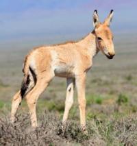
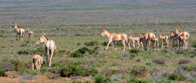
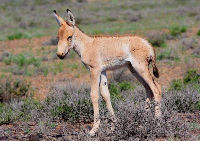
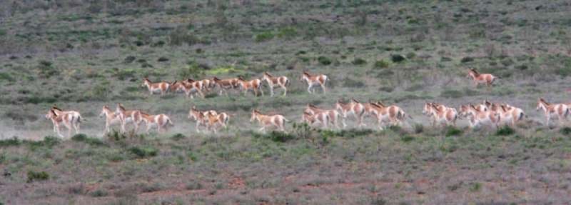
The fauna is rich and varied, but the most valuable protected species are wild ungulates. Among them there are endemics characteristic of Turkmenistan, and some of them for the southern neighboring countries and Central Asia - the Badkhyz ground beetle, the Kryzhanovsky nutcracker, the Badkhyz darkling beetle, the lumpy gecko, the Chernova snake lizard, the kulan.
Badkhyz is a territory where the world's only aboriginal population of the kulan, the relict Yeroylanduz population of the tuberous gecko, lives. Habitats that are decreasing in numbers are also protected: short-winged bolivaria, Central Asian cobra, Central Asian gyurza, burial ground, golden eagle, bearded man, red-headed falcon, little bustard, avdotka, shrike waxwings, honey badger, caracal, gazelle, mountain sheep, Indian porcupine.
Rare and endemic: burrowing grasshopper, Jacobson's golden beetle, hilly ant, pinkish madais, mesentine whitefish, long-legged gecko, Turkmen gecko, ocellated chalcid, common snake-eater, hawk eagle, black vulture, baloban beetle, laggar eagle owl, mouse-like hamster.
Little-studied species: the Trans-Caspian gloomy bear. Vulnerable species with low abundance: steppe kestrel. Endangered: white crane, beauty bustard, striped hyena, leopard. The invertebrate fauna includes more than 1326 species belonging to 6 classes, 22 orders and 134 families.
Of these, 1 species belongs to oligochaetes and jaw leeches, crustaceans - 6, arachnids - 148, centipedes - 3, diplopods - 1, insects - 1167 species. The arachnid fauna is dominated by spiders (7.7% of the total number of species), insects - coleoptera (42.6%).
Badkhyz is inhabited by more than 40 endemic and subendemic species of invertebrates, unknown outside the CIS or the Iranian-Afghan parts of the region, as well as a large number of species found in the CIS only in this region. Among the indicated groups of invertebrates, 771 species live in the Kushka valley, 399 species in the desert steppe, 590 in the pistachio woodland, and 314 invertebrate species in the drainless Yeroylanduz depression.
Badkhyz State Nature Reserve (87680 hectares), Pulikhatum Reserve (15000 hectares), Kyzyljar Reserve (30,000 hectares), Chemenabid Reserve (12000 hectares) operate within the boundaries of Badkhyz. The total area is 144680 hectares, which is more than 10% of Badkhyz and less than 5% of the entire landfill.
Most of the territory is pasture (the best in Turkmenistan). Agriculture is developed insignificantly in the valleys of the Kushka and Murgab rivers. The region is actively exploring and developing gas condensate fields, there are reserves of alunite.
Geographic coordinates of Badkhyz Upland: N35 ° 47'10.17 "E61 ° 31'01.52"
Authority:
«Econet of Turkmenistan». Lukarevsky V.S. - expert on protected areas and large mammals, Berkeliev T. - expert on threats to biodiversity.
Photos by
Alexander Petrov.