


![]()
Вы здесь
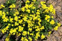
Zhalanash valley.
.")
Sights nature of Kazakhstan.
"June 13, 1856. We ascended northwest over a small (exposed) ridge and, having passed the headwaters of the Chilik River at its very bend from west to north, ascended the flat, mountainous Dzhalanach, which makes a convenient summer camp - a jailau. Climbing this mountain is impossible on wheels due to its steepness."
Chokan Valikhanov. "Diary of a Trip to Issyk-Kul." 1856.
"On June 5th, we left our overnight camp on the southern slope of Turaigyr at 8 a.m. and by midday had descended to the Dzhalanash plateau, where the labyrinth of three rivers - the Merke (Uch-Merke), Kegen, and Charyn - was already familiar to me from 1856. The plateau had sandy-clayey soil, partly strewn with boulders and rock fragments, but still more fertile than the plateau separating the foot of Seyrektash from Turaigyr. There was no forest vegetation at all on the southern slope of Turaigyr, but the mountains rising beyond the Charyn River were covered with forest. Having descended to the plateau, we stopped for a rest around midday and made a hypsometric determination here, which gave us an absolute altitude of 1,430 meters. The weather was clear, the Celsius thermometer showed +19°.
P. P. Semenov-Tyan-Shansky. "Journey to Tien-Shan." 1856-1857.
"This crevice in the rocks, at the bottom of which flows the Kechen, known here as Aktogoya, and below it the Charyn, is 300 to 500 meters deep, and its walls are sheer in places. The area between the Charyn and Chilik rivers consists of elevated steppe, known as the Dzhalanash plateau, which, at an altitude of 1,200 meters, stands out sharply from the surrounding mountains in its lack of tree vegetation and the paucity of fauna."
"Volosts and Settlements of Semirechye Region." Issue 7. 1893.
"Unfortunately, I could not measure the level of Chilik, since the barometer tube broke here, but I think it is about 4,000 feet. This is how P. P. Semenov estimates the height of the Dzhalanash plateau, between both ridges of the Trans-Ili Alatau, onto which the Chilik flows from its mountain valley. This plateau is a wide steppe plain with very sparse vegetation, in the middle of which there is a deepening, delimited by low but steep granite outskirts, a fairly wide valley of Chilik, with sparsely growing but huge poplars, dense thickets of sea buckthorn, willow, barberry and luxurious meadows {At Chilik, Arvicola sp. was collected; of the birds, Accentor atrogularis was collected and Aquila imperialis was seen; On the fly, a Falco sacer (a saker falcon) perched in a tree, examined in detail through a spotting scope but not allowed to get within shooting distance; Falco subbuteo, generally birds of the foothills.}. Having reached the eastern edge of the valley on the 21st, we walked along the granite Dzhalanash, and after about six miles, along a gentle escarpment, we ascended the similarly steppe plateau of Uch-merke, whose name means Tri-merke, since it is intersected by three rivers of that name, which flow into the Charyn River, the largest tributary of the Ili.
"Journey through Turkestan Region and Exploration of Mountainous Country of Tien-Shan." N. Severtsov. St. Petersburg. 1873.
Trip to Zhalanash valley from Almaty.
Zhalanash valley is located in northern spurs of eastern part of Kungei Alatau ridge, in southern part of Toraygyr mountains, in north and northwest of floodplain valley of Charyn River in Raiymbek district of Almaty region.
The area of the Zhalanash valley is 532.35 square kilometers, the perimeter of the valley is 115.55 kilometers. The valley stretches for 25 kilometers from west to east from the village of Togyzbulak to the Kopaly valley. Width, in the central part reaches 19 kilometers.
The southern borders of the valley are the Togyzbulak valley located on the northern slopes of the Kungei Alatau ridge, the valley of the Shet-Merke River, which is the left tributary of the Kegen River. From the mouth of this river Kegen gets a new name - Charyn.
The eastern border of the Zhalanash valley is the valley of the Charyn River, which stretches from south to northeast for 20 kilometers. In the floodplain of the Charyn River, in its western part, along its entire length, there is the Aktogay valley, in the eastern part of the floodplain - the Zhalasay valley.
In the northern part, the valley is crossed from east to southwest by the Chilik-Algabas highway, 26 kilometers long in this section. Approximately in the middle part of the road there is a branch to the village of Zhalanash with a length of 19 kilometers.
To the north of the valley are the southern slopes of the Toraigyr mountains, to the northwest is the valley of the Chilik River. The height in the eastern part of the valley in the vicinity of the Kopala tract is 1325.3 meters above sea level.
The height in the southern part of the valley in the vicinity of the Togyzbulak valley is 1863.2 meters above sea level. In the north of the valley, the heights reach 1618.2 meters above sea level.
Geographic coordinates of Zhalanash valley: N43°09'45.38" E78°42'41.94"


Authority and photos by:
Alexander Petrov.