Вы здесь
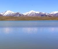
Lake Kutyrgan-Bulak Ontustik.

Photo tours in mountains of Dzungarsky Alatau.
"Man does not become the master of nature until he has become the master of himself."
Georg Hegel.
Trip to Dzungarsky Alatau.
Moraine, flowing lake Kutyrgan-Bulak Ontustik is located in the upper reaches of the river of the same name at an altitude of 3178 meters above sea level, on the northern slope of the Toksanbay ridge in the southwestern part of the Dzhungar Alatau mountains in the Eskeldin district of the Almaty region.
On the northern slope of the Kazan gorge, in the upper reaches of the Shygys Kuturgan-Bulak river, there is a lake of the same name. The length of the lake from west to east is 238 meters, the largest width in the central part of the lake is 180 meters.
The area of the lake is 34947 square meters, the perimeter is 811 meters. In the upper reaches of the lake there is a glacier with a length of 1.3 kilometers. The area of the glacier is 1.04 square kilometers, the perimeter is 4.51 kilometers.
The upper limit of the glacier is located at an altitude of 3731 meters above sea level. The tongue of the glacier is located at an altitude of 3282 meters above sea level. A stream flows from the lake, which flows to the beginning of the main channel of the Shygys Kuturgan-Bulak for 1.8 kilometers.
The total length of the river is 7.6 kilometers. The main channel of the Kutyrgan-Bulak Ontustik River is located at an altitude of 2991 meters above sea level. It is formed from two tributaries: Shygys and Batys Kutyrgan-Bulak.
In the upper reaches of the tributary of the Batys Kuturgan-Bulak, there is a lake of the same name at an altitude of 3246 meters above sea level. The length of the lake from southwest to northeast is 224 meters, the largest width in the central part of the lake is 67 meters.
The area of the lake is 11944 square meters, the perimeter is 504 meters. In the upper reaches of the lake there is a glacier with a length of 1.3 kilometers. The area of the glacier is 626013 square meters, the perimeter is 3570 meters.
The upper limit of the glacier is located at an altitude of 3809 meters above sea level. The tongue of the glacier is located at an altitude of 3246 meters above sea level. The mouth of the Kutyrgan-Bulak Ontustik River is located at an altitude of 2311 meters above sea level.
Geographical coordinates of lake Shygys Kuturgan-Bulak: N44°45'01.76" E79°45'25.57"
Geographic coordinates of Lake Batys Kuturgan-Bulak: N44°44'50.09" E79°44'18.21"
Authority and photos by
Alexander Petrov.


