


![]()
Вы здесь
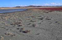
Geology and relief of Khazar Reserve.
Ecological tours in nature of Turkmenistan.
"Salt of the desires of the people,
I loved the pain of dreams.
Moon rose in heaven
I loved the ocean.
Nightingale - and noise and quarrels
I fell in love in Gulistan;
A whirlwind of a heavy scythe,
As in a dope, I fell in love;
The steppe has bewitched me;
I loved the way of wandering."
"The Wanderer in Love" Translation by A. Tarkovsky. Makhtumkuli.
Physical and geographical features of Khazar Reserve.
Land landscapes in the Krasnovodsk area are represented by low sandy islands and spits with halophilic vegetation, coastal sandy desert in combination with sandy solonchaks, and small remnant hills. The basis of the hydrological network in Gasan-Kuli is Atrek with floodplain reservoirs.
The river originates in the Kopetdag and brings its waters to the Caspian Sea only during the flood period. In recent years, due to the development of irrigated agriculture in the Atrek basin, the water content of the river has decreased even more, and the flood regime has been disturbed.
As a result, the lake dried up. B. Delili, which is currently artificially watered. On the other hand, due to the rise in the level of the Caspian Sea, a change in the coastline is inevitable in both parts of the reserve, most significantly in the Khazar Bay, where the Krasnovodskaya Spit - Osushnye Islands system will be partially flooded, and the Cheleken Peninsula will again turn into an island.
Good warming, shallow depths, an abundance of shoals and islands contribute to the development of underwater vegetation, aquatic invertebrates and an abundance of birds here. In addition to biotic objects preserved on the territory of the reserve, there are other unique creations of nature.
First of all, these are numerous geological formations: mud hills, springs with salty waters, oil and gas outcrops, “kyr” surfaces (areas with the spread of bizarre forms of sand weathering, cemented by oil), etc. The richest of such objects mi peninsulas Cheleken, they are in the vicinity of Chakichler and in other areas.
According to the scheme of physical and geographical zoning of Central Asia, the reserve is included in the region of desert remnant hills of Western Turkmenistan, the middle subzone of the Turan country. The natural complexes of the land part of all sections of the reserve are represented by desert landscapes and dry subtropics.
The water area of the reserve is exceptionally representative as landscapes of sea bays and shallow waters of the South-Eastern and Eastern Caspian. In the Esenkuli area, reference areas of the landscapes of the south of the Caspian Sea with fragments of forests and floodplain vegetation of dry subtropics are preserved.
The uniqueness of landscapes with an exceptional diversity and abundance of birds was formed in the conditions of the ancient deltas of the Amudarya and Atrek rivers. A significant area in the Esenkuli site is occupied by the Atrek floodplain, which includes the floods of the system of lakes Small and Big Delili.
These intrazonal landscapes have always been typical for the rivers of southern Turkmenistan. Due to the relatively good preservation of the natural complex and against the background of modern processes of desertification and degradation of the surrounding landscapes, these floodplain ecosystems become unique.
The landscapes of sea bays, shallow waters and other (including freshwater) water areas are most typical for the reserve, occupying about 80% of the protected area. On the By the middle of 1997, the total area of water areas was 220,000 hectares, of which 66% fell on the share of Turkmenbashi (formerly Krasnovodsk) Bay, 17% of Balkhansky, 12% of North Chelekensky, 5% of Mikhailovsky, i.e. increased by more than 1.5 times since the beginning of the transgression.
Relief of the wetlands of Khazar Reserve includes 3 components:
- shallow brackish bays, open to each other and separated from the sea by spits,
- sand and shell spits, islands, marches overgrown with halophytes, - rocky islands in the Balkhan Bay.
- the modern transgression of the Caspian has led to an increase in the area of this system, the biocenoses of the previously dried up Mikhailovsky and Balkhansky bays have been restored, and unidirectional processes are taking place.
The area has a complex geological history, which is reflected in the wide range of underlying rocks - from the Middle Paleozoic to the Neogene and Quaternary. Paleozoic and Mesozoic (Jurassic and there are outcrops of Paleozoic igneous rocks.
A quarry for the extraction of these rocks adjoins the reserve, creating certain inconveniences (disturbance factor, dust, etc.). The main role in tectonics is played by sublatitudinal shear faults and thrust zones associated with the northward movement of microplates of the Arabian Peninsula - Iran - Hindustan, the activity of tectonics is confirmed by the high seismicity of the region (9 - 10 point zone).
In the southern part of the territory (Esenguly site), medium earthquakes, groundwater discharge, etc. Oil fields are localized mainly to the east and south of the Khazar section of the reserve, gas and oil and gas fields - to the east of the Esenguly section.
Geographical coordinates of Khazar Reserve: N37°39'57.59" E53°52'40.54"
Authority:
"Reserves of Central Asia and Kazakhstan". Under the general editorship of R.V. Yashchenko. Tethys edition. Editorial Board of the Scientific Society "Tethys": R.Ya. Yashchenko chairman), O.V. Belyalov, V.P. Krivenko, O.E. Lopatin, I.V. Mitrofanov, K.M. Pachikin. Marmazinskaya N. July 25, 2006. Berkeliev T. http://iucnca.net
Photos by
Alexander Petrov.