


![]()
Вы здесь
Southern Cheleken Foreland.
Rest on Caspian Sea in Turkmenistan.
"Love and the sea have no bottom,
I had to burn in immeasurable passion.
Plays with the heart, like a chip wave,
I had to overcome the madness of the waves."
"I had to." Translation by T. Streshneva. Makhtumkuli.
Turkmenistan - Travel Guide.
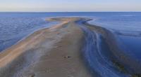
South Cheleken Foreland is located in the eastern part of the Caspian Sea, it starts from the southern tip of the Dervshi Peninsula, in the east it is washed by the waters of the South Cheleken Bay, the southern part of the spit borders the waters of the Cheleken-Ogurcha Strait in Balkanabat Velayat.
The length of the South Cheleken Foreland it from the southern tip of the Dervish Peninsula to the southern tip of the spit is 15 kilometers. The greatest width of the spit in the northern part reaches 4 kilometers, in the southern part up to 1.7 kilometers.
The narrowest part of the Foreland is located in the middle part with a length of 850 meters. For almost 4 kilometers in the southern part of the Foreland there is a lake, which is connected by a small channel about 70 meters wide with the waters of the Cheleken-Ogurchinsky Foreland.
For 3.8 kilometers along the northwestern part of the Foreland there are sands of a reddish hue. Heights in the southern part of the Foreland range from - 20.9 to - 26.6 meters, in the northern part of the Foreland from - 13.7 to - 27 meters. The mark of -13.7 meters is the lowest on the South Cheleken Foreland.
The narrow sandy extremity has an irregular shape - wide at the base and at the end and narrow in the central part. Under the influence of currents carrying bottom sandy material, the Foreland continuously builds up, moving more and more to the south. On its surface there are low sand mounds.
Geographic coordinates of South Cheleken Foreland: N39°17'35.42" E53°10'19.06"
Authority
Alexander Petrov.
http://www.caspianmonitoring.ru/
Photos by
Alexander Petrov.