


![]()
Вы здесь
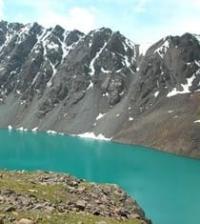
Lake Petrov in Ak-Shyirak ridge.
Tours in Ak-Shyirak mountains.
"The forces of the untamed nature - wind, clouds, storm and cold - find their strongest expression on the tops of mountains, endowing the heights with the aura of wilderness at its most extreme and undisturbed state."
Bernbaum Edwin.
Alpine lakes in Ak-Shyirak ridge.
The flowing, fresh, moraine Petrov Lake is located at an altitude of 3730 meters above sea level, located 44.3 kilometers east of the Barskoon pass, on the northwestern slope of the Ak-Shyirak ridge in the Jety-Oguz district of the Issyk-Kul region.
The length of the lake from north to south is 2 kilometers, the largest width in the northern part of the lake is 2.7 kilometers. The area of the lake is 4.57 square kilometers, the perimeter is 10.02 kilometers. The main filling of the lake comes from glaciers:
- Petrov East with a length of 13.6 kilometers, an area of 24.3 square kilometers, a perimeter of 31.48. The upper limit of the glacier is located at an altitude of 5100 meters above sea level,
- Petrov West with a length of 11 kilometers, an area of 26.55 square kilometers, a perimeter of 36.51. The upper limit of the glacier is located at an altitude of 4916.8 meters above sea level,
- Petrov North with a length of 6.8 kilometers, an area of 15.39 square kilometers, a perimeter of 27.8. The upper limit of the glacier is located at an altitude of 4800 meters above sea level,
- from two glaciers Sarytor Yuzhny with a length of 2.3 kilometers each.
From the western side of Petrov Lake flows the Kumtor River, 32.5 kilometers long. The river receives its main source from Lake Petrov, located at an altitude of 3730 meters above sea level. The main channel of the river is formed at an altitude of 3625 meters above sea level, almost 9 kilometers west of Petrov Lake from the confluence of the Arabel River on the right.
At 4 kilometers to the left, the river receives a tributary Lysy, which flows from the glacier of the same name. At 9 km after the headwaters, the river flows through the economic part of the Kumtor mine. For 13 kilometers, the Sarytor tributary flows into the river on the left, which originates from two glaciers: the Western Sarytor with a length of 3.9 kilometers and the Sarytor Eastern glacier with a length of 3.6 kilometers.
At the 18th kilometer after the sources, Kumtor receives the Bordu North tributary from the right, at the 24th kilometer the river receives the Bordu South tributary from the left, and here the Akbel tributary adjoins. The mouth of the river is located at an altitude of 3346.3 meters above sea level.
5 kilometers southwest of the lake is the largest, high-altitude, gold-ore deposit in Central Asia - Kumtor (Kyrg. Kumtor). The deposit is the second high-altitude gold mine in the world, second only to the Yanacocha gold deposit in Peru in terms of height.
The mine has been producing gold since 1997. The Kumtor gold deposit was discovered in 1978.
Geographic coordinates of Petrov Lake: N41°54'17.07" E78°13'35.38"
Authority and photos by
Alexander Petrov.