


![]()
Вы здесь
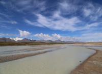
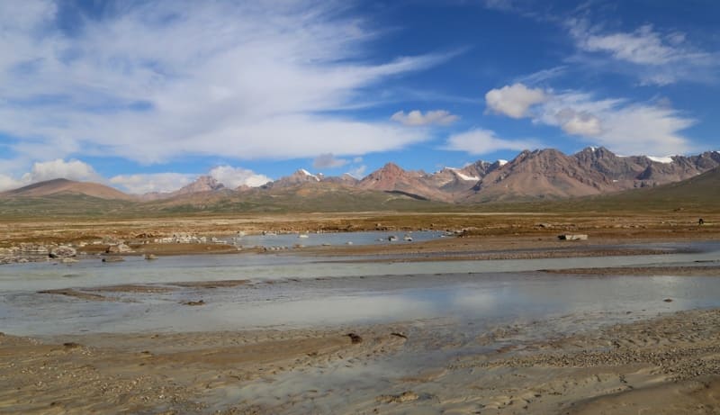
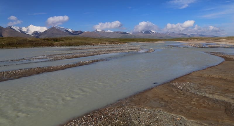
Karasai River in Ak-Shyirak Range.
Adventure travel in Kyrgystan mountains.
Travel is a book. Only those who can read between the lines of observed life can read it. The one who is looking for the original, the exotic, is set "poetically", inevitably falls into error, because in normal conditions of life he is looking for the abnormal.
"Years of searching in Asia". EM. Murzaev.
Mountain rivers of Kyrgyzstan.
Karasai River originates from the southern slopes of the Ak-Shyirak ridge, is the left tributary of the Naryn River, is located to the north of the Borkoldoy ridge in the Jetyoguz district of the Issyk-Kul region.
Karasai river basin consists of the following rivers: right tributaries - Kyrkoo-Su, Kyrgakkor, Kyrkol, Kundai, Achiktashtor, Tarasu, left tributaries - Egiztor, Ashu-Su, Kentor, Cholkotor, Sarytor.
5.7 kilometers after the formation of the main channel of the Naryn River (flowing to the right of the Jamanechka tributary), the Karasai River, 57 kilometers long, flows to the left. The Karasai River originates on the southern slopes of the Ak-Shyirak ridge from the largest Karasai glacier.
The length of the glacier is 9.1 kilometers, the area reaches 36 square kilometers, the perimeter of the glacier is 44 kilometers. The upper part of the glacier is located at an altitude of 4665 meters above sea level. The tongue of the glacier is located at an altitude of 3871 meters above sea level.
500 meters below the tongue of the glacier, at an altitude of 3790 meters above sea level, there is a moraine lake Karasai. The length of the lake is 1.9 kilometers, the largest width in the central part reaches 480 meters.
The area of Lake Karasai is 0.97 square kilometers, the perimeter of the lake is 5.83 kilometers. The Karasai River flows out of the southeastern part of the lake. On the eastern slope of the spur, in the western part of the lake, there is the eastern Akbel glacier, 3.1 kilometers long.
From the western slope of the southeastern spur of the Ak-Shyirak ridge, east of Lake Karasai on the left, Karasai receives a tributary that originates from the East Karasai glacier with a length of . 6.1 kilometers. The area of the Karasai East glacier is 8.17 square kilometers, the perimeter reaches 17.57 kilometers.
The upper limit of the glacier lies at an altitude of 4983 meters above sea level. The tongue of the glacier is located at an altitude of 3871 meters above sea level. From the western slope of the Koendy pass, 4327 meters above sea level, a tributary flows down to the Karasai on the left, which originates from the Koendy glacier, 2.5 kilometers long.
The area of the Koendy glacier is 2.58 square kilometers, the perimeter is 6.6 kilometers. South-west of Lake Pater-Bashik, the valley of the Karasai River expands and for 27 kilometers the river slowly flows until it flows into the Naryn River.
In the lower reaches, the river receives tributaries from the left, from the northern slopes of the Borkoldoy ridge. In the Karasai tract, to the west of the Karasai border outpost, due to the flat terrain, the Karasai River branches into numerous channels and flows into the Naryn River in two branches.
In the middle part of the Karasai River, southwest of the Karageru tract, there is a closed lake Pater-Bashik, located at an altitude of 3598 meters above sea level. The length of Lake Pater-Bashtk from southwest to northeast is 2.4 kilometers, the width of the lake in the eastern part is 750 meters.
The area of the lake is 1.15 square kilometers, the perimeter is 5.63 kilometers, the catchment area is 8.2 square kilometers, and the depth is 4 meters.
Geographical coordinates of Karasai River: N41°42'16.47" E78°10'10.01"
Right tributaries of Karasay River.
Kyrkoo-Su river.
Kyrkoo-Su river basin includes: Kurgakkoo, Kyrkoo rivers. At 51 kilometers after the sources, the Kyrkoo-Su tributary, 21 kilometers long, flows into Karasai on the right. The main channel of the Kyrkoo-Su River is formed at an altitude of 3353.7 meters above sea level.
The sources of the river are located on the northern slopes of the Beletek pass located at an altitude of 3735.9 meters above sea level and on the northern slopes of Mount Kurgakkoo with a height of 3805.9 meters above sea level. The mouth of the river is located at an altitude of 3285 meters above sea level.
Geographic coordinates of Kyrkoo-Su River: N41°35'58.12" E77°49'57.52"
Kirkoo river.
At the 12th kilometer after the beginning of the headwaters, a tributary of the Kyrkoo with a length of 12 kilometers flows into the Kyrkoo-Su River. The sources of the river are located on the northern slopes of the Beletek pass located at an altitude of 3735.9 meters above sea level and from the northern slopes of Mount Kurgakkoo with a height of 3805.9 meters above sea level. The mouth of the river is located at an altitude of 3353.7 meters above sea level.
Geographical coordinates of Kirkoo River: N41°38'29.18" E77°52'10.38"
Kurgakkoo river.
At the 12th kilometer after the beginning of the sources, the Kurgakoo tributary, 6.7 kilometers long, flows into the Kyrkoo-Su River. The sources of the river are located on the northern slopes of Mount Kurgakkoo with a height of 3805.9 meters above sea level and on the western slopes of an unnamed peak with a height of 3787.5 meters above sea level. The mouth of the river is located at an altitude of 3353.7 meters above sea level.
Geographic coordinates of Kuurgakkoo River: N41°37'14.36" E77°51'41.96"
River Kundai.
At 41 kilometers after the sources, the Kundai tributary, 15.5 kilometers long, flows into the Karasai from the right. On the right, the river has 8 tributaries originating from the southern slopes of the Ak-Shyirak ridge.
On the left, only one tributary flows into the Kundai. The sources of the Kundai River are located on the southern slope of the Bel Pass, 2714 meters above sea level. The mouth of the river is located at an altitude of 3334 meters above sea level.
Geographical coordinates of Kundai River: N41°36'00.89" E77°57'59.54"
Achiktash-Tor river.
At 18 kilometers, a tributary of Achiktash-Tor with a length of 13.2 kilometers flows into Karasai on the right. The western sources of the river are located on the southern slope of the Ak-Shyirak ridge, the eastern sources of the river are located on the southern slope of the Akbel pass, 3833 meters above sea level. The mouth of the river is located at an altitude of 3565 meters above sea level.
Geographical coordinates of Achiktash-Tor River: N41°42'50.62" E78°03'52.21"
Tarasu river.
At 4 kilometers after the sources of the Achiktash-Tor River, a tributary of the Taras with a length of 5.7 kilometers flows from the right. The origins of the Tarasu River are located on the northern slope of a mountain 4281 meters high above sea level. The mouth of the river is located at an altitude of 3702 meters above sea level.
Geographical coordinates of Tarasu River: N41°41'26.87" E78°03'19.32"
Left tributaries of Karasay River.
River Kakty-Bulak.
At the 56th kilometer after the sources, the tributary Kakty-Bulak, 8.1 kilometers long, flows into the Karasai from the left. The sources of the river are located at an altitude of 4182.1 meters above sea level. The mouth of the river, located in the Sarykoo tract, is located at an altitude of 3199 meters above sea level.
Geographical coordinates of river Kakty-Bulak: N41°31'14.05" E77°42'40.72"
Tuyuk-Chakyr-Korum river.
Tuyuk-Chakyr-Korum river basin includes: the Aktash and Uzengikush-Tuyuk rivers. At 43 km after the sources, the tributary Tuyuk-Chakyr-Korum with a length of 5 km flows into Karasai from the left. At an altitude of 3396.1 meters above sea level, the main channel of the river is formed and after that it receives the name Tuyuk-Chakyr-Korum. The mouth of the river is located at an altitude of 3306 meters above sea level.
Geographical coordinates of Tuyuk-Chakyr-Korum River: N41°32'11.29" E77°51'43.59"
Uzengikush-Tuyuk river.
Uzengikush-Tuyuk River, 17.5 kilometers long, is the main tributary of the Tuyuk-Chakyr-Korum River. The river takes its sources from the Uzengi-Kush-Tuyuk glacier with a length of 5.3 kilometers, located on the northern slope of the Borkoldoy ridge.
The area of the glacier is 4.67 square kilometers, the perimeter of the glacier is 16.57 kilometers. The upper part of the glacier is located at an altitude of 4872 meters above sea level. The tongue of the glacier is located at an altitude of 3945 meters above sea level.
Geographic coordinates of river Uzengikush-Tuyuk: N41°26'11.35" E77°46'48.50"
Aktash river.
At the 7th kilometer from the beginning of the headwaters of the Tuyuk-Chakyr-Korum River, the Aktash tributary, 2.2 kilometers long, flows in from the right. The sources of the river start from the glaciers Aktash Zapadny and Aktash Vostochny, located on the northern slope of the Borkoldoy ridge.
The Aktash Western glacier is 2.8 kilometers long, the area of the glacier is 0.83 square kilometers, the perimeter of the glacier is 4.07 kilometers. The upper part of the glacier is located at an altitude of 4510 meters above sea level.
The tongue of the glacier is located at an altitude of 4054 meters above sea level.
The Aktash Vostochny glacier is 2.4 kilometers long, the area of the glacier is 0.95 square kilometers, the perimeter of the glacier is 5.37 kilometers. The upper part of the glacier is located at an altitude of 4510 meters above sea level. The tongue of the glacier is located at an altitude of 3995 meters above sea level.
Geographical coordinates of Aktash River: N41°26'32.89" E77°48'03.58"
Sarytor river.
Sarytor river basin includes the following rivers: Choloktor, Kentor, Ashu-Su. The length of the Sarytor River is 16.4 kilometers, it is the left tributary of the Karasai River. In the upper part there are three sources, which originate from minor glaciers located on the northern slope of the Sarytor gorge.
In the middle part, the river receives left and right tributaries. The left tributary, 7.4 kilometers long, originates from the Sarytor Severny glacier, 2 kilometers long. The area of the glacier is 1.20 square kilometers, the perimeter of the glacier is 6.38 kilometers.
The upper part of the glacier feeding area is located at an altitude of 4618.7 meters above sea level. The tongue of the glacier is located at an altitude of 3821 meters above sea level. In the southeast of the Sarytor Severny glacier, there is another small glacier Sarytor Severny with a length of 1 kilometer.
The area of the glacier is 1.39 square kilometers, the perimeter of the glacier is 6.59 kilometers. The upper part of the glacier feeding area is located at an altitude of 4424 meters above sea level. The tongue of the glacier is located at an altitude of 3894 meters above sea level. The mouth of the river is located at an altitude of 3368 meters above sea level
Geographic coordinates of Sarytor River: N41°31'33.65" E78°02'57.92"
River Kentor.
At the 9th kilometer after the sources, the Kentor tributary, 6.2 kilometers long, flows into the Sarytor River on the left. The sources of the river originate from the northeastern slope of the Teshik pass, 4121.7 meters above sea level.
At 800 meters to the northeast is the dominant peak of the spur, 4360.7 meters above sea level, located on the northern slope of the Borkoldoy ridge. The river is formed from three tributaries. The mouth of the river is located at an altitude of 3462 meters above sea level.
Geographic coordinates of Kentor River: N41°31'00.69" E77°58'39.04"
Choloktor river.
8.5 kilometers after the source, the tributary Choloktor, 5.3 kilometers long, flows into the Sarytor River from the left. The sources of the river originate from the northwestern slope of the Borkoldoy ridge at an altitude of 4190 meters above sea level. The mouth of the river is located at an altitude of 3469 meters above sea level.
Geographic coordinates of Choloktor River: N41°30'31.54" E77°59'48.26
Ashu-Su river.
At the 8th kilometer after the sources, the tributary Ashu-Su, 9.4 kilometers long, flows into the Sarytor River on the left. The northern sources of the river originate from 8 small streams of the northern slopes of the main ridge of the Borkoldoy ridge located at an altitude of 4543 meters above sea level.
Small firn formations are also located here, which give the sources of Ashu-Su. At 800 meters to the northeast is the dominant peak of the spur, 4360.7 meters above sea level, located on the northern slope of the Borkoldoy ridge.
The main channel of the northern sources is formed at an altitude of 3644 meters above sea level. The western sources of the Ashu-Su river originate from the northeastern slope of the Ashu-Su pass located at an altitude of 3886 meters above sea level.
The western sources are formed from two tributaries at an altitude of 3545 meters above sea level. The mouth of the river is located at an altitude of 3488 meters above sea level. A motor road was laid through the Ashu-Su pass from the Karasai border outpost to the Kichi-Uzengegush gorge, which leads to the gorge of the Uzengegush river.
Geographic coordinates of Ashu-Su River: N41°28'54.98" E78°00'42.20"
Egiztor river.
On the 28th kilometer after the sources, the Egiztor tributary, 10 kilometers long, flows into the Karasai from the left. At 5.1 km, the Egiztor River receives a tributary on the right, 4 km long, originating from a closed circus framed by rocks.
There are no glaciers in the circus. The sources of the river are located at an altitude of 4161 meters above sea level. The mouth of the river is located at an altitude of 3486 meters above sea level.
Geographical coordinates of river Egiztor: N41°34'34.64" E78°04'09.51"
Authority and photos by
Alexander Petrov.