


![]()
Вы здесь
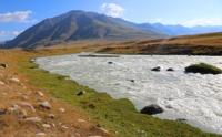
Karakol River is left tributary of Naryn.
Rest on river Naryn.
“The best place for a settlement would be at the grave of Saryk, opposite the source of the western peak of Char-Karytma; arable places are close here, down the river; and hayfields - up. On the 20th I stopped at Naryn almost opposite the Char-Karytma gorge itself (Kyzyl-su near Osten-Saken) (Sertum tianschanicum, p. 24); its valley here, except for the irrigated fields, is dry and barren, a little more food for detachment cattle was found on the island between the main channel of the Naryn and the oxbow lake, partly dried up. Immediately closer to the main channel and a wood of sea buckthorn, willow, willow and low crooked speck; the trees still retained almost all of their leaves, already strongly yellowed on the sedge, on the sea buckthorn they were still grayish-green, as in summer; mature sea-buckthorn berries attracted many small birds (Produced in Chon-burundy)."
N. Severtsov. "Journey through the Turkestan region and the study of the mountainous country of the Tien Shan." 1873
Tributaries of Naryn in Kyrgyzstan.
Karakol river basin is located on the northern slopes of the Borkoldoy ridge and consists of the following rivers: Jagalmai East, Chakyr-Korum West, Kara-Chukur, Dzhangdzhir, Kichi-Atjalau, At-Dzhailau, Karakolot, Kekdzhar, Achiktash, Karadzhilga.
48.1 kilometers after the sources of the Naryn, a tributary of the Karakol with a length of 26.4 kilometers flows from the left. Karakol River is formed at an altitude of 3825 meters above sea level from the confluence of the rivers: the right tributary - Jagalmai East, 26.2 kilometers long and the left tributary - Kara-Chukur, 19.8 kilometers long.
The river is full-flowing, the speed of the river is from 2 to 2.5 kilometers per hour. The mouth of the Karakol River is located in the Dzharyktash tract at an altitude of 2992.3 meters above sea level. The Karakol River flows through the Issyk-Kul and Naryn regions.
Geographic coordinates of Karakol River: N41°27'54.04" E77°18'47.62"
River Chakyr-Korum Western.
1.3 kilometers after the beginning of the Karakol River, a tributary of the Chakyr-Korum Western, 7.2 kilometers long, flows in from the right. The main source is located at an altitude of 4240.8 meters above sea level on the southern slope of the Jagalmay gorge.
A small tributary flows from the southern slope of the Chakyr-Korum pass, located at an altitude of 3882.4 meters above sea level. The pass is a watershed of the Chakyr-Korum West and Chakyr-Korum East rivers.
Geographical coordinates of river Chakyr-Korum West: N41°22'55.07" E77°28'24.36"
Kichi-Atjailau river.
8.4 kilometers after the beginning of the Karakol River, a tributary of the Kichi-Atjailau with a length of 3.8 kilometers flows from the left. The sources of the river are located on the eastern slope of the Kichi-Atjailau gorge at an altitude of 4472.9 meters above sea level.
In the upper reaches of the gorge there are neti glaciers. The mouth of the river is located at an altitude of 3197 meters above sea level.
Geographical coordinates of Kichi-Atjailau River: N41°22'06.91" E77°21'02.53"
Atjailau river.
9.2 kilometers after the beginning of the Karakol River, the Atdzhailau tributary, 8 kilometers long, flows in from the left. The sources of the river are located on the eastern slope of the Atjailau pass at an altitude of 4220 meters above sea level and on the southern slope of the Atjailau gorge at an altitude of 4531.1 meters above sea level. There are minor glaciers in the upper reaches of the gorge. The mouth of the river is located at an altitude of 3170.5 meters above sea level.
Geographical coordinates of Atjailau River: N41°22'18.10" E77°19'26.98"
Karakolot river.
12.6 kilometers after the beginning of the Karakol River, a tributary of the Karakolot with a length of 5.1 kilometers flows from the left. The sources of the river are located on the southern slope of the gorge at an altitude of 4445 meters above sea level and on the southern slope of the Karakolot pass located at an altitude of 4081 meters above sea level. The mouth of the river is located at an altitude of 3145 meters above sea level.
Geographic coordinates of Karakolot River: N41°23'37.67" E77°18'32.82"
Kekdzhar stream.
15.4 kilometers after the beginning of the Karakol River, the Kekdzhar Stream, 5 kilometers long, flows from the left. The sources of the stream originate from the snow-covered, eastern slopes of the Kekdzhar Pass, located at an altitude of 3998 meters above sea level.
The left sources of the stream are located on the southern slope of the Kekdzhar gorge at an altitude of 4175 meters above sea level. The mouth of the stream is located at an altitude of 3114 meters above sea level.
Geographic coordinates of Kekdzhar stream: N41°25'28.94" E77°18'13.28"
Achiktash river.
15.7 kilometers after the beginning of the Karakol River, the Achiktash tributary, 7.5 kilometers long, flows in from the right. At 4.6 kilometers after the sources, at an altitude of 3372 meters above sea level, the river forms in one channel.
The main source is located at an altitude of 4352 meters above sea level on the western slope of the northwestern spur of the Borkoldoy ridge. The left tributary originates at an altitude of 4551 meters above sea level. The mouth of the river is located at an altitude of 3113 meters above sea level.
Geographic coordinates of Achiktash stream: N41°25'59.49" E77°20'16.95"
East Jagalmai River.
The East Jagalmay River, 26.2 kilometers long, is one of the main tributaries of the Karakol River. The main sources of the river are located on the northern slope of the Borkoldoy ridge, where powerful glaciation is concentrated.
The main channel of the river is formed at an altitude of 3531 meters above sea level. The river valley expands in this place up to 50 meters. There are three glaciers in the upper reaches of Jagalmay East gorge - Jagalmay East, Jagalmay Central and Jagalmay West. The glaciers are located on the western slope of the Jagalmai East gorge.
East Jagalmay glacier is 8.1 kilometers long, the area of the glacier is 10.76 square kilometers, the perimeter reaches 19.94 kilometers. The upper feeding area of the glacier is located in the main ridge of the Borkoldoy ridge at an altitude of 4996 meters above sea level. The tongue of the glacier is located at an altitude of 3971 meters above sea level.
Jagalmay Central glacier is 7 kilometers long, the area of the glacier is 6.67 square kilometers, the perimeter reaches 18.27 kilometers. The upper feeding area of the glacier is located in the main ridge of the Borkoldoy ridge at an altitude of 5170 meters above sea level. The tongue of the glacier is located at an altitude of 3966 meters above sea level.
Jagalmai West glacier is 5.7 kilometers long, the area of the glacier is 8.19 square kilometers, the perimeter reaches 19.65 kilometers. The upper feeding area of the glacier is located in the main ridge of the Borkoldoy ridge at an altitude of 5015 meters above sea level. The tongue of the glacier is located at an altitude of 3834 meters above sea level. The mouth of the Jagalmai East River is located at an altitude of 3279 meters above sea level.
Geographical coordinates of East Jagalmay River: N41°20'50.32" E77°33'06.65"
Kara-Chukur river.
After 25.2 kilometers after the sources of the East Jagalmai River, a tributary of the Kara-Chukur with a length of 19.8 kilometers flows from the left. The sources of the Kara-Chukur river are located on the northern and northwestern slopes of the Borkoldoy ridge.
One of the main sources is located on the northern slope of the Kubergenty pass, located at an altitude of 3907.2 meters above sea level. In the upper reaches of the western source of the Kara-Chukur, there is the Kara-Chukur glacier with a length of 2.9 kilometers, the area of the glacier is 5.56 square kilometers, the perimeter reaches 10.65 kilometers.
The upper feeding area of the glacier is located in the main ridge, on the southern slope of the Borkoldoy ridge at an altitude of 4790 meters above sea level. The tongue of the glacier is located at an altitude of 4064 meters above sea level.
The mouth of the river is located at an altitude of 3285 meters above sea level. Kara-Chunkur receives 10 large and small tributaries on the right, including a large tributary - Karadzhilga, on the left 9 tributaries including a large tributary Dzhangdzhir.
It should be noted that the Kubergenty pass is a watershed between the basins of the Naryn and East Aksai rivers. The East Aksai River is a tributary of the Moduryum River, which in turn is a tributary of the Kokshaal River.
To the northeast of the pass is the Kogalyachap watershed plateau, which divides the sources of the Eastern Aksai and Uzengegush. The Kogalachap plateau is a bridge between the northern slopes of the Western Kokshaal-Too and the southern slopes of the Borkoldoy ridge.
Geographical coordinates of Kara-Chunkur River: N41°17'07.05" E77°24'48.25"
Karadzhilga river.
At the 11th kilometer after the sources, the tributary Karadzhilga, 12.2 kilometers long, flows into the Kara-Chkur River on the right. The origins of Karadzhilga begin with the Karadzhilga glacier, 2.5 kilometers long, located in the center of the largest glaciation of the Borkoldoy ridge.
The area of the glacier is 3.93 square kilometers, the perimeter reaches 8.17 kilometers. The upper feeding area of the glacier is located in the main ridge of the Borkoldoy ridge on the western slope of the Borkoldoy peak, 4765 meters above sea level.
The tongue of the glacier is located at an altitude of 4023 meters above sea level. The mouth of the river is located at an altitude of 3543 meters above sea level.
Geographic coordinates of Karadzhilga River: N41°17'26.78" E77°28'15.99"
Jangjir river.
At 16.6 kilometers from the beginning of the sources, the tributary Jangdzhir, 15.3 kilometers long, flows into the Kara-Chukur from the left. The sources of the river are located in the Kalyntaigak tract, on the southern slopes of the eastern part of the Naryn-Tau ridge at an altitude of 4140 meters above sea level.
On the left, the river receives 7 tributaries, on the right side, 6 tributaries. At 10 km, at an altitude of 3413.6 meters at sea level, the main channel of the river is being formed. In the upper reaches of the right unnamed tributary of the Dzhangdzhir there is a glacier 1.2 kilometers long, the area of the glacier is 0.93 square kilometers, the perimeter reaches 7.22 kilometers.
The upper feeding area of the glacier is located in the main ridge, on the northern slope of the Borkoldoy ridge at an altitude of 4636 meters above sea level. The tongue of the glacier is located at an altitude of 4070 meters above sea level. The mouth of the river is located at an altitude of 3320.8 meters above sea level.
Geographic coordinates of Jangdzhir River: N41°19'55.62" E77°21'56.59"
Authority and photos by
Alexander Petrov.