Вы здесь
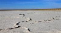
Saline land Zharsuat in Korgalzhyn reserve.

Saline land and salt marsh of Korgalzhynre Reserve.
“An ordinary tourist wants to see places where there are no tourists”
Sights of Tengiz-Korgalzhyn depression.
Zharsuat salt marsh is located at an altitude of 304 meters above sea level, located in north of Kazakh small hills, at bottom of Tengiz-Korgalzhyn depression, on territory of Korgalzhyn natural park, in Korgalyzh district in southwest of Akmola region.
The Zharsuat salt marsh is part of the Tengiz-Korgalzhyn lakes system. The area of the Zharsuat salt marsh is 11.36 square kilometers. The length of the lake's coastline reaches 13.33 kilometers. The length of the Zharsuat salt marsh is 5.1 kilometers, the greatest width in the southern part is 2.7 kilometers.
In the eastern part, along the entire length of Zharsuat, it borders with the Shubar litter, which consists of almost separate saline surfaces. The western part of the salt marsh is located from the southern part of Lake Isey at a distance of 690 meters.
Along the eastern part of the lake there is a country road that leads to the Kyzyl Mosque cordon. In 1976, the Tengiz-Kurgalzhyn system of lakes, including the Zharsuat salt marsh, was included in the list of wetlands of international importance subject to the Ramsar Convention.
The Zharsuat salt marsh is one of the typical salt marshes of the Korgalzhyn Nature Reserve. The profile is very poorly differentiated into horizons. In its upper part there is always a thin salt crust, which cracks and disintegrates when dried. Its thickness is insignificant and does not exceed 0.5 - 2 cm.
Below lies a weakly expressed, small-thick humus horizon, which gradually turns into the parent rock. When wet, the entire profile has a fairly monotonous structure.
Geographic coordinates of saline land Zharsuat: N50°26'59 E69°41'43
Authority:
Alexander Petrov.
"Reserves of Central Asia and Kazakhstan." Publishing house "Mysl". 1990 Edited by V.E. Sokolova, E.E. Syroechkovsky.
Photos by:
Alexander Petrov.


