


![]()
Вы здесь
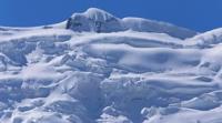
Ailanysh Central Glacier.
Djety-Oguz spur glaciers.
“I believe that mountaineering should be fun, even when it gets really tough, and even when someone has to pay for the challenge. Because if we are willing to pay that price, then mountaineering is really fun.”
Chris Bonington.
Walk to Ailanysh Central Glacier from Djety-Oguz Gorge.
Upper boundary of Ailanysh Central Glacier is located at an altitude of 4679 meters above sea level, end of glacier is at an altitude of 3194 meters above sea level, located in upper reaches of Ailanysh Gorge, on northern slope of Terskey Ala-Too Range in Djety-Oguz District of Issyk-Kul Region.
The area of the glacier is 4.26 square kilometers, the perimeter of the glacier reaches 9.42 kilometers. The length of the glacier is 4.3 kilometers. The end of the glacier is located at an altitude of 3194 meters above sea level and is under moraine deposits for 1.4 kilometers.
The glacier is the source of the Ailanysh River, which is 9 kilometers long and is a right tributary of the Jety-Oguz River. At the upper boundary of the southeastern part of the glacier in the Oguz-Bashi spur is the Boris Yeltsin Peak, 5168 meters above sea level.
The peak is the third highest in the Terskey Ala-Too ridge system after the Karakol and Dzhigit peaks.
Geographic coordinates of Ailanysh Central Glacier: N42°09'57 E78°24'38
Authority and photos by:
Alexander Petrov.