


![]()
Вы здесь
History of Khanga Baba.
Tourist routes of Mangyshlak.
"In the IInd century BC, within the boundaries of Central Asia, there was a large city of Khorezm - Khanga (Kanga). The inhabitants of this city were called Khanguys. In the Ist - IVth centuries BC, Khanga served as the western bastion of Khorezm. The main center of trade and state protection was concentrated there. In the district of Khanga (Kanga) Baba, there are many burials, which indicates a large number of people who once lived there."
Professor of Moscow State University S. Tolstov.
Tours in Mangystau.
There are several different versions about the origin of the name Khanga Baba. Some researchers associate it with the name of the Turkic-speaking tribal association "Kangly", who lived to the south and west of the Aral Sea in the Vth - XIIth centuries, and in the XIIIth century were defeated by the Mongols and scattered throughout the world.
Over time, the surviving representatives of this association mixed with the Central Asian peoples, in particular, with the Oghuz - the ancestors of the Turkmen, who once inhabited Mangyshlak. Thus, it can be assumed that the name Kanga has a very ancient origin.
Over time, this word acquired a territorial and political meaning - defining the boundaries of possessions. Trading points, fortifications, guard posts created on the borders of the Khorezm state were called Kanga. It is characteristic that in the northwestern part of Khorezm on the border with Ustyurt, there is an ancient settlement, also called Kanga Kala.
The area in question was a real oasis in those distant times and had a reliable fortress with a fortified military garrison guarding the Khiva road, which is why it was called Kanga. The ruins of the fortress confirm this version. The remains of a settlement and burial ground, located fifteen kilometers southeast of the Kanga Baba valley, on the edge of a plateau in the Tubezhik area, complement the ancient monument.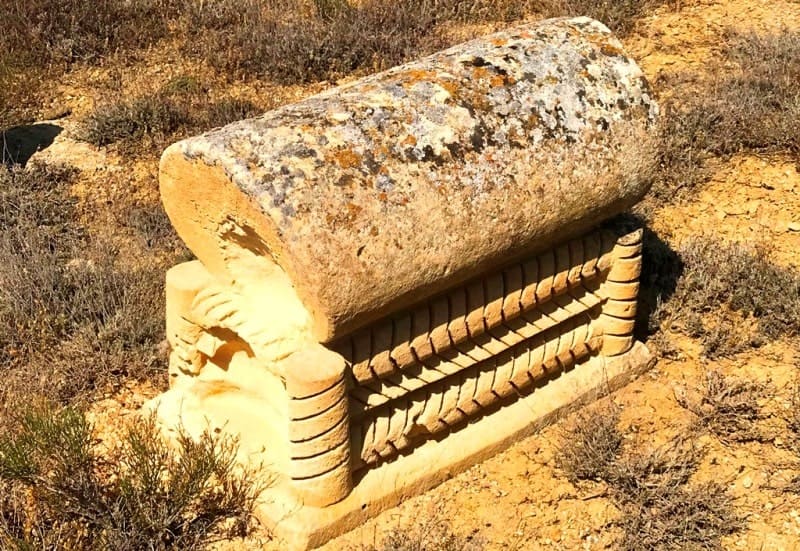
The fortress is located on a cape-shaped rocky ledge of a plateau-shaped elevation cut by the Tubezhik canyon (west of the canyon mouth), and is a stone rampart-like elevation with masonry elements, as well as sections of surviving walls across the cape and along its perimeter.
The main transverse wall, sixty-five meters long, had six semicircular towers and two passages protected by two separate towers. Over time, the ruins of the towers, whose diameter was five to six meters, and the thickness of the walls reached two meters, turned into burial mounds.
The masonry is double-row, with rubble filler. An auxiliary wall runs along the perimeter, but in areas where the steep walls of the cape pass, it is destroyed. The width of the auxiliary wall reached two meters. From the eastern and western sides of the cape, paths lead into the valley.
The western path also comes out to the area in front of the fortress. In the fortress itself and in the adjacent territory, you can find fragments of easel and molded vessels. Researchers come to the conclusion that in a later period of its existence, the fortress was used as a temporary shelter for caravans.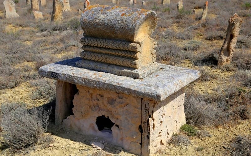
The approximate dating of the construction of the fortress is the Xth-XIIth centuries. It was built, apparently, by the Turkmen population of Mangyshlak, because in his notes "Trip to the Mangyshlak Peninsula" M. Ivanin notes: "There are many ruins of fortresses throughout the peninsula.
At the Kanga Baba valley, the fortress is built in a rock, and seems impregnable for the nomadic people, but, according to the Kyrgyz, they took it, cutting off the garrison's water. The fortress is in a badly destroyed state." The settlement that arose near the fortress was located at the base of the cape.
There are also remains of building foundations, where fragments of easel and molded vessels are also found. At the western base of the cape there is a small burial ground. The cape itself rises above the valley. Both in ancient sources and in the chronicles of many researchers of Central Asia and Kazakhstan there are numerous references to the Kanga Baba valley.
Here is what Professor S. Tolstov of Moscow State University writes about this:
- “In the IInd century BC, within the borders of Central Asia, there was a large city of Khorezm - Khanga (Kanga). The inhabitants of this city were called Khanguys. In the Ist - IVth centuries BC. Khanga served as a western bastion for Khorezm. The main center of trade and state protection was concentrated there. In the district of Khanga (Kanga) Baba there are many burials, which indicates a large number of people who once lived there".
In turn, Bronislav Zaleski, who visited here in the middle of the XIXth century as part of the Karatau expedition together with Taras Shevchenko, noted that the necropolis bears the name of a certain saint who lived in the valley. The saint was a native of the Turkmen people who lived in Mangistau before they were driven out of here by the Kazakhs of the Adai clan community.
Legends say that this saint may have been the first to plant trees in the valley or looked after the trees growing here, because in the time of B. Zaleski one could still see traces of the land that had once been cultivated. It is possible that the saint tried to introduce the beginnings of agriculture among the nomads here.
Most likely, it was he who dug wells in the surrounding ravines, of which there are quite a lot here. This good deed - the improvement of the waterless desert - was duly appreciated by his descendants, who elevated the elder to the rank of saints, and the valley became sacred.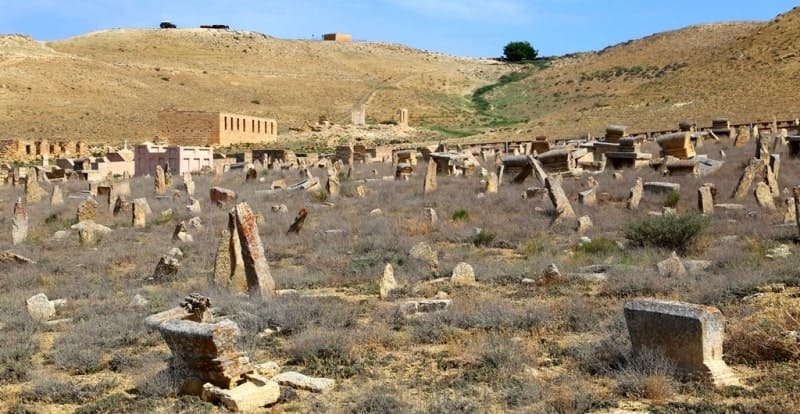
The legend also has as a red thread the idea that Kanga Baba was one of the legislators of this region and, probably, took part in the creation of an unwritten legal code of local nomads, which formed the basis of legal relations between the inhabitants of the steppe.
A little later than B. Zalessky, I. Odakhovsky, calling this area "Khan-abu", writes: "... this name comes from the Kyrgyz words: khan - to own and abu - grave, i.e. this is the place where the khan is buried." One way or another, the only thing that is known for certain is that the name was left by the Turkmen population who left Mangyshlak in the XVIIth century.
The Kanga-baba monument complex is located in a picturesque area (it was not for nothing that it was chosen as a place for permanent residence in its time) - on the southern slopes of the plateau, the gentle spurs and ravines of which gradually turn into a wide valley.

Authority:
https://vk.com/wall-45626196_428
Photos by:
Alexander Petrov.