







Вы здесь
Western Kara-Tokoy Lakes.
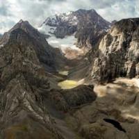
Hike to Western Kara-Tokoy Lakes.
"It's clear that night falls earlier here.
When darkness falls in the valley, sunrise is already in the mountains.
In the hours when the world has not yet awakened,
Ice is already glowing in the sun on the mountain ridges."
Alykul Osmonov. "Kyrgyz Mountains." 1946.
Highlights of high-mountain lakes of Chatkal Range.
The high-mountain, freshwater, flowing Kara-Tokoy Western lakes are located in the upper reaches of the river of the same name, on the western slope of the Chatkal Range, in the Chatkal district of the Jalal-Abad region.
The group consists of three successive bodies of water: Lower Kara-Tokoy and Western Kara-Tokoy, located at an altitude of 3,206 m. a. s. l., Middle - at an altitude of 3,302 m. a. s. l., and Upper - at an altitude of 3,329 m. a. s. l. The lakes are located in one of the most inaccessible high-mountain regions of the Chatkal Range, where odern glaciation combines with numerous traces of ancient glaciers.
The reservoirs are located approximately 2.8 km northwest of Lake Eshenkul, 2.8 km north of the Chatkalskaya Ushba summit (4,339 m. a. s. l.), 5.5 km northeast of the moraine lake Kara-Tokoy, and 6.3 km northwest of the Kara-Tokoy pass (3,620.3 m. a. s. l.).
The group of lakes represents a unique system of high-altitude glacial reservoirs, closely linked to the modern glaciation of the Chatkal Range. The sequence of natural processes is particularly clearly visible here: glacier, meltwater, moraine deposits, lakes, and a river, which, after leaving the high-altitude zone, continues its journey to the Kara-Tokoy River.
Morphometric features of Kara-Tokoy Western lakes.
The three lakes differ significantly in size and configuration. Although they are part of a single glacial-moraine system, each occupies its own basin and has a unique shape.
Lower Lake Kara-Tokoy Western.
Located at an altitude of 3,206 m. a. s. l., it has an elongated shape and is oriented from southeast to northwest. The length of the reservoir is 227 meters, with its greatest width in the southern part reaching 61 meters. The water surface area is approximately 0.01 sq. km., with a shoreline length of approximately 0.51 kilometers.
The Lower Lake is the initial point of the group's surface runoff. It is from here that the Kara-Tokoy Zapadnaya River begins, then flows through complex moraine-glacial terrain, repeatedly disappearing beneath rock masses and resurfacing.
Middle lake, Kara-Tokoy West.
Is 96 meters higher than the lower lake, at an altitude of 3,302 m. a. s. l. It is significantly larger than the lower lake. The lake extends 430 meters from south to north, and its greatest width in the central part is 242 meters. The surface area is approximately 0.06 sq. km., and the shoreline reaches 1.07 kilometers.
The middle lake is the largest of the three lakes. Its relatively wide basin indicates a more complex structure of the glacial basin and the nature of the moraine dams. Here, the influence of ancient glaciation, which shaped the modern topography of the upper Kara-Tokoy, is particularly evident.
Upper lake, Kara-Tokoy West.
Is located even higher, at an altitude of 3,329 m. a. s. l. It extends from the southeast to the northwest. Its length is 377 meters, with a maximum width of 182 meters in the southern part. Its water surface area is approximately 0.04 sq. km., and its shoreline is approximately 0.96 kilometers long.
Thus, the three lakes form a unique altitudinal sequence: from the Lower Lake, located at an elevation of 3,206 meters, to the Upper Lake, at an altitude of 3,329 meters. The difference in elevation between the outermost lakes is 123 meters. The ratio of their areas is also interesting.
The Middle Lake, despite its intermediate location, has the largest water surface area – approximately 0.06 square kilometers. The Lower Lake is significantly smaller – approximately 0.01 square kilometers, while the Upper Lake is approximately 0.04 sq. km.
This once again demonstrates that the size of high-mountain moraine lakes depends not only on their location within a single river system, but also on the individual structure of the glacial basins and the moraine ridges that dam them. Together, the three bodies of water form a compact system of high-mountain lakes located between the modern Kara-Tokoy West Glacier and the Kara-Tokoy River valley.
Their sequential arrangement allows us to trace how glacial and moraine processes shaped the complex system of water accumulation and movement in the upper reaches of the Kara-Tokoy.
Morainic origin of Kara-Tokoy West lakes.
The Kara-Tokoy West lakes are high-mountain moraine lakes. Their basins were formed under the influence of ancient and modern glaciation. As the glacier moved, eroded rocks were carried down the valley, and after the glacier retreated, they remained as ridges and accumulations of moraine material.
Such deposits can create natural dams, behind which meltwater and atmospheric water accumulate. Therefore, chains of lakes often form in high-altitude regions, connected by surface streams or watercourses hidden under moraine. Particularly characteristic in this regard is the system of the Middle and Upper Kara-Tokoy Western Lakes.
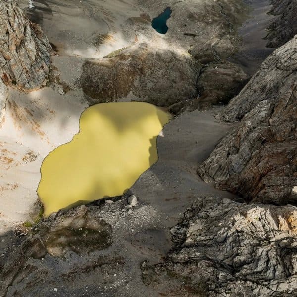
Their basins are of moraine-dammed origin and are associated with the activity of ancient and modern glaciations. The unusual appearance of the lakes, as well as the peculiarities of their lighting, have given rise to another name for this group of lakes: "golden lakes."
This definition is attributed to the unusual shades of the water, which arise from the reflection of sunlight off the surface of the lakes and the surrounding rocky slopes. In the highlands, water color can indeed vary significantly depending on lighting, atmospheric conditions, and the amount of suspended mineral particles of glacial origin.
Kara-Tokoy Western River.
From the Lower Kara-Tokoy Western Lake flows the Kara-Tokoy Western River, which is approximately 8.4 kilometers long. Its source is in the glacier of the same name on the western slope of the Chatkal Range. This river's unique feature lies in the unusual nature of its channel.
After approximately 640 meters from its source, the stream disappears among thick moraine deposits and continues along underground channels and voids formed within the moraine massif. The water then resurfaces and passes through three moraine lakes located further down the valley.
Thus, the river flow here is not a continuous surface river: it periodically disappears beneath the rock mass and reappears on the surface. An even more unusual section is located approximately 6.8 kilometers from its source. Here, the channel again runs into a large moraine massif, which almost completely blocks the gorge.
The water is forced to find alternate routes, and throughout Approximately 1.5 kilometers of the lake flows through underground channels within moraine deposits. Such phenomena are especially characteristic of areas of ancient glaciation. The moraine here serves both as a natural dam and a complex system of underground channels through which water can move between different levels of the valley.
In the lower part of its course, the Kara-Tokoy Zapadnaya River emerges from the highland zone and flows into the Kara-Tokoy River. The mouth is located at an altitude of approximately 2,643 m. a. s. l. The river is a left tributary of the Kara-Tokoy and, through it, belongs to the Chatkal River basin.
Kara-Tokoy Zapadny Glacial Bowl.
The lakes are located in a vast high-mountain cirque - a bowl-shaped basin formed by an ancient glacier. The lakes are adjoined to the south by the Kara-Tokoy Zapadny Glacier of the same name. The glacier is located in a narrow rock trough on the western slope of the Chatkal Range and is a vital source of water for the entire natural system.
Its location directly above the lakes creates a landscape characteristic of high mountains, in which glacial masses, moraine ridges, and reservoirs form a single complex. The glacier extends approximately 1.7 kilometers. It extends primarily in a latitudinal direction along the main ridge of the Chatkal Range.
According to available data, the length of the glacier massif in this direction reaches approximately 1.3 kilometers, the area is approximately 1.8 square kilometers, and the perimeter is approximately 5.09 kilometers. The upper feeding area of the glacier is associated with the Chatkal Ushba peak, 4,339 m. a. s. l.
Thus, there is a significant elevation difference between the upper part of the glacier system and the lakes, determining the direction of meltwater movement. The morphological features of Kara-Tokoy West combine those of a cirque and a hanging glacier.
A distinct glacial tongue is absent. The lower part of the glacier surface is often covered with debris brought down from the slopes and formed by the disintegration of rock. The glacier is fed primarily by the accumulation of snow, firn, and solid atmospheric precipitation.
Transverse cracks are observed in the lower part of the glacier massif, indicating the movement of ice along an uneven and dissected bed.
Geographical coordinates of Kara-Tokoy West Glacier: N41°58'13 E71°47'59
The glacier, lakes, and the Kara-Tokoy West River form a single natural system. Kara-Tokoy West is of particular interest not so much as three separate lakes, but as a single natural complex. The glacier is located at the top of the system. Its melting creates runoff that flows into the high-mountain basin.
Moraine ridges regulate water movement and create natural dams. As a result, a chain of lakes forms, and below, the water collects into the Kara-Tokoy West River. But the water's movement doesn't end there. The river periodically disappears beneath the moraine, resurfaces, passes through further bodies of water, and then returns to underground channels.
This creates a unique natural system in which water constantly transitions from one relief state to another: ice - stream - lake - underground stream - river - underground stream again. This is precisely what makes the upper reaches of the Kara-Tokoy particularly interesting to study.
Geographers will be interested in the structure of the glacial relief, glaciologists in the current state of the glacier, hydrologists in the unusual regime of surface and underground runoff, and travelers in particular will be able to see a virtually untouched stretch of the Western Tien Shan highlands.
High-mountain landscape of Kara-Tokoy West.
The lakes are located well above the tree line. The region is dominated by a harsh, high-mountain terrain shaped by ancient glaciation, frost weathering, and modern slope processes. The shores of the reservoirs are surrounded by rocky slopes, moraine ridges, and scree.
In these conditions, vegetation is sparse and adapted to the short summer period. Against the backdrop of gray-brown cliffs, the glacial surfaces, snowfields, and blue or greenish-golden waters of the lakes are particularly striking. In clear weather, the surrounding peaks are reflected in the surface of the reservoirs, and in low cloud cover, the lakes practically merge with the rocky surroundings.
Tourist value of Kara-Tokoy West landscape.
The Kara-Tokoy Western Lakes are located in an area of interest primarily to experienced travelers, explorers, and lovers of little-studied high-altitude terrain. There are no roads leading to the lakes. The approach is through challenging mountain terrain, requiring consideration of scree slopes, moraines, glacial features, and sudden weather changes.
Particular caution should be exercised near glaciers and in areas where the riverbed disappears beneath moraine deposits. The moraine surface can conceal voids and underground streams, so navigating these areas requires considerable experience.
The best time to travel is during the short summer period, but even in summer, the high-altitude weather can change very quickly. Temperatures drop significantly at night, and snowfall is possible even during the warmer months. These lakes are among those rare places in the Chatkal Range where natural processes can be observed almost directly: the glacier continues to feed the river, the moraines continue to determine the direction of runoff, and the water creates and modifies high-altitude lakes.
Geographical coordinates of Lower Lake Kara-Tokoy West: N41°59'42 E71°47'01
Geographical coordinates of Middle Lake Kara-Tokoy West: N41°59'23 E71°47'23
Geographical coordinates of Upper Lake Kara-Tokoy West: N41°59'08 E71°47'31


Authority:
Alexander Petrov.
Photos by:
Aleлeksey Ognev. Bishkek.