







Вы здесь
Kuyuk-Kesken-kala. S. P. Tolstov.
Visit to Kuyuk-Kesken-kala settlement.
"The Ghuzz cities are numerous, stretching one after another to the north and east. They have inaccessible mountains, and they have fortified fortresses there, in which their princes take refuge and in which they store their food supplies." There are people (appointed princes) who guard this land... the main city of their (Guz tribe Hand aga) is called Khiam. There they find refuge and there they hide with their belongings... it is an impregnable fortress on the top of a mountain with a difficult climb and it is extremely impregnable and fortified... The city of Khiam is to the north of the river Djadjam to the south of the river, both of them are small cities, highly fortified and both are the same... On the bank of this river (Magra or Marga) there is a mountain with a high peak, from it flow more than a thousand springs, which all flow into the river Magra. At the top of it are two cities in the form of fortresses, the name of one of them is Nudjah, the other Badagah, between them a day's journey... At the foot of the mentioned mountains lie two cities, the name of one of them is Daranda, the other is Darku. Daranda is to the west of Darku, between them the distance is 3 days (of journey). These are 2 small cities, in them there are markets, crafts and excellent goods, both They are extremely fortified and impregnable. They have constant snow, and the inhabitants of these countries harvest their crops unripe and dry them in smoke and under a canopy; this is due to their severe cold, constant rain, and the rarity of dry days..."
Al-Idrisi. Al-Idrisi's main scholarly work, "Nuzhat al-mushtaq fi ikhtirak al-afak," "The Book of Roger." 1154.
"The Ghuzz do not have a single city, but the people who have felt yurts are very numerous."
Anonymous Tumansky. "Hudud al-alam." Xth century.
Ghuzz ancient settlements.
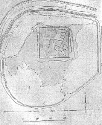
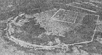
The largest of the explored settlements, located on the southern bank of a now dry, densely overgrown with shrubs, channel of the ancient delta. This vast settlement, irregularly rounded in outline, measures 560 x 700 m, stretching from east to west.
The area of the settlement, surrounded by a heavily eroded rampart that slightly protrudes above the surface of the inner part of the settlement, is the result of the erosion of mudbrick walls. It rises above the surrounding terrain to a height of about 2 m.
In the northeastern corner is a square mound measuring 210x210 m, rising 3 m above the general level of the settlement (5 m above the surrounding terrain). The citadel is completely built up with rooms, clearly visible in plan. The walls of the rooms are made of square mudbricks of quite variable sizes from 28x28 to 40x40 cm, the predominant size being 33x33 and 35x35 cm (i.e., close to the Khorezmian standard of the Afrighid period).
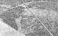
The same brick sizes are traced in the embanked walls and in many Numerous buildings on the site of the settlement itself, the layout of which, although clearly visible in places, is generally poorly traced. The square citadel has an extremely unique layout, striking in its irregularity.
A corridor about 1.5 meters wide runs around the periphery of the square. The square is divided internally by a street about 3 meters wide, running diagonally (closer to the eastern edge). Crooked alleys branch off from it in various directions and at various angles, dividing the entire area of the citadel.
Rooms of irregular shape and varying sizes, preserved only in the building plan, are in turn divided into squares by walls usually two bricks thick (flattened); their size varies between 4x4 and 23x23 meters. An ash cultural layer exposed inside the rooms of both the settlement and the citadel is abundant with a variety of ceramics, fragments of copper objects, and poorly preserved animal bones - primarily small horned cattle.
Livestock, but the bones and skulls of horses and camels are also found. The exceptional abundance of animal bones sharply distinguishes these settlements from both the ancient and medieval settlements of Khorezm.
Geographical coordinates of Kesken Kuyuk-Kala settlement: N45°31'00 E61°27'27
Literature.
P. Lerch. "Archaeological Journey to the Turkestan Region in 1867," St. Petersburg, 1870.
17 On the localization of early medieval Yangikent, see, in addition to the central works of P. Lerkha, Barthold, Turkestan, II, pp. 179-180; ditto, History of Irrigation of Turkestan, pp. 149-150, etc.; MITT, I, 150, note 9. t
18 V. Kallaur, Ancient Cities and Villages in the Perovsky District, in the Valley of the Syr Darya and Yana Darya Rivers, PTCL X, appendix to protocol 17/X1I 1903, no. 2.
19 E. Smirnov, Antiquities on the Middle and Lower Reaches of the Syr Darya River, PTCL, appendix to protocol November 17, 1897, pp. 1-14.
20 For a brief report on the work of the Khorezm expedition of 1946, see IOIF, 1947, No. 2; see also the map of monuments there.
21 For a justification for the location of this city, see our article, planned for publication in VDI. 12 We are publishing a preliminary description of the Jety-Asar complex in SA, XL.
Authority and photo by:
S. P. Tolstov. "Cities of the Guzy People." Historical and Ethnographic Sketches. Soviet Ethnography. Publishing House of the USSR Academy of Sciences. No. 3, 1947.