Вы здесь
Kesken Kuyk-Kala Settlement.


Ancient sites of ancient settlement Kyzylorda of area.
“The distance of time’s separation brings us remnants of memories so ancient that most are lost in the mists of illusion…”
A.J. Vosse.
Visit to Kyzylorda of region.
Kesken-Kuyuk Kala is, together with the former winter capital of the Oguz named Yangikent, one of the former so-called “swamp cities” located in an ancient, now dry delta of river Syr Darya, the Jaxartes of ancient Greek authors. It is located in the eastern Aral region, north-western Kazakhstan. Its present name means “part” (kesken) “burnt” (kuyuk) fortified city (kala). It is probably identical with the city of Juvara mentioned by Al-Idrisi in the XII century.
The region was surveyed by the Soviet archaeologist S.P. Tolstov (1907 - 1976) in the early 1950s who dated the foundation of these cities to the early centuries of our era; they belonged to the area of the local Dzetyasar culture (early III rd -late VI centuries A.D.). There are indications that the foundations occurred on the sites of earlier Bronze Age settlements.
Based on numismatic finds in Kesken Kala and other neighbouring “swamp cities”, it is believed that the region had latest by the VII century A.D. close economic relations with Afrigid Khoresm (IV – X century A.D.) In those times, one of the numerous branches of the transcontinental trade routes labelled “Silk Roads” passed through this region.
This branch via the north of the Caspian Sea came into existence as a result of a political and economic approach between Byzantium and the Western Turkic Qaghanate to bypass the common adversary Sassanid Iran.
In the X – XI centuries these cities belonged to the loose federation of Oghuz and represented one of the urban components of the combined stock-raising, agricultural and aquacultural Oghuz economy. The “swamp cities” in the Syr Darya-Delta blossomed till the XIIII century A.D., the time of Mongol conquest. In the case of Yangikent, the city was rebuilt after its partial destruction by the Mongols at another place nearby; it then belonged to the Ulus of Jochi and was located at a caravan road junction.
The ancient site of Kesken-Kuyuk Kala is the largest of the ‘swamp sites' and is located on the Southern bank of the presently dry, thickly grown with bushes ancient delta of Syr Darya. Following the curve of external walls, the site of the ancient town had taken on a form of irregular round outline. The size of the total area, measured by the cardinal points, is c. 530.000 sq.m.
The site is structurally divided into three main parts – the central part, which S.P.Tolstov called ‘citadel' and two vast sections surrounded by a ring of irregular shaped walls. A wall, extended in the north-south line on the eastern side, divides the territories of these two sections, Rabad 1 and Rabad 2. The first one is located toward the south, south-east and east from the central section and is named Rabad 1, its size is c. 317.000 sq.m.
Rabad 2 occupies the territory located toward the east, north-east and north from the central hillock. It measures c. 150.000 sq.m. Northern part of Rabad 2 is water-worn with creek waters, and the wall in this part extended along the west-east line; it is partly preserved and the outlines of towers are clearly marked, as they are visible on the surface in a form of hillocks, 7 - 9m in diameter and 1 - 1,5m high; the distance between the towers is 20 - 25meters.
The Central hillock is surrounded by walls which gives it a square outline which overlooks the surrounding country by 5 - 10 meters; it measures c. 48.300 sq.m. In turn, it is divided into two parts: the citadel itself (3.600 sq.m.), located in the south-west quarter of the central hillock, and the shakhristan (44.700 sq.m.), which belts the citadel from northern and eastern sides.
The planning of citadel and shakhristan is compact. The citadel of the ancient city is entirely built-up with well-traceable irregular design. Based on aero-photo materials, one can see the division of the central part of the city into 10 sections, one of which in the south-west, was occupied by the citadel. These sections are formed by streets and alleys, which makes them different in area and shape. In average, the area covered by one section is 3-4 thousand square meters.
The central street actually crosses the center of the site dividing it into two parts. The width of the street is 5 - 5,5m. It seems that after a partial destruction of the city by the Mongol invasion, there were pottery kilns arranged in some places along the walls, which is evident from distinctive holes, concentration of ceramic ash and fragments of green-enamel pottery fragments.
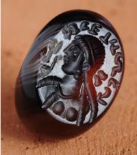
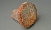
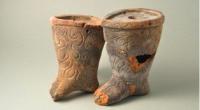
On the ground, several objects were found such as pottery shards, bones, numerous metal objects, coins and a gem. Most coins stem from a Khorezmian mint, dating from the VIII to IX centuries A.D.; other coins from the Turgesh Qaghanate (699 - 766 A.D.), from the Bukhar-Khudat (rulers of Bukhara, V - VIII centuries), from the Chinese Tang (618 - 907) and the Kharakanid (IX - XIII centuries).
The ancient site of Kesken-Kuyuk Kala is the largest of the ‘swamp sites’ and is located on the Southern bank of presently dry, thickly grown with bushes ancient delta of the Syr Darya. Following the curve of external walls, the site of the ancient town had taken on a form of irregular round outline. The size of the site following the north-south line is 840m; along the west-east line 820m; total area is over 530 thousand square meters.
The site is structurally divided into three main parts – central part, which S.P.Tolstov calls ‘citadel’ and two vast sections surrounded by a ring of irregular shaped walls. (1) The central hillock, 230m (to the north-south) x 210m (to the west-east), is surrounded by walls which gives it a square outline and which overlooks the surrounding country by 5 - 10 meters.
It can be divided into two parts: the citadel itself, located in the south-west quarter of the central hillock, and the shakhristan, which belts the citadel northern and eastern sides. - In 12 - 13 centuries, after partial destruction of the city, there were pottery kilns arranged in some places on the walls, which is evident from distinctive holes, concentration of ceramic ash and fragments of green-enamel pottery from fragments.
According to the data of the Choresm archaeological expedition, the dating of the swamp sites is defined by a chronological period from the middle of the 1st millennium B.C. and the establishment of settlements on the sites of the future cities, the forerunners of which, in turn, were settlements of the Bronze Age, to the period of developed Middle Ages in the XI - XII centuries A.D.
According to data collected in 2008 on the basis of relative dating of ceramic materials, the upper dispel level can be dated to the end of the XII beginning of the XIIIcentury; and the period of destruction occurred in the XIII century. There is a burial mound of Early Iron Age located two kilometres to the south-east from Kesken-Kuyuk kala. During 2009, exploratory excavations within the northern group of mounds was conducted.
An entire plan of all burial mounds has not yet been done and the survey focussed at the northern chain only. Thus, explorations concentrated on the mound called “western” mound as it is westernmost large mound of the northern chain that consists of 4 mounds on a sepulchral field that is notable for its size. Diameter of the mound is 40m, its height is up to 1.5m. The mound is divided into two halves by a balk that is 1m wide. Balk orientation is approximately N-S.
The mound is 40m in diameter. There is an under-bush of sagebrush vegetation of pale-green colour all around it. The “ring” of this vegetation is up to 6-7 meters wide. It is especially well-defined from the south, south-east and south-west. The top of the mound is flattened; there is an insignificant dish discernible in the centre, its diameter is 6 - 7m and depth is 0,1m. On northern part the mound is divided by a road.
There was a loop-shaped pot handle discovered at the depth of 20cm from the surface level, defined as KS 1-6. Later, when clearing the vertical slice, it was noted that it belongs to the first layer that follows the vegetable layer. It differs from the top “0” loose dark brown soil by its density, light-grey tincture and numerous carbonate mottling. The layer surface is sinuous. Approximately at this mark there were few fragments of pottery KS1 -2 and iron pieces as well as bones (from the sheep?).
When digging in to the level of Layer 2, which is approximately to 0.3m deep, in three different places fragments of a juvenile’s skull (KS 1-3), jaw (KS 1-4) and clavicular bone (KS 1-5) were found. Close to the centre of the mound there also were bands of reed dust encountered. In the central part of the mound after clearing the western axial section of the balk, layers and outlines of oval pit were identified which clearly speak of the presence of a funnel, probably a burglar’s bell-pit. 70cm deeper, following the verge of the burglar’s bell-pit, a horizontal reed dust bedding appeared and at the bottom fragments of bones and of ferrous objects completely rusted through.
It became obvious that burglars had vertically gone down through the mound and accessed the burial chamber. On the southern side there is loam, sand clay filling in the upper part marked with a 2-3cm reed dust stratum. In the lower part a horizontal surface of raw brick filling which most likely was the floor of the burial chamber that had not been destroyed in this part by the burglar’s bell-pit became clearly discernible.
The filling is divided into two layers: first dark-grey clay loam and second dark brown sand clay – possibly daubing, 1-3cm thick. This layer was probably covering the entire surface of the burial chamber floor. Reed mats had been laid over it, and traces of their dust are discernable all over the surface of the surviving floor of the chamber. There are skeleton parts all over at various levels. There are no artefacts or accompanying materials found on the floor of the burial chamber.
When removing western part of the mound several fragments of pottery (field number KS 1-9) were found. After clearing of the under-mound space, some peculiarities of its arrangements were identified. Thus, three so-called “rings” have been recorded: The first ring surrounds the burial chamber; the shape of which is at the moment impossible to identify, it is of greenish-brown sand clay with numerous grayish loamy lumps of light gray colour. In western section the ring is 3 cm high and 90 to 120 cm wide.
There are small fragments of shale rock (a stone of yellowish colour that cleaves into flat plates) encountered in soil filling of the first ring. The second ring is a sand clay lumpy solidification of brownish tincture with similar above-mentioned lumps of grey colour. This ring is 50cm high and 3.5 to 3.7m wide with fragments of pottery encountered in the filling. The third ring is adjoining the second one on the outside, a solid light-gray clay loam, possibly, pahsa, 2-3cm wide and 0.4 to 0.5m high.
In the south-western sector there is a burial pit of oval shape of c. 4.40 x 1 .70. In its north-western part the burial has also been destroyed by burglar’s manhole. At the depth of 58cm, 30cm away from the south-western border of the tomb, a fragment of iron object was found (dimensions 2x1cm) and an accumulation of small pieces of wood. At the same level, a gold foil was found of light-yellow colour, rectangular, composed of several parts and pressed under the weight of soil.
The dimensions of the golden foil are 1.9 x 0.8 x 0.1cm. The foil was an ornament of the costume of the deceased and was dropped by the burglars during the grave robbery.
Geographic coordinates of the Kesken Kuyuk-kala settlement: N45 ° 31'00.60 "E61 ° 27'27.37"
Authority:
Prof. K. Baipakov, Dr. Dmitry Voyakin.


