


![]()
Вы здесь
Katu-Tau mountains.


Tourist sights of Almaty area.
"It goes without saying that we spent the entire afternoon and spent the night in Tezek's luxurious yurt. On September 7, we left Tezek's aul no earlier than 8:00 a.m. and headed southwest of his camp and toward the Katu Mountains, quite close from there. After crossing the Kok-Terek River, we crossed the entire fertile Konur-Uzen oasis and turned sharply into the Katu Mountains, whose northern slopes consisted exclusively of porphyry."
P. P. Semenov-Tyan-Shansky. "Journey to Tien-Shan." 1856-1857.
Kazakhstan Travel Explore.
The Katu-Tau (Katu) Mountains (Russian: Hard Mountains) are located south of the Altyn-Emel Range. Their southernmost extremity is 11 kilometers from the right bank of the Ili River. The southeastern part of the mountains borders the Aktau Mountains.
A small, southwestern part of the mountains is located in the Kerbulak District, while the central and northeastern parts are in the Panfilov District in the southeastern Zhetysu Region.
Physical and Geographical Characteristics of Katu-Tau Mountains.
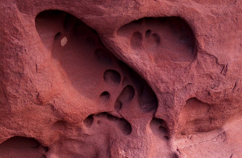
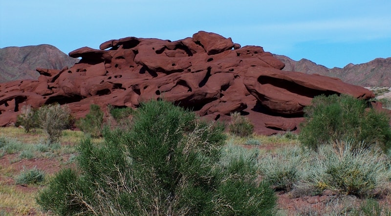
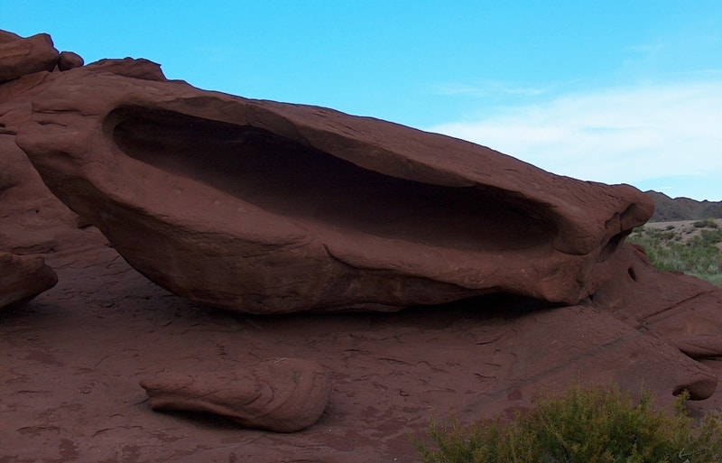
The Katu-Tau Mountains are a low, but highly dissected, volcanic mountain range. Unlike the softer sedimentary Aktau Mountains, the Katu-Tau Mountains are composed of ancient igneous rocks—lavas, tuffs, and volcanic breccias. Their formation is associated with ancient tectonic and volcanic processes that occurred in this region millions of years ago.
The mountains stretch from southwest to northeast for 45 kilometers, with their greatest width in the central part reaching 14 kilometers. The eastern boundary of the mountains is the Konyrolen River. To the south, the mountain range borders the small Katu spur and the Kumkal sands.
To the east, the mountains border the Karasalpy spur. The central part is dominated by an unnamed mountain at 1,613 meters above sea level. In the southern part of the mountains is Mount Dastar at 1,394 meters above sea level. These are dry, waterless mountains, with only three or four artesian wells in the entire mountain range.
Rock paintings in Katu-Tau Mountains.
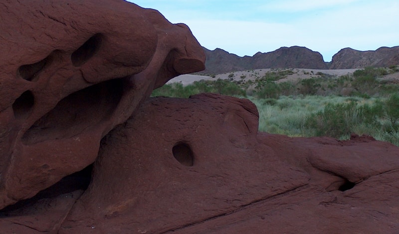
In a small branch off the main gorge are rock carvings: a goat, a deer, and a hunter pursuing mountain goats with a dog. It appears that one of the goat's legs was caught in a trap. There is also a strange argali sheep with a very long tail. At the very foot of the cliff, an image of a goat is carved into a large stone.
The round body, full belly, shaggy legs, and delicate horns clearly indicate a domestic animal in the drawing – a goat, the preserve of nomadic herders.
A cave in Katu-Tau Mountains.
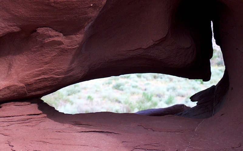
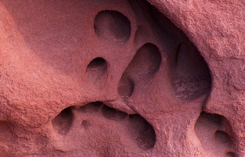
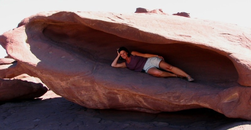
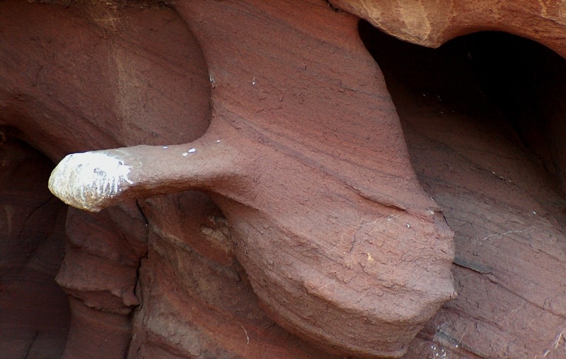
One of the few caves in the mountains is located. At the entrance to the cave is a mound of fine reddish rubble. The walls of the cave, illuminated by dim light, are of a regular rectangular cross-section; one can walk freely within them without bending.
The cave is undoubtedly man-made. The walls are carved with an undulating surface, forming small, slightly protruding columns of equal width. This characteristic is apparently due to the rock-cutting technique. The cave floor is earth mixed with rubble, and the ceiling is completely black from the soot of ancient fires.
The direction of the cave is strictly west to east. The cave is about 20 meters long, with a half-meter-deep pit at the end of the floor. At the end of the cave is a room just over two meters high. Cracks in the walls are filled with tiny gypsum crystals.
A thin layer of these crystals also covers all the walls and ceiling. In places, brown clay plaster is visible on the walls of the room; it is very hard, almost petrified. A circular channel, 3-4 centimeters in diameter and about 50 centimeters deep, has been drilled into the far wall.
A groove has been carved into the floor of the room. Beginning as a small depression near the end wall of the room, the groove descends and flows into a hole in the floor. Near the cave are the ruins of a very old building; all that remains are dilapidated walls made of stone and clay.
About a hundred meters from the cave, on a steep mountainside, in a seemingly inconspicuous place, lies a cave. A solitary burial mound.
Paleovolcanoes in the Kattu-Tau Mountains.
Two paleovolcanoes are located in the eastern and western parts of the mountains. They are believed to have classic feeder vents filled with chaotic block-bomb tuffs of andesitic composition. The structure of the volcanoes is emphasized by the presence of radial dike clusters formed during the subsidence of the volcanic cone.
The dike clusters span up to 8 kilometers. However, the most common form of feeder magma conduits in these mountains were extended fissures, along with large lava domes. The eruptions of the volcanic mass were powerful - heavy avalanches and scorching clouds laden with rock debris covered large areas.
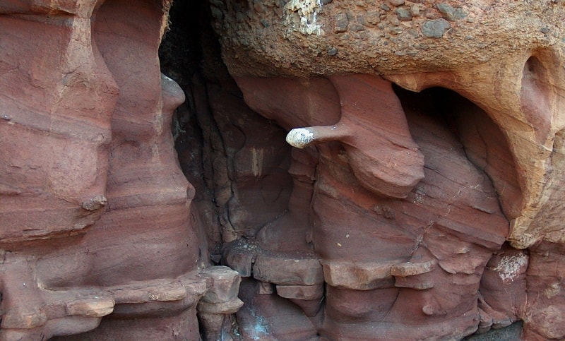
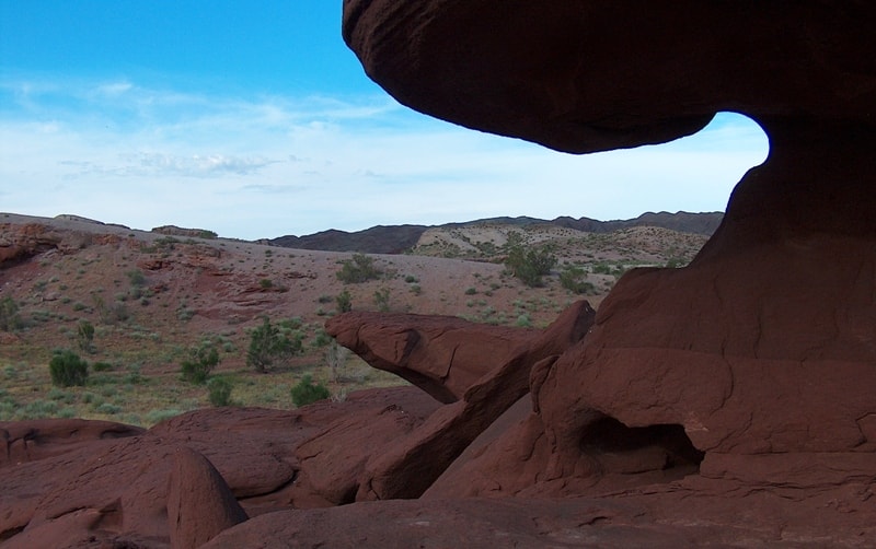
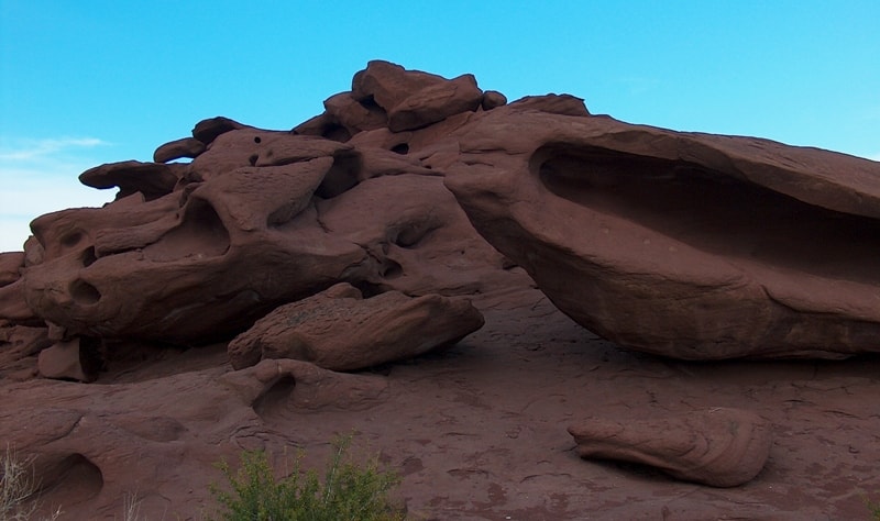
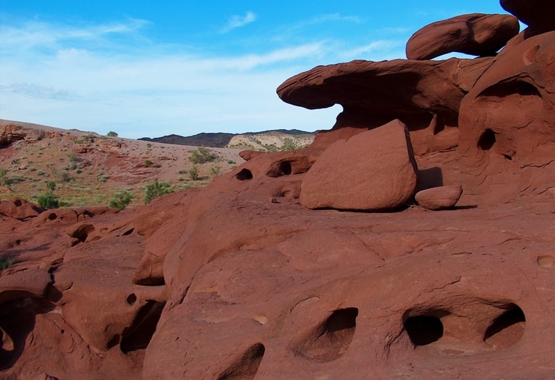
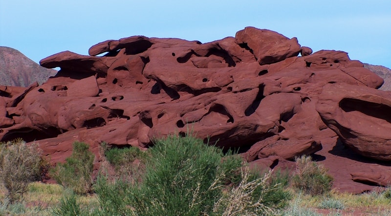
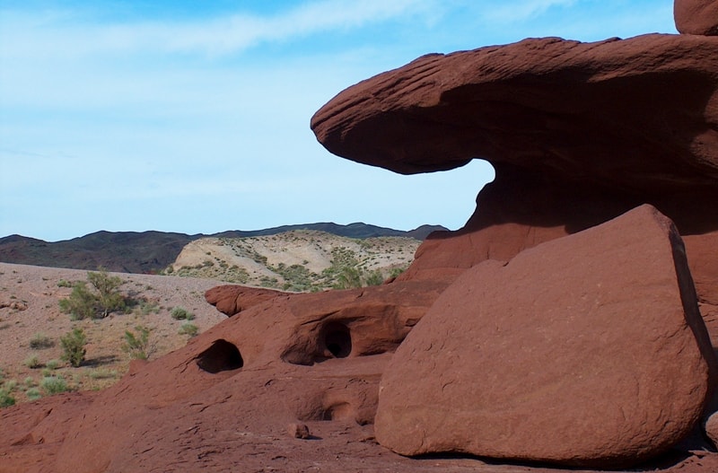
Bomb-ash and lava flows and blankets alternate with each other and have varying thicknesses, sometimes reaching 100 meters. Eruptions were followed by periods of calm, during which the volcanic material was eroded. The road follows the bed of a stream that forms here during heavy rains and ends at red cliffs so picturesque that it's impossible to take your eyes off them.
The red cliffs are small, approximately 60 meters long and 20 meters wide.
Geological features of Katu-Tau Mountains.
Traces of ancient volcanism;
The Ashchibastau Valley of Petrified Geysers;
Ancient adits; classic cuesta relief in the form of elongated ridges with asymmetrical slopes, both gentle and steep.
Katu-Tau Mountains, dating from the Permian period, are composed of lavas, tuffs, rhyolites, andesites, dacites, diabases, and basalts. In places, they are intruded by Permian and Triassic intrusions of granite, diorite, and gabbro. Devonian volcanic formations and Carboniferous sedimentary deposits are common in the eastern part of the mountains.
The cliffs are sculpted by deep weathering, creating beautiful landforms in the stone. Not far from the entrance, in the most picturesque gorge, 6 kilometers from the southern border of the mountains, to the left of a dry stream bed, are the first red cliffs, captivating with their unusual weathering patterns.
The rocky, deep gorges and canyons, completely waterless, give the impression of gloomy mountains. Rare saxaul thickets stretch along the dry gorge beds, cutting deep into the rocky desert. The Katu-Tau Mountains are very picturesque and boast archaeological and natural attractions.
Katu-Tau Mountains are "harsh mountains" of Altyn-Emel.
Katu-Tau is one of the most unusual and little-studied natural features of the Altyn-Emel National Park in the Zhetysu region. Their name translates from Kazakh as "harsh mountains," which accurately reflects the character of this landscape - wild, rugged, and yet uniquely captivating.
Katu-Tau Mountains' relief.
The region is characterized by its ruggedness: numerous gorges, couloirs, and rocky ridges create a complex orographic structure. The mountain slopes are steep, in places precipitous, with dark rock outcrops that give the massif a gloomy hue. The altitudes here are relatively low (averaging 1,500-1,700 m above sea level), but the mountains appear more massive due to the contrast with the surrounding flat and desert terrain.
Climate of Katu-Tau Mountains.
The climate of the region is sharply continental and arid. Precipitation is low, summers are hot, and winters are cold and windy. In such conditions, physical weathering processes actively develop: rocks crack, forming bizarre shapes - stone towers, grottoes, and sharp ridges.
Hydrology of Katu-Tau Mountains.
The hydrographic network is poorly developed: there are virtually no permanent streams, only temporary streams appearing after rains. Therefore, any water sources found in the surrounding area are of particular value.
Landscapes and Nature of Katu-Tau Mountains.
The vegetation of Katu-Tau is sparse and typically desert-steppe. Wormwood, saltwort, and sparse shrubs adapted to the lack of moisture are found here. However, in gorges and shaded areas, denser vegetation - grasses and shrubs - can be seen, and in spring, a brief but vibrant bloom of ephemerals.
Fauna of Katu-Tau Mountains.
The fauna is represented by inhabitants of desert and mountainous regions: argali, roe deer, foxes, various species of rodents, and birds are found here. Due to its remoteness and lack of development, the area retains its natural pristine nature.
Legends and Tales of Katu-Tau Mountains.
Several local legends are associated with Katu-Tau. One of them explains the very name of the mountains. According to legend, these places were once inhabited by stern spirits who guarded the passage through the valley. Travelers said the mountains were "angry" at intruders: sudden winds, rockfalls, and strange sounds in the gorges were perceived as manifestations of their wrath.
Another legend tells of the mountains being a testing ground for warriors. Young men had to pass through the narrow gorges of Katu-Tau to prove their strength and endurance. Those who returned were considered worthy of becoming the protector of their clan.
Tourist attraction of Katu-Tau mountains.
Bizarre landscapes formed by red sandstones; fragments of a paleovolcano. Today, Katutau attracts primarily lovers of wildlife, geology, and photography. Unlike more famous park sites such as the Singing Dune or the Aktau Mountains, there are significantly fewer tourists here, creating a sense of seclusion and pristine wilderness.
Travel in Katu-Tau Mountains.
A trip to Katu-Tau offers opportunity to:
See rare volcanic landforms;
Explore canyons and gorges;
Enjoy the silence and vastness of the steppe landscapes;
Take unique photographs of unusual rock structures.
However, a visit requires preparation. Due to the lack of water and infrastructure, it is necessary to plan your route in advance, stock up on water, and consider weather conditions. It is recommended to travel with a guide or as part of an organized group.
Hiking routes in Katu-Tau Mountains.
Visiting red-colored weathered sandstones.
Routes for experts in Katu-Tau Mountains.
Permian volcanoes Konyrulen and Katu-Tau.
Ashybastau Valley of Petrified Geysers
Visitors to the natural geopark will thus, over the course of just a few days, be able to see traces of geological processes that occurred in southern Kazakhstan over 600 million years, from the Paleozoic to the present day, understand how the climate changed, see paleovolcanoes, and trace the course of orogenesis and its consequences.
Furthermore, the Altyn-Emel Geopark will become an attractive location for geological specialists and students to undertake internships.
Significance and Preservation of Katu-Tau Mountains.
The Katu-Tau Mountains are of great scientific interest as a site for the study of ancient volcanism and geomorphological processes. They are also part of the unique ecosystem of the Altyn-Emel National Park, where desert, steppe, and mountain landscapes combine.
The preservation of this natural complex is crucial, as it remains one of the few places where one can experience the virtually untouched nature of southeastern Kazakhstan. Katu-Tau is a place where one can sense the power of nature and the depth of geological time.
Stern, silent, and majestic, these mountains reveal themselves to those who are prepared to see the beauty in the austere and restrained forms of the landscape.
Geographic coordinates of central part of Katu-Tau Mountains: N44°09'55 E79°07'51
Geographical coordinates of gorge with Red Rocks in the Katu-Tau Mountains: N44°00'09 E79°03'37
Authority:
The guidebook across Kazakhstan . Authors Dagmar Schreiber and Jeremy Tredinnick. Publishing house "Odyssey".2010.
Photos
Alexander Petrov, Alexander Ezhov.