


![]()
Вы здесь
Alay valley.
To Lenin peak through mountains Pamiro-Alay.
"There is evidence that this valley was known by Marco Polo, a Venetian merchant and traveler of the thirteenth century. He described it as the area of the fat pastures, where "most skinny bastard you get too fat... in ten days"
Adventure Travel in Kyrgyzstan.
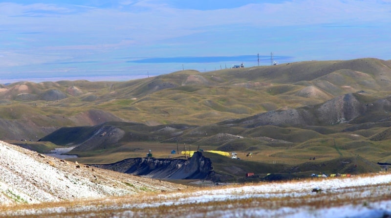
To the south of the pearl of Central Asia, as the Fergana Valley has long been called, there is a system of ridges, valleys and deep gorges filling a vast territory extending to the Pamir in the south. The Alai Range, the Alai Valley and the Trans-Alai Range are located here.
These three large orographic units are usually called Alai. Both ranges have much in common in their natural landscapes, which allows them to be distinguished into an independent mountainous region. One of the first researchers of the geological structure of Central Asia I.V. Mushketov (1886) in his classic work "Turkestan" came to the conclusion that the distribution of Tertiary-Cretaceous sediments proves that in the recent geological era, the mountain systems of the Tien Shan, Alai and Pamirs were completely divided among themselves.
Everywhere I.V. Muskets call this part of the then Turkestan the Pamir-Alai Mountains, or the system of mountains. Modern researchers on the question of the dissection of the mountains of Central Asia have different opinions.
L.S. Berg (1947) attributes almost the entire mountainous region in the southeast of Central Asia to the Tien Shan, separating only the Pamirs from it. Later researchers - S.S. Schultz (1948) and N.A. Gvozdetsky (1959) - the Fergana Valley is considered the border of the Tien Shan (in the south).
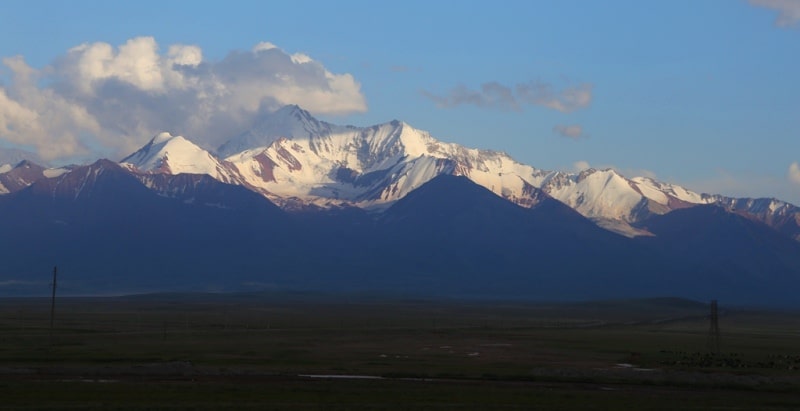
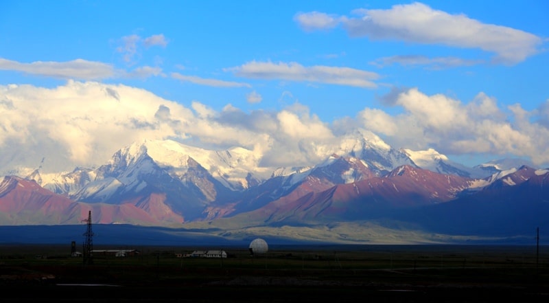
They distinguish more southern ridges into the Pamir-Alai system. The Trans-Alai ridge, in the central part of which (its highest point is Lenin Peak 7134.3 meters above sea level, forms the northern border of the Pamirs. This ridge stretches in a latitudinal direction for 150 kilometers and borders in the east with the extreme western spurs of Kokshaal-Too ( Tien Shan), and in the west it pinches out near the confluence of the Muksu and Kyzyl-Su rivers.
The heavily ice-covered northern slope of the ridge faces the Alai valley, above the southern side of which, at an absolute altitude of 6000 - 17000 meters above sea level, its slightly dissected ridge part rises. For a considerable distance, the average heights of the Zaalai Range exceed 6,000 meters above sea level, the southern slope facing the Pamirs rises 2,000 - 2,500 meters above sea level from the bottom of the high mountain valleys.
The ridge from the Alai Valley has a particularly majestic view. From above, three-quarters of its height, the slopes of the ridge are covered with massive snow. Only from below is the rocky base. The rocks that make up it have different colors - now black, then burgundy, then dark brown.
White streams of ice slide down from the snow covering the ridge. In the extreme east of the ridge, at the headwaters of the Eastern Kyzylsu rivers, the trapezoidal peak Zarya Vostoka rises with a height of 6346 meters above sea level.
To the right of it there is a huge snow massif of Kurumdy with a height of 6610 meters above sea level, translated into Russian as “visible”. Even more to the right, opposite the village of Sary-Tash, above a deep gorge, through which, according to old legends, the smugglers' trail went, the Pogranichnik peak rises 5434 meters above sea level.
Even to the west of the Pogranichnik peak lies a rather wide valley through which the Pamir Highway passes. The Korzhenevsky Mountains (the highest point of the ridge is 6075 meters above sea level), named after the tireless explorer of the Pamirs, lie west of the Pamir Highway.
The snow ridge of the Korzhenevsky mountains almost immediately turns into the giant Kyzylagyn peak, or the Red Stream, 6679 meters above sea level. Behind Kyzylagyn is the Barrikad ridge, and then Lenin Peak.
Behind Lenin Peak there are three, almost identical in shape, but different in height, peaks. They are named after Ilyich's closest associates - Dzerzhinsky, 6713 meters above sea level, Krasin, 5996 meters above sea level, and Tsuryupa, 5845 meters above sea level.
The last pointed peak of the visible part of the Zaalaysky ridge, rising in the form of a regular trapezoid, is named Sverdlov Peak 5451 meters above sea level, after the first President of the Soviet state. These names were given in early August 1928 by the leaders of the Soviet-German expedition N.P. Gorbunov, N.V. Krylenko and O. Yu. Schmidt, who made up the so-called "mining commission".
The members of the “mountain commission” assigned the names given by them to the corresponding protocol and instructed the surveyors of the expedition to accurately determine the location and heights of these peaks.
Behind the Sverdlov peak, the Zaalaysky ridge is cut by the Altyndara valley, to the west of it and the Tersagar pass, the ridge continues with a first-class rise with heights of more than 5000 meters above sea level.
At the western end of the ridge, the rivers Kyzylsu (from the Alai valley) and Muksu (from the Fedchenko glacier and the southern slopes of the Zaalaysky ridge) merge, forming the Surkhob river, which even lower takes the name Vakhsh and, joining with the Pyandj, forms the Amu Darya.
The slopes of the Zaalayskiy ridge are steep, cut by a system of short wide valleys, enclosed by almost sheer walls of circuses. Numerous glaciers descend along the valleys. In the Cenozoic era, the uplift of the Pamirs and its destruction began.
Low, at the beginning of the Paleogene era, the mountain heights of the Pamirs, as a result of general uplift and increased erosion, turned into huge rocky ridges with steep slopes and deeply cut gorges. This process ended in the Neogene with the strongest folds and uplift.
This main phase of alpine folding completed the formation of the fan-shaped folded structure of the North Pamir anticlinorium. The beginning of the formation of the Trans-Alai Range is also associated with the movements of that time.
The continuing rise of the Trans-Alai Range relative to the Alai Valley finds expression in the distinctly terraced river valleys within the mountains and the rapid decay of the terraces in the Alai Valley.The modern glaciation of the Trans-Alai Range is very significant and stands after such large glacial centers as Fedchenko (Pamir) and Inylchek (Tien Shan).
The weak dissection of the ridge of the Trans-Alai Range and the enormous absolute height have led to powerful modern glaciation. As in the past geological era, and at the present time, the highest point of the ridge, Lenin Peak, serves as the center, from which the largest glaciers of the Trans-Alai ridge spread in all directions, forming the main node of modern glaciation.
For 20 years, from 1945 to 1965, the glacial tongues underwent significant changes: they retreated. So, the Lenin glacier during this time retreated by 1300 meters, as a result of which there was a separation of its eastern and western branches.
It has lost 15% (compared to 1945) of its original length and 2.4 kilometers of square footage. If the thickness of the retreating part of the glacier is taken as an average of 20 meters, then the volume of ice melted over 20 years will be about 50 million cubic meters.
Since 1969, the glacier has begun to "advance" and may soon return to the 1950 position. This "advance" is a consequence of the sliding of firn-ice masses from the slopes as a result of the shrinking of the glacier.
The Oktyabrsky glacier, lying on the southern slope of the central part of the ridge, is one of the largest valley glaciers in Central Asia. It can be attributed to the type of "two-story" glaciers identified by K.K. Markov for the Pamirs and Visser for the Karakorum.
At present, the "young" pure white stream of the Oktyabrsky glacier cannot be considered a "second floor". He tore open an older glacier underneath and went deeper into the valley floor. Examination (plowing of its bed with a "young" glacier) dramatically changed the whole appearance of the Oktyabrsky glacier.
The plowing destroyed and separated from the living part about two-thirds of its width. Thus, the older glacier is no longer a "first floor" glacier. This glacier now lies higher than the middle living part of the stream, which has sunk into the bottom of the valley.
An older glacier, split into blocks, has almost lost its ability to move; it is rapidly collapsing and melting. The tongue of the Oktyabrsky glacier now makes up 30.3% of the area occupied by it in 1946. The modern relief of the flat part of the Alai valley is disturbed by relict formations of the ancient glaciation, which covered the whole of Alai.
In the eastern part of the valley adjacent to the Zaalayskiy ridge, the modern relief can be characterized as moraine-hilly. Here, vast areas (more than 250 square kilometers) are entirely occupied by the so-called "chukurs" - a random alternation of hills and depressions, characteristic of the surface of glacial tongues, which are in the stage of degradation (retreat).
This "gummy" relief was formed, apparently, in the penultimate phase of glaciation, after the glacial tongues crept into the valley. The period of the offensive was quickly followed by the opposite process. The tongues, deprived of the influx of ice, began to melt, leaving behind a hilly relief called the first researcher Alai A.P. Fedchenko "chukur".
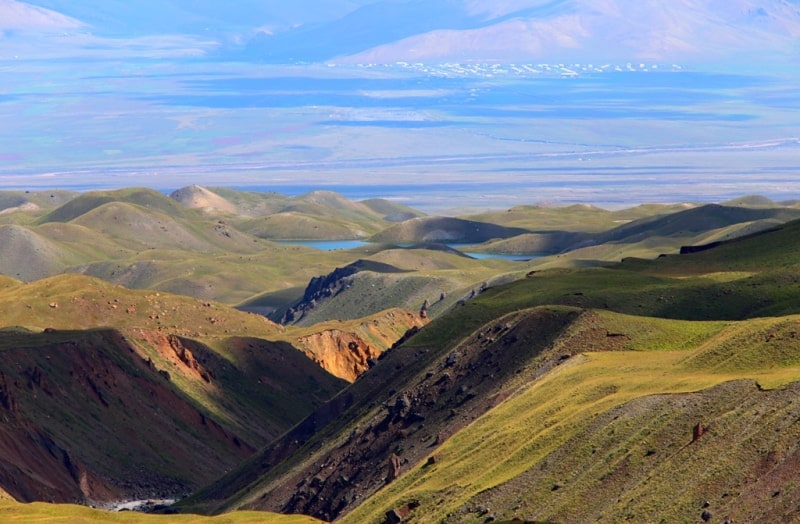
The Alai Valley, spreading at the foot of Lenin Peak, starts from the Taukmurun (Chicken Beak) cofferdam, which connects the Alai and Zaalaysky ridges with a low ridge. From the foot of this ridge (height 3378 meters above sea level), it stretches to the west for 135 kilometers.
Between the foothills of both ridges, the valley expands from 8-10 to 20-22 kilometers, its entire area is 1800 square kilometers. The lowermost part of the Alai Valley lies at an altitude of 2362 meters above sea level near the village of Katta-Karamyk.
In the glaciers and snowfields of the Alai and Zaalaysky ranges, streams originate, which merge with the Kyzylsu river flowing in the Alai valley. Behind the Taukmurun ridge is the source of another river with the same name. This river - Kyzylsu (Eastern) - flows into Kashgaria.
In terms of natural conditions, the Alai Valley can be divided into two almost equal halves - eastern and western. The temperature in the upper, eastern, part is about 2 - 2.5 ° lower than in the western part. Precipitation falls here much more - 720 - 750 mm (in Sary-Tash), and in the west - 540 mm (in Darautkurgan).
In terms of its landscape, the upper part of the valley is an alpine semi-desert. This part of the valley is characterized by fescue steppes with feather grass. The pebble steppe terraces, covered with a layer of fine earth, located in the western part, are characterized by wormwood formations, typical for semi-deserts.
If you look at the Alai valley from the Saryk-Mogol pass (the middle part of the Alai), then the eastern part of it will appear green, and the western one - yellowish-gray. The Alai valley serves as a good pasture for livestock.
From the north, through the Karakyzyk and Tengiz-Bai passes and a number of other less known routes, numerous livestock trails lead here. From the south, from the Eastern Pamirs, the Kyzylart pass is used to drive cattle.
Geographic coordinates of Alai Valley: N39°35'49.69" E72°54'52.96"

Authority:
"Kirghizia". Publishing house " Idea ". G.Moskva. 1970
Photos by
Alexander Petrov.