


![]()
Вы здесь
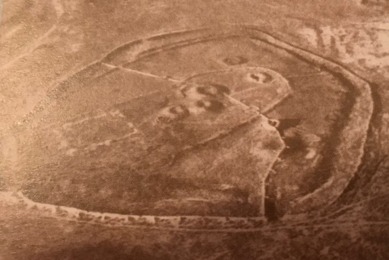
Ancient settlement Chirik-rabat.

Medieval cities of Kazakhstan on Great Silk way.
"The ruins of Chirp-rabat - a huge fortress dating back to the middle of the first millennium BC, which was surrounded by a system of concentric walls and ditches. It’s visible a rectangular layout later ancient fortress of the first centuries of our era"
S.P. Tolstoy.
History of Architecture and Construction of Kazakhstan.
The legendary settlement Chirik-rabat is situated 300 kilometers from Kyzylorda, on the left bank of the old river Janadarya. Archaeological monument Chiric-rabat has a scientific value as an object of several eras.
Settlement is a unique and well-preserved for studying to scientists. There is even a separate concept “Chirik-rabat culture”. Unique city belongs to the Saka period. It was built on a high hill, which raised the city above the flat plain and made it invulnerable to enemies.
Chirik-rabat occupies the entire area of the hill, area 850 х 600 m., from north to south. Settlement strengthened with powerful fortification system. At the bottom of the hill dug trench width up to 40 m., depth up to 4.5 m. The external powerful shaft surrounded from pit, up to 3 m, wide at the base to 8.10 m. Inner perimeter of the pit also built shaft.
The top of the hill surrounded by the third row of the shaft. The inner wall of the ancient city is girded today, severely damaged, but even now it reaches a height to 3 meters. The gallery passes inside the walls; hence, the archers could attack the enemy through special loopholes.
The city is well fortified that was virtually impregnable to enemies. According to archaeological research before the future site of the city was the necropolis of the Saks-apasiak. There are six high earthen mound in the surrounding area, under which were buried formidable Saks kings.
One of these mounds was excavated by scientists. Under the broad earth embankment was a grave, measuring 7.5 x 7.5 m and depth of 2.5 m. The walls were covered with clay plaster and whitewashed with lime. During the excavations revealed that the rectangular burial pit on the east or the west side, sometimes both at the same time, the burial chambers were constructed according to the type of the catacombs.
The entrances to the chamber was laid by clutch of adobe bricks. Three bone were found in one of the burial chamber. One of them was buried in fine clothes with gold ornaments and a long iron sword. The other two were stacked on wooden stretchers.
Next to them were found ceramic flask and censer, a vessel from pumpkins and other things. The maker's mark and the inscription of five characters were drawn on the flask. Apparently, they belonged to notable family. Burial was dated IV - II centuries BC.
Chirik-rabat ancient town was opened in 1946 by Khorezm archaeological expedition, which was led by S.P. Tolstoy. At that time the great temple, circular and rectangular burial structures were investigated. In addition, there were several pits in different parts of the settlement and the defensive wall.
S. Tolstoy described the ancient city in his book "In the wake of the Khorezm Expedition": "The ruins of Chirik-rabat - a huge fortress dating back to the middle of the first millennium BC, which was surrounded by a system of concentric walls and ditches.
It’s visible a rectangular layout later ancient fortress of the first centuries of our era." Under the state program “Cultural Heritage”, the research continued Chirik-rabat archaeological expedition which was led by Zh.Kurmankulov in the period 2004 - 2006.
Two funerary structures were unearthed and a large ring-shaped structure with a diameter of about 80 meters at the necropolis. Chirik-rabat archaeological excavation continues today. Kazakh scientists hope to open a new sensational discoveries that will help lift the curtain of history and to obtain new information about the life and culture of the ancient Kazakh people.
Geographic coordinates of Chirik-Rabat settlement: N44°05'14 E62°54'54
Authority:
http://culturemap.kz