


![]()
Вы здесь
Medieval town of Messerian
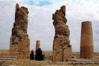
Excursions to Mashad-Messerian ancient settlement.
"130 name of the Allah, mercy, merciful! Blessing Allah that Abu Dzhafer Ahmed, the son of the Abu-l-Agara has ordered, the owner rabat, yes will glorify its Allah! Work Ali (son) Ziyada"
The text of an inscription has deciphered M.E.Massona, there is written.
Festival Turkmenistan tours.
The medieval town of Messerian is located at an altitude of 159 meters above sea level, located in the northern part of the Masserian plain and in the southern part of the Choganli plain, in the northwestern part of the Khurmen sands, 17.6 kilometers north-west of the village of Madau, 43 kilometers on northeast of the small village of Indyrlan and 141 kilometers south and slightly east of the city of Balkanabat in the Etrek etrap of the Balkan velayat.
The medieval city of Messerian, which gave the name to the vast plain, which was part of the system of the Khorezmshah state, was one of the major trade and craft centers of ancient Dehistan (the country of the Dakhs).
Dehistan or Mashad-Messerian is an ancient city consisting of a large Mashad cemetery with the Shir-Kabir mausoleum of the X century, and the ruins of the city of Messerian of the X - XV centuries. Founded at the end of the IIIrd century BC e. and blossomed under the rule of the Khorezmshah dynasty.
It was destroyed by the Mongols, then revived again. It existed until about the XIV century. e. Dehistan was part of a vast cultural complex that included the Gorgan Plain in northern Iran. The material culture of the Iron Age on the Messerian and Gorgan Plains is identical and of the same age.
The Messerian Plain is one of the most unusual places on the territory of Turkmenistan. There was no intensive construction here, these lands are also of little use for agricultural work, therefore, many historical monuments have been preserved here.
The earliest traces of human activity on these once fertile lands date back to the middle of the IInd millennium BC. At that time, there were the largest settlements of ancient civilizations - Madau-Depe, Izzatkuli and Tangsykylja, and there was the most powerful irrigation system in all of Central Asia.
This historical area, commonly known as Hyrcania, flourished under the Achaemenids, during the Parthian era, under the Sassanids, and reached its peak during the Islamic period. The ruins of the once brilliant cities of Djurdjan and Dehistan have survived to this day, but scientists believe that the sands of the desert hide many more unknowns.
The settlement of Mashad belongs to the settlement of Dehistan, there is another name for the settlement - Mashad-Messerian. During the invasion of the Mongols, it was destroyed by them, then revived again. But with the departure from these lands, the waters (once upon a time the ancient channel of the Uzboy flowed here) finally fell into decay and became empty.
xcavations helped to find traces of artisan quarters, several mosques, caravanserais, as well as the remains of a developed water supply system: irrigation canals, canals, even sewers. The inhabitants practiced agriculture, as evidenced by the widespread irrigation system.
Household items - bronze lamps, painted faience products. It is noteworthy that during construction, the inhabitants of Dehistan used burnt bricks, while in other cities of that era, raw bricks were most often used for this.
Geographic coordinates of the ancient town of Messerian: N38 ° 15'58.91 "E54 ° 37'19.25"
Authority:
On materials of an information department of the State committee of Turkmenistan on tourism and sports. «Religious and spiritual monuments of the Central Asia ». The author of M. Khashimov. Publishing house "Saga", 2001.