


![]()
Вы здесь
Kara-Kum Desert.


Tours on jeeps across Kara Kum Desert.
“Night poured over the desert. It came suddenly, in purple. In the clear air, the stars drilled down out of the sky, reminding any thoughtful watcher that it is in the deserts and high places that religions are generated. When men see nothing but bottomless infinity over their heads they have always had a driving and desperate urge to find someone to put in the wa”
Terry Pratchett, “Jingo”.
Travel on Kara Kum Desert.
Karakum Desert is located in the central part of Turkmenistan in the Akhal, Balkan and Dashoguz velayats and in the western part of Uzbekistan in the Khorezm and Bukhara regions and the Republic of Karakalpakstan.
"Karakum" in translation from Turkic means, according to E. M. Murzaev, "earthen sands". In the northeast, the desert is bounded by the Amu Darya valley, in the southeast and southwest, it gradually turns into the Badkhyz and Karabil foothills and into the sloping plains of the Kopet-Dag foothills.
In the west and north-west, the border is formed by the dry channel Uzboy and the Sarykamysh depression. E.M. Murzaev distinguishes five regions in the Karakum physical-geographical region allocated to him: Zaunguz (Northern) Karakum, Low, or Southern, Karakum, areas of the foothill plains of the Prikopetdag and Parapamizskaya and the Caspian plain (Southwestern Karakum).
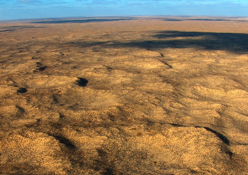
The Zaunguz, or Northern, Karakums are located north of the chain of dry Unguz depressions. Southeastern Karakum is located on the territory of Lebap and Mary velayats. Turkmenistan. The Karakum is the most extensive sandy desert with an area of about 300,000 square kilometers.
Relief of Karakum Desert.
According to the relief, the desert is divided into two parts. The smaller, northern part is occupied by the Zaunguz Karakum, or the Zaunguz plateau, which in the south is bounded by a steep 60 - 80 meter high ledge dissected into flat-topped ridges.
At the foot of this ledge, there is a chain of Unguz saline depressions, which are the remains of an ancient river channel deformed by tectonic movements and processed by desert continental agents. A much fresher channel of the ancient river channel of the Amu Darya is the Uzboy bordering the Karakum Desert from the northwest, which dried up, but retained all the morphological features of the river valley.
To the south of Unguz, the spaces of the Central, Southeastern and Southern Karakum Desert stretch, which together form the second, most part of the desert. The Central Karakum in relation to the stage of the Zaunguz Karakum represents a lower plane, which is why they are often called the Low-lying Karakum.
To the south and southeast, the surface gradually rises, and the plains of the Southern and Southeastern Karakum Desert lie at higher elevations than the Zaunguz plateau. The surfaces of both planes forming the step are slightly inclined to the west.
In the Southeastern Karakum there is a dry bed of an ancient river channel - the Kelif Uzboy, a significant part of which is now occupied by the Karakum canal. The Zaunguzian plateau is formed in the upper part by sandstones and clay-sandy deposits of the Paleo-Amu Darya, which flowed here in the Miocene - Pliocene.
Between the scarp of the Zaunguz plateau and the Kopetdag, the waters of the ancient Amu Darya flowed from east to west in the Lower Quaternary, the spaces of the Central and Southeastern Karakum desert are lined with alluvium. In the southern part of the Karakum Desert, deltaic deposits of the Tejen and Murgab rivers are superimposed on it.
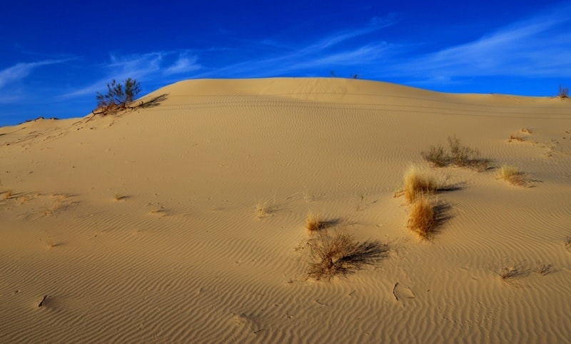
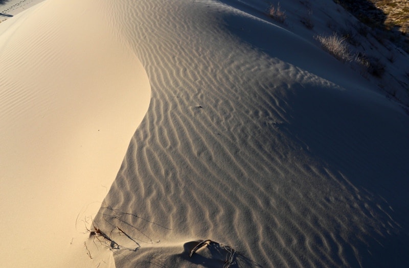
The aeolian relief of the desert is dominated by ridge sands, in the south turning into hilly (small ridge) sands, among which there are flat clay areas - takyrs. Most of the sands are fixed by vegetation. Loose, dune sands occupy about 5% of the area, mainly in the South-Eastern Karakum Desert.
The submontane plains of the Karakum are a transitional zone between the plains of the Karakum and the mountains bordering them. Genetically, they are closely related to the mountains, and in terms of the nature of the relief and in terms of heights, they have much in common with the plains.
The submontane plains are composed mainly of proluvial and deluvial materials; loesses and loesslike deposits play an important role in the structure of the surface. Intense tectonic movements, continuing at the present time, explain the relatively large slope of the plains, and the removal of proluvial material on them determines the youth of the relief.
The Kopet-Dag piedmont plain borders the foothills of the northern and western slopes of the Kopet-Dag in a continuous strip. The width of the plain varies from several kilometers to several tens of kilometers, the height of its surface ranges from 350 meters (in the west) to 50 meters (in the east).
Typical piedmont plains include the Karabil and Badkhyz hills - the foothills of the Parapamiz range system located in Afghanistan. This piedmont plain is distinguished by relatively high absolute heights (Karabil - up to 979 meters above sea level, Badkhyz - about 800 meters above sea level) and a significant general slope of the surface to the northwest (up to 8-10 meters per 1 kilometer).
The uplifted sloping plain is poorly dissected; the valleys of the recently dead hydrographic network are shallow and gently sloping. The Badkhyz Upland is characterized by drainless depressions. The Caspian plain (Southwestern Karakum) by the nature of the relief has much in common with the Southern Karakum, with which it is connected by a narrow Bal Khan corridor.
Ridge sands are also widespread here, but the area occupied by them is somewhat smaller. Significant spaces are formed by takyrs. In the western part of the plain, there are salt marshes - blinders. A strip of young, recently formed land stretches along the coast of the Caspian, which is explained by a decrease in the level of the reservoir.
From Kopet-Dag in the northern direction in the Karakum Desert, one can trace a successive change of different soils, their zonal distribution. Within the piedmont sloping plain, strips of soil quickly replace each other: gravelly-pebble, loamy, takyr.
This is followed by a strip of enormous width, predominantly of ridge sands. Behind Unguz to the north lies a strip of kyrs, again giving way to ridge sands. To the north of the Zaunguz Karakum there is a strip of sandy-loamy Upper Quaternary deltas of the Amu Darya.
Geology of Karakum Desert.
As the plains of Central Asia were freed from sea waters in the post-Sarmatian period, the Northern Karakum Desert became dry land earlier than other of the listed regions. The flat surface of the Northern Karakum desert is gradually decreasing in a northern direction, towards the ancient valleys of the Amu Darya.
Their southern edge forms a ledge with a height of 50 - 80 meters. At the foot of the ledge, there are closed hollows of the Unguz, occupied by salt marshes, takyrs, and in the eastern part by sands; the depth of the depressions in relation to the precipice is 80 meters, and in relation to the level of the sands lying to the south of the chain of hollows - 20 - 40 meters.
The sizes of the diameters of the depressions are from several hundred meters to 15 - 20 kilometers, they are formed in bedrocks, which are also composed of the bridges separating the depressions. The formation of the ledge, the southern cliff of the Zaunguz Karakum, is associated with tectonic reasons - with the formation of a fault, or flexure, which separated the Northern Karakum from the South.
The closed depressions of the Unguz at the foot of the cliff were formed as a result of karst-suffusion and aeolian processes. It is also possible that the band of the Unguz depressions was formed as a result of deformation of one of the Pra-Amu-Darya old rheumans, but at present there are no morphological signs of a river valley or channel here.
The Zaunguz Karakum is composed of upper Tertiary Pliocene continental sediments - dense variegated colored sandstones with interlayers of clays, the so-called Zaunguz strata. The same breeds are distributed south of Unguz, in the northern part of the South-Eastern Karakum Desert and on both sides of the river.
Amu Darya in its middle reaches. A sulfur deposit is confined to the sandstones of the Zaunguz strata. From the surface, the sandstone stratum is covered with sand, but often, especially in the southern and western regions, it comes to the surface.
The surface of the Zaunguz Karakum is occupied by ridges. In the western and southern parts, the ridge is composed of Zaunguzian rocks; the relative height of the ridges is up to 75 meters, the length is 5 - 8 kilometers and up to 20 kilometers, and the width of the summit surfaces is about 1 kilometer, the width of the depressions between the ridges is usually 0.5, sometimes 3-4 kilometers.
These ridges are called kyrs. The top surfaces of kyrs are covered with rubble. In the northern direction, there is a gradual decrease in the ridges, they are more and more covered with sand. Between the kyrs, in elongated depressions, there are small sandy ridges, takyrs and blinders. Ridge sands are widespread throughout the Zaunguz Karakum, but in the northern part their number is especially large.
Along the middle course of the Amu Darya and in the northern part of the Southeastern Karakum Desert, where the Zaunguz strata comes to the surface, there is a similar kyr relief.
Soils of the Karakum Desert.
In different parts of the Karakum, the soils are not the same: in the Zaunguz and Southern Karakum soils are gray-brown desert and takyr, often saline; in the Southeastern Karakum there are gray soils, sandy, sandy loam and on light loam.
The degree of their salinity is different.
The Kopetdag foothill sloping plain is characterized by a frequent change of soils not only in strips differing from each other in the composition of deposits and stretching parallel to the mountains, but also within the strips themselves. A narrow strip of salt marshes and takyrs stretches along the northern edge of the plain at the border with the sands.
Closer to the mountains, there is a strip of takyrs on heavy loams, clayey takyrs and takyr-like serozem soils; all these formations are saline to varying degrees. Further there is a strip of sierozem - loamy and gypsum-bearing, developing on proluvial material. Saz-meadow soils and plump salt marshes are associated with groundwater outlets.
On the piedmont plain there are irrigated lands - sierozem and takyr. The surface of the Karakum desert consists of fixed and mostly semi-fixed by vegetation, ridge, small-bed, ridge-hilly and hilly sands. They are unusually flowery in a short spring: sand sedge - ilyak - covers the sands, and against its background colored ephemera and ephemeroids are scattered.
At the end of April or at the very beginning of May, the vegetation burns out, becomes dark brown, grayish with dust. After a short spring period of rapid growth and flowering, a long hot dry summer sets in, the plants fall into a state of dormancy, often turning into a state of winter dormancy.
The Karakum desert becomes grayish-brown, with dark spots, stripes of plants burnt in the sun. They are like this almost all year.
Hydrography in Karakum Desert.
The Karakum Desert is crossed by the dry channels of the Uzboy and Kelif Uzboy. Uzboy is a typical ancient rare valley with a well-defined channel, alluvial deposits, and a system of terraces. Uzboy begins on the southern outskirts of the Sarykamysh depression and extends to the Caspian Sea, to the huge Kölker salt marsh, formed on the site of the bay.
The length of Uzboy is 550 kilometers, the width varies from 200 meters to 4 kilometers, and the depth is 40-50 meters. The total drop of the channel is 75 meters. In the channel of the Uzboy there are fresh and salt lakes, which feed mainly on groundwater; some of them probably represent oxbows.
There are many wells. Where Uzboy crosses limestone outcrops, rapids up to 7 meters or more are formed. In some places, saxaul thickets grow in the riverbed of the Uzboy. From the Kölker salt marsh to the Caspian there is the Aktam channel, which is occupied by salt lakes.
With a wind from the Caspian side, water can penetrate upward along the channel for several tens of kilometers. Kelif Uzboy is one of the ancient branches of the Amu Darya, crossing the Karakum in the southeastern part for about 250 km. The channel of the Kelif Uzboy in comparison with the channel of the Uzboy is weakly expressed and represents a chain of elongated depressions, in places separated by sandy bridges.
The bottom of the depressions is usually covered with salt marshes (blinders). The Karakum Canal runs along the bed of the Kelif Uzboy. The groundwater in the central parts of the desert is highly mineralized, but where the waters of the Amu Darya, Murgab, Tejen and rivers of the Kopetdag foothills seep into the sands, weakly saline groundwater is common.
As a result of hydrogeological research in recent years, large reserves of fresh groundwater have been discovered in the east and southeast of the desert, freshwater lenses in the Zaunguz Karakum Desert. In the desert there are many dug wells (more than 10,000), and in areas devoid of fresh groundwater, filling wells (chirle) are arranged, into which fresh rainwater is collected from takyrs.
It saturates the sand column by forming lenses on top of the denser, salty groundwater. The soil and vegetation cover and the fauna of the Karakum Desert in essence have already been described above, with a general description of the southern sandy deserts.
The largest canal in Turkmenistan, the Karakum canal, has been built in the Karakum Desert. Plantations of cotton, alfalfa and other valuable agricultural crops have been created on the lands irrigated by the canal waters. Sericulture, horticulture and viticulture are further developed.
In the zone of the canal, pastures have been watered, and the fodder base of animal husbandry is expanding. The channel is also used for transport purposes.
Vegetation of Karakum Desert.
For the Karakum desert, in comparison with other sandy deserts, the intensive development of spring ephemeral vegetation is especially typical. Almost all of their territory, with the exception of the dune sands, is covered in spring with a green carpet of ephemerals and ephemeroids, among which sand sedge silt, a valuable forage plant, predominates.
White and black saxaul are found on the overgrown sands. Seleu and shrubs are characteristic of the overgrown dune sands: sandy acacia, kandyms (dzhuzguns). Plants in the Karakum Desert are settled depending on the relief of the sands, the composition and properties of soils and hydrogeological conditions.
Complexity is observed in the vegetation cover of the Karakum Desert. The complex is more often three-membered, consisting of plants tops of ridges and hillocks, their slopes and depressions between them. On the tops of ridges and mounds grow: perennial turf grass selin (Aristida karelini), species of dzhusgun (Calligonus Caput Medusae, C. elatum, C. arborescens), sand acacia - suzen (Ammodendron conollyi).
These plants are the pioneers of sands: they are the first to settle on loose, moving sands. The tops of ridges and hillocks are composed of the least bonded sands, overwhelmed and redeposited, with centers of secondary waving. On the slopes of the ridges grow: white saxaul (Haloxylon persicum), dzhusgun species, treelike hodgepodge - Cherkez (Salsola Richteri), ephedra (Erhedrastrobilacea).
On the slopes of ridges and hillocks, sand is held together by clay particles and compacted in the surface horizon. More plants settle on them, the number of their species is greater. The same applies to the number of individuals. Between the bushes of white saxaul, dzhusgun, cherkez, there is a sand sedge - silt (Carex physodes), which is of paramount importance as a fodder plant. In addition to sand sedge, Poa bulbosa usually grows on the slopes; in the spring, ephemeral annuals develop rapidly.
In the ridge depressions, the sand is the most compacted and cemented. Sand sedge grows quite densely in them and numerous annuals are common: eastern wheatgrass (Eremopyrum orientale), roofing grass (Bromus tectorum), poppy (Papaver pavonium), etc. ) and other hodgepodge.
Tortula desertorum) and lichens; from the former vegetation, only a few specimens remain. A dense, cemented crust on the sands forms in areas not used for grazing, which prevents its formation. Moderate grazing of livestock favorably affects the condition of the vegetation of the sands and the condition of pastures in sandy deserts.
Excessive grazing of livestock and the destruction of bushes during harvesting for fuel lead to the secondary waving of fixed sands. In the Zaunguz Karakum, a group of plants is widespread on the kyrs, consisting of white saxaul (Haloxylon persicum), Circassian (Salsola Richteri), rheumuria (Reaumuria oxiana) and boyalych (Salsola arbuscula); this group of plants is mixed with feather grass (Stipa Szowitsi ana), bindweed (Convolvulus Korolkowii) and ephemera.
The Badkhyz and Karabil uplands are covered with grass-sedge and ephemeral-wormwood vegetation; umbellate plants - ferula (Ferula badrakema, F. Aitchisonii), reaching very large sizes, are often found. Badkhyz is characterized by rare persistent, sparse plantings of pistachio (Pictacia Vera).
Badkhyz and Karabil are used as pastures for Karakul sheep. On the foothill plains of the Kopetdag, large areas are occupied by takyrs. In spring and to a lesser extent in autumn, blue-green algae develop from them, covering them with a film consisting of plaits of algae from the genus Microcoleus.
In addition to algae, lichens settle on takyrs, then annual saltwort and ephemera, then perennials, mainly ephemeroids, and wormwood (Artemisia badghisi) settles last. The overgrowth of takyrs, typical for the piedmont plain, occurs v with unequal intensity in some of its areas.
This allows you to trace the successive steps in this process. Takyrs, located among the sands, cease to exist after they are covered with sand. For the Caspian lowland, covered over large areas with salt marshes, succulent solyanka dwarf shrubs are typical: sarsazan (Halocnemum strobilaceum), carabarak (Halostachys caspica), potash (Kalidium caspicum).
The sand flora was formed in the Quaternary and post-Quaternary times. It is much younger than the flora of salt marshes, which began to develop in the Tertiary time and inherited from the flora of the sea coasts and shallow waters (littoral).
Mineral resources of Karakum desert.
In the Karakum there are deposits of various mineral waters, large reserves of potash and table salt have been discovered. In the center of the desert, in the Unguz region, deposits of high-quality sulfur have been developed since 1929.
In some places, gas and oil have been found.
Finding large gas fields Darvaza-Zeagli in the Central Karakum Desert. The Ochak gas field is located in the Zaunguz Karakum Desert, the Bayram-Aliyskoye field in the South-Eastern Karakum Desert (there is also oil here). In the vicinity of the western part of the Karakum Desert, in the coastal desert regions of western Turkmenistan, a number of oil and gas fields are exploited - in Nebit-Dag, Kum-Dag, Koturdepe, on the Cheleken peninsula, etc.
Origin of Karakum desert.
Most of the sands in the deserts of Central Asia were formed as a result of rewinding of ancient alluvial Quaternary sandy and sandy-clayey deposits. In the southern zone (subtropical deserts) these are the sands of the Central and Southern Karakum, the sands of the northeastern, Syrdarya, part of the Kyzylkum desert.
A relatively small part of the sands arose as a result of weathering and further rewinding of sandstones (the western part of the Zaunguz Karakum Desert, the central and southwestern parts of the Kyzyl Kum desert). There are sands, which are siphoned lacustrine sediments.
Thanks to aeolian processing, the sands of the Central Asian deserts are well sorted. These are fine-grained sands, 90 - 99% consisting of a fraction of 0.05 - 0.25 mm. The color of the sands depends on the age of waving, the duration of their processing by atmospheric agents.
Ancient alluvial sands in the deserts of Central Asia are usually gray, but when they enter the sphere of soil formation, they acquire a yellowish-brown hue due to iron hydroxides. The longer the sands are on the surface, the more they turn yellow.
Sands of the Zaunguz Karakum, for example, exposed to waving and the action of soil processes since the Pliocene, are more yellow than the Upper Quaternary sands of the Central Karakum. It is necessary to clearly distinguish between the issues of the origin of sands and the origin of forms of sandy relief in deserts. In relation to the deserts of Central Asia, the question of the origin of the relief of the sands was subject to discussion in the pre-war years.
Many researchers denied the specificity of the relief of sandy deserts and the role of wind in the formation of the relief of overgrown sands. Various origins were attributed to the ridge overgrown sands of the Karakum: they were considered as erosion-accumulative formations of meridional water flows, they wrote about the karst or suffusion-karst origin of the inter ridge basins.
There was even an assumption (PS Makeev) about the tectonic origin of the meridional ridges of the Karakum Desert. Low-lying, or Southern, Karakum Desert is also composed of continental sediments, but of Quaternary age. The thickness of the sandy-clayey deposits of the Karakum strata is about 100 m, and in the southwestern part of the Karakum it is measured in thousands of meters.
This stratum serves as a reservoir for known oil and gas fields. In this area, a vigorous manifestation of tectonic movements in the Quaternary and post-Quaternary times was recorded, manifested in the uplift of the Khvalynian terraces (on Boydag - up to 100 m absolute height) and oil structures.
The formation of the Karakum sequence occurred as a result of filling a large depression with alluvial material. Since sediment formation in the Southern Karakum took place later than in the Northern Karakum, the sediments here under the influence of diagenesis remained almost unchanged.
The Zaunguzian continental stratum, which is very similar in origin to the South Karakum one, on the contrary, has changed greatly under the influence of diagenesis. The accumulation of the South Karakum sandy-argillaceous strata occurred during a period of very vigorous erosion of mountains and the removal of material by rivers to the plains.
This period is associated with the ancient glaciation of the mountains framing the plains from the south and east in the Upper Tertiary and Quaternary. The Amu Darya flowed through the Southern Karakum, south of Unguz. The tributaries from the Kopet-Dag - Tejen and Murghab, flowed into it, the rivers of northern Afghanistan - Zeravshan with Kashkadarya.
The Amu-Darya and its tributaries carried clastic material from the mountains and deposited it in the areas of the Southern Karakum Desert tributaries separated from the Amu-Darya vigorously formed their deltas, and then, as the glaciation in the mountains decreased, the runoff decreased, the length of the rivers decreased, and the retreat of the latter was accompanied by the formation of each river deltas series.
These ideas are quite consistent with the stratigraphy of the Karakum strata, for example, in the section of the Obruchevskaya steppe, composed of deltaic sediments of the rivers of northern Afghanistan. (The Obruchevskaya steppe is located south and southwest of the Kelif Uzboy).
Karakum loose the stratum is also characterized by the fact that it is comparatively more sandy in contrast to the Kyzylkum, more fine-earth clay strata. This is due to the fact that the ramified network of tributaries of the Amu Darya with extraordinary energy eroded the high mountains of the Western Pamir and Pamir-Alai and managed to deeply dissect them.
At the same time, the products of destruction were carried directly to the Karakum Desert. This process is taking place with less intensity at the present time. The highlands of Kuhistan, the Western Pamir and the low mountains of the Southwestern Pamir were and remain the main territories from which material is transported to the Karakum Desert.
Ancient (Quaternary) alluvial deposits form the basis of the Karakum strata. But sandy and sandy-argillaceous deposits, formed in the process of physical weathering of bedrocks, also take part in its structure. As a result of the rewinding of the Karakum strata, the sands of the Karakum were formed.
The use of aviation contributed to the elucidation of the origin of the relief forms of sandy deserts. With the help of observations from an airplane and aerial photography, large areas of sandy deserts were mapped and the specificity of the relief of the sands, associated with their flowability and aeolian transportation, was undoubtedly established.
With the help of aerial photography and visual observations from an airplane, a wide development in the sandy deserts of Central Asia of ridge relief forms, parallel to the prevailing winds, was established, and a tendency was noted for the restructuring of forms perpendicular to the prevailing wind into parallel ones.
The formation of the sand ridge relief, which is the main type, and its features, according to B. A. Fedorovich, are associated with vortex air currents and dynamic phenomena that arise at the border of two mobile media, in this case, air and sand.
A clear proof of the aeolian nature of ridge relief forms is the bending of ridges of outlying hills in the desert (for example, in the sands of Kyzyl Kum), just as these hills are bent around by air currents.
Climate of Karakum desert.
The climatic conditions in the Karakum Desert are not the same in their different parts. The differences arose due to the great length of the Karakum Desert, both from west to east and from north to south. In the western part of the region, the Caspian Sea has a moderating effect on the course of air temperature throughout the year; in summer the air temperature decreases slightly (the average temperature in July is +28, +29 °) compared to the eastern outskirts (the average temperature in July is +30, + 32 ° in Termez), and in winter, on the contrary, it rises (the average temperature in January is about + 2 ° ) compared to the central and northern parts (average January temperature -2, -5 °).
In the southern part of the region, the average monthly temperature in January is above zero, and in the northern part it is about -5 °, but there are sometimes days with temperatures as low as -29 ° and even lower. The daily amplitudes of air temperature reach + 50 °, and on the ground up to + 80 °.
Only the southern part of the Caspian lowland is protected by the western spurs of the Kopet-Dag from the invasions of the Arctic air masses. The rest of the region, due to low winter temperatures, is unsuitable for the cultivation of subtropical crops.
The frost-free period lasts more than 200 days on average. The greatest amount of precipitation falls in March - up to 24 mm out of 100 mm falling during the year. In summer, precipitation is rare, but in August, as a rule, there is no precipitation at all. In the strip of the piedmont plain, the annual precipitation exceeds 200 mm.
The Karakum desert is characterized by low cloudiness, especially in summer, a huge amount of solar heat, dry air and evaporation, many times higher than the annual precipitation.
Pastures in Karakum Desert.
Huge areas in the Karakum Desert are used for year-round pastures. State farms are engaged in breeding sheep, goats and camels. There are also many collective farm livestock farms. For livestock in the Karakum Desert, roughage is prepared annually, and reserve forages are created in the inland regions.
Several thousand wells have been built over the past two decades. In the breeding farms, work is underway to improve the quality of valuable breeds of sheep - Karakul smushkovaya and Saraja meat and wool sheep. There are tribal camel-breeding state farms.
The Karakum are vast pastures where Karakul sheep, goats and camels are grazed. Most of these pastures are used all year round. In the places of grazing of the main flocks of sheep, reserve fodder resources are created, new wells are built.
To expand the area of agricultural oases and water supply to the southern part of the desert, the Karakum Canal was created. Topical issues are the introduction of pasture rotation, improvement of pastures, the prohibition of cutting saxaul and shrubs.
Sandy deserts are used as pastures: here the best conditions for grazing Karakul sheep. An important feature of sandy deserts as pastures is the ability to use them throughout the year. In spring and summer, sand sedge is the main food plant.
In autumn, the main food is dwarf shrubs and shrubs, eaten by the main in the image of sheep and camels; Astragalus, saltwort, ephedra, juzgun, saxaul, etc. are of fodder importance. In winter, saltwort and various dwarf shrubs serve as food; shrubs lose their leaves by winter and are eaten only by camels.
All year round, the cereal Seleu (Selin) is of great fodder value. So, pastures of sandy deserts, in comparison with other types of deserts, are distinguished by high productivity, good quality of forage plants, availability of forage in winter, which is critical for cattle breeding, and relatively low dependence on weather conditions.
Even in the driest years, sandy pastures have ample forage. In such years, annual grasses do not appear, which, of course, affects the productivity of pastures. Moderate regulated grazing of livestock not only does not harm the vegetation of sandy deserts, but is even beneficial, since livestock loosens the top layer of sand and destroys the crust formed in the silty sands, which improves the hydrological regime of the sands. In the Karakum Desert, in areas of excessively weak grazing, mosses develop (the Turkmens call them "karaharsang"), oppressing herbaceous vegetation.
Many plants of sandy deserts are used to fix moving sands that approach oases, fill fields, gardens and buildings, bring roads, etc. M.P. Petrov, 1950). The wood of shrubs and trees of the sandy desert is not suitable for handicrafts, as it is fragile and silvery, but it is a high-calorie fuel.
The looseness of the sandy substrate provides some convenience for the life of animals in the desert, allowing them to easily bury themselves in the sand, but at the same time, movement on loose sand requires special adaptations.
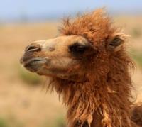
Fauna of Karakum Desert.
The fauna of the Karakum region is rich: it is dominated by psammophiles. In the extreme south of the Karakum Desert, the fauna is distinguished by the fact that representatives of the fauna of India, Iran and Afghanistan take part in it.
Therefore, the Kopet-Dag and Murgabo-Tezhen districts belong to the province of the Iranian-Afghan highlands, and not to the desert Turkmen.
Animals from the south spread to the mountains, to the foothill plains, along the river valleys, to the pistachio forests of Badkhyz and to a narrow strip of the plain adjoining the foothill plains. In the mountains and foothills, numerous birds and mammals have penetrated from the neighboring southern province.
In the river valleys live: Indian lapwing, ringed turtledove, scaly woodpecker, starling myna. In the strip of plains adjacent to the foothills, there are: Indian honey badger, cheetah, Gdena, Afghan vole; many poisonous snakes (gyurza, efa, cobra).
The Indian shrike lives in the thickets of the Badkhyz pistachio. For the Karakum Desert, as well as for other sandy deserts, the fine-toed ground squirrel (Spermophilopsis leptodactylus) is characteristic, digging large burrows on the slopes of the dunes; the main food of the gopher is viviparous bluegrass.
The great gerbil (Rhombomus opimus) forms large colonies in hilly sands; she prepares hay by stacking it in stacks. For spaces of sands, jerboas are also typical - Uplifted (Dipus sagitta) and Ridge-toed (Paradipus stenodactylus); they feed on grasses, tubers, seeds, roots, eat insects; animals are active at night.
From ungulates in the peaks live gazelles, from predators - wolf, lice-corsac, sand cat, caracal. There are also many birds in the sands: saxaul jay (Podocespanderi), saxaul sparrow (Passer ammodendri), desert warbler (Sylvia nana), desert wheatear (Oenanthe deserti), desert shrike (Lanius excubitor), desert crow (Corvus) larks.
Even more reptiles live in the sands. The eared roundhead (Phrynocephalus mystaceus), which feeds on insects and small lizards, is characteristic. The Turkestan agama (Agama sanguinolenta) is often found. In the daytime, agamas climb the bushes, since the temperature at a height of 2 meters is 28 ° lower than the soil temperature in the sun and 10 ° in the shade.
There are many small lizards - sandy roundheads (Phrynocephalusinterscapularis), reticulate and striped lizards (Scapteira grammica, S. scripta). The largest lizard, the gray monitor lizard (Varanus griseus), is a predator that feeds on snakes, lizards, birds, eggs, and small rodents.
Of the snakes, usually on saxaul bushes, there is a thin and long arrow-snake (Trphrometopon lineolatum), which eats lizards, phalanges; steppe boa constrictor (Eryx miliaris) is a typical animal of the sands, feeding on rodents, birds (chicks), lizards, insects.
In the Karakum Desert, especially in the South, there are many poisonous snakes (efa, cobra, gyurza). Insects are characteristic of the sands: sand beetles, darkling beetles, wingless ground beetles. Of the arachnids, scorpions and phalanges are often found. There are many rodents in the sandy desert.
Of these, the following are especially characteristic: the fine-toed ground squirrel (Spermophilopsis leptodactylus), leading a solitary lifestyle; the great gerbil (Rhombomys opimus), which lives in colonies; nocturnal animals - small, or midday, gerbil (Pallasiomys meridianus); Upland jerboa (Dipus sagitta), the leap length of which is 10-12 times longer than the length of the animal itself.
The bipedal jerboa, like the less common crested jerboa (Paradipus ctenodactylus) and some others, has a brush of elastic hair on the toes of the hind limbs, which prevents the feet from diving into loose sand when jumping. From the order of insectivores for sandy deserts, the eared hedgehog (Hemiechinus auritus) is characteristic, which also eats poisonous snakes.
Of the ungulates, the gazelle antelope lives. Among the birds there are species that are characteristic only of sandy deserts, for example, the saxaul jay (Podoces panderi), a rapidly running bird. A small sand-colored desert warbler (Sylvia nana) lives here.
The sparrow of Zarudny living in the sands of the Karakum desert is of the same color. There are also crested larks. Driving along the Trans-Caspian railway through the Karakum Desert, one can see larks sitting in the shade of telegraph poles.
As the shadow moves, so do the birds. There are also desert shrike (Lanius excubitor pallidirostris), desert chisel (Oenanthe deserti) imitating the voices of various animals and birds, desert crow (Corvus ruficollis), large predator buzzard buzzard (Buteo rufinus).
Sandy deserts are characterized by an abundance of reptiles. Lizards are found here: small sandy roundhead (Phrynocephalus interscapularis); a larger eared roundhead (Ph. mystaceus), which can be seen at the top of a dune or hillock, where it usually stands on extended legs with a tail bent upwards, blown by the breeze; Turkestan agama (Agama sanguinolenta), which escapes from the hot sand on the tops of the bushes.
There is a giant lizard, the gray monitor lizard (Varanus griseus) up to 1.5 m long. Of the snakes, the sand boa constrictor (Eryx miliaris) of small size (up to 75 cm) is interesting. It clasps its prey (gerbils and other animals) with strong rings, strangles and swallows it whole.
A poisonous, but not dangerous for human life arrow-snake (Taphrometopon lineolatum), invisible among the bushes, acts quickly and deftly. There is a poisonous sandy ephae (Echis carinatus). Among insects in the sandy desert live darkling beetles (Sternodes caspica, etc.), dung beetles, etc.
Of the arachnids, phalanxes and scorpions are numerous. Even from a brief overview of the features of the nature of sandy deserts, it can be concluded that these deserts, which have peculiar forms of aeolian relief, sandy low-humus soils, adapted to exist on a loose substrate with psammophytic vegetation and a peculiar fauna adapted to life in sands, represent a very special geographic complex.
Its specificity and differences from other subtypes of the desert landscape are determined by the sandy substrate.
Geographic coordinates of Karakum Desert: N39°12'13 E61°07'20
Authority:
N. A. Gvozdetsky, N. I. Mikhaylov. "Physical geography of the USSR. Asian part. The edition third corrected and added. Moscow "Thought" of 1978.
http://tapemark.narod.ru/geograf/1_5_5.html
Photos by:
Alexander Petrov.