


![]()
Вы здесь
Canyon Temirlik in Kazakhstan.


Excursion tourism in Almaty.
"Temirlik, a geology textbook, unraveled by wind and time.
But it is read by those who know how to listen to stone."
Shopping tourism in Kazakhstan.
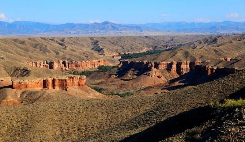
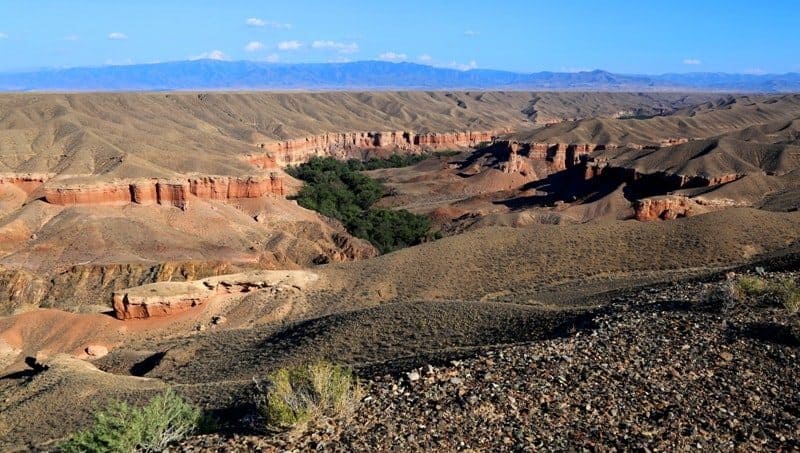
Temirlik River Canyon (Kazakh - Iron) is located on right bank of Charyn River, 4.3 kilometers east of Bestamak Canyon, west of Donkara valley in Uyghur and Raiymbek districts of Almaty region.
Temirlik River and canyons are located 181 kilometers (as the crow flies) from Almaty. The Temirlik Canyon is 25 kilometers long, with its mouth at an elevation of 865.8 meters above sea level where it joins the right-bank portion of the Charyn Canyon.
Temirlik River is the last major tributary of the Charyn. The foothill plain of the northern slopes of the Kuluk-Tau Mountains and the Ketmen and Shoshanai ranges is composed of red clay deposits mixed with rubble and rock remnants exposed by the Temirlik River.
Temirlik Canyon - Red Labyrinth of Sarykamys Valley.
Geomorphology and Natural Features of Temirlik Canyon.
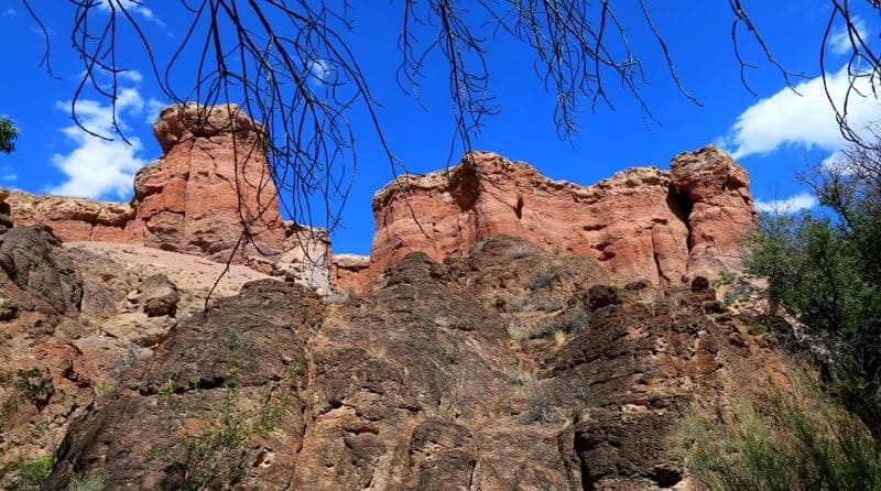
Temirlik Canyon is a system of deep, winding gorges cutting through thick layers of ancient sedimentary rocks. The dominant colors here are red, brown-orange, and ocher sandstones, which formed millions of years ago during the Mesozoic Era.
Under the influence of wind and water, the soft rocks have taken on fantastic shapes: towers, arches, columns, and fortress walls, leading locals to sometimes call this place the "Small City of Spirits." In many areas, the canyon is no more than 20 - 30 meters wide, while its walls reach 40 - 60 meters in height.
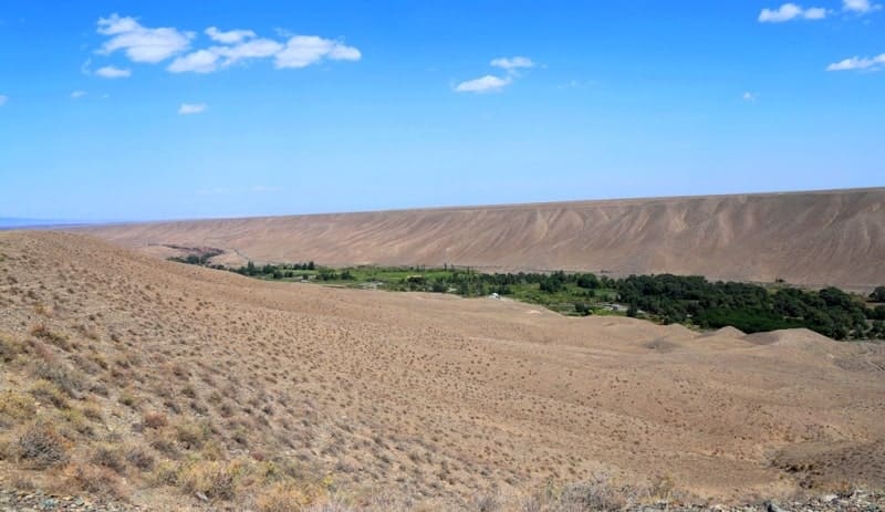
In the lower reaches, the gorge gradually widens, and green oases appear along the riverbanks: poplars, relict ash, willows, and dzhida provide shade and coolness in the summer heat.
Hydrology and microclimate of Temirlik Canyon.
Temirlik River becomes shallow in some sections during the summer, but in the spring and after rains, its current becomes rapid, creating small waterfalls and clear pools. The canyon's microclimate differs significantly from the surrounding semi-desert: it is cooler, more humid, and the wind is barely noticeable.
Historical and natural significance of Temirlik Canyon.
The lower part of the Temirlik Canyon is part of the Charyn National Park and is one of its most picturesque and inaccessible areas. Due to its isolation, relict flora species have been preserved here - shrub formations with elements of ancient Turanian vegetation and fauna.
Legend of Temirlik.
According to an ancient legend, a blacksmith named Temir (meaning "iron" in Kazakh) once roamed these mountains. He possessed a rare gift: he could forge blades that glowed in the dark.
After his death, the mountains seemed to absorb the power of fire and iron, and the cliffs turned a reddish-iron color. Since then, the gorge has been called Temirlik - "the place where the spirit of iron lives."
Modern significance and tourism of Temirlik Canyon.
Temirlik Canyon is one of the most spectacular routes in the eastern part of Charyn National Park. It is less well-known than the famous "Valley of Castles," but is equally beautiful. Jeep tours and hiking trails run here. The canyon is especially beautiful in autumn and at sunset, when the cliffs glow with shades of copper and gold.
Temirlik canyon is divided into three significant parts.
First Temirlik canyon.
The first, narrowest part of the canyon, 3 kilometers long, starts from the mouth of the Temirlik River. At the mouth, the width of the canyon reaches 270 meters, in the middle part - 390 meters, at the end - 420 meters. Water, over millions of years, has cut a deep and narrow canyon in the sedimentary rocks.
Forms of the resulting relief resemble the Valley of Castles in the Toraygyr mountains on the left bank of the Charyn River. You can get into the canyon both from the left side of the canyon and from the right. In order to get into the canyon from the left side, you need to turn off the road in the village of Aksai and move north along the dirt road, following the right branches of the roads.
You can go down to the canyon on a bad dirt road. The lowest part of the canyon can also be reached from the right bank. To do this, it is necessary to cross the Temirlik River to the right bank along the P-24 road and climb along the road to the exit from the canyon.
After leaving the canyon, you should immediately turn left and move along the dirt road for 8 kilometers. From this place you can walk down into the canyon.
Second Temirlik canyon.
Starting from the ancient necropolis of Sharbakty located on the right side of the canyon, at an altitude of 1076.3 meters above sea level, the Temirlik canyon begins to expand and stretches for 10.5 kilometers. The end of the wide part of the canyon ends in the vicinity of the Akmola necropolis.
The necropolis is located on the left side of the canyon, at an altitude of 1350 meters above sea level, in close proximity to the triangular road fork Chundzha - Kegen - Almaty. At the beginning of the wide part, the width of the canyon reaches 320 meters, in the middle part in the Sarykamys valley, the width reaches 2 kilometers, at the end of the second part of the canyon, the width reaches 1600 meters.
You can get to the Second Temirlik Canyon from the road bridge across the river, in the Sarykamys valley. The water of the river smoothly carries its waters under the canopy of numerous trees and bushes of red barberry along picturesque green glades.
A real oasis in the hot semi-desert. A huge advantage of this part of the canyon is the presence of a dense green thicket and thickets of turanga, which create a comfortable microclimate at the bottom of the canyon.
Third Temirlik canyon.
The third part starts from the Akmola necropolis and stretches for 8 kilometers to the left tributary of the Katuldruk. In the lower part, the width of the canyon reaches 370 meters, in the middle part up to 380 meters, in the upper part up to 130 meters.
The river in the shade of trees quickly carries water through a small rocky canyon and again goes out into the open spaces of a wide canyon.
Geographical coordinates of Temirlik canyon: N43°21'35 E79°09'53

Authority and photos by:
Alexander Petrov.