Вы здесь
Saur-Tarbagatai mountains.


In the Saur-Tarbagatai mountains Tours.
"The midday flame is dry and clear,
The crystal of the foothills is so beautiful
So pale gave gray mountains!
Salty wind curls in fingers ... "
Maximilian Voloshin. October 16, 1916.
The Great Silk Road and Saur-Tarbagatai mountains.
Geographical position Saur-Tarbagatai mountains.
Saur-Tarbagatay is located in the east of Saryarka. To the north of it lies the Zaysan depression, to the south - Alakol. Close to Lake Zaysan, the Saur Mountains, starting in China, on the western side of Ulyungir Lake, stretch from east to west between deep, large hollows.
The southern side of the hollows is the Konyr Mountains (in China). The basins were formed as a result of tectonic movements of the earth's crust. Tarbagatai in the form of several low mountains is located next to the Saur ridge.
They are separated by the Kandysu and Upper Emel rivers (in China). The length of Saura is 110 km. In Kazakhstan there is only its relatively short northern part 60 – 65 km long. Saur is connected to the Manyrak mountain range.
The northern foot of Saura abuts against Zaysan Lake and Cherny Irtysh, and the southern one borders on the Shilikty Basin. Tarbagatay is located in the west of Saura and connects with the Chingiztau ridge (250 km). It is lower, but longer than Saura (300 km). Its width is 30 - 50 km.
Relief and geological structure, minerals. The highest point of the mountain system Saur-Tarba¬gatay is located in Saur - Muztau peak (3816 m). The northern slope of Saura is similar in geological structure to the Altai Mountains, and the southern slope is steep and rocky with the Central Asian mountains.
he western part of Tarbagatai (from the Khabar Asu pass to the Ayaguz river), as well as the northern slope of its eastern part, enter the territory of Kazakhstan. The southern slope of the eastern half of Asu remains on the Chinese side.
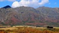
Tarbagatai is not very high. Its average height above sea level 2000 - 2200 meters. The highest point - Tastau - reaches 2992 m. The structure of Tarbagatai is composed of folded blocks. The tops of the mountains are very flattened.
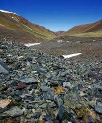
They are characterized by aligned flat areas. The slopes of the mountains are weakly dissected by gorges. There are no glaciers. Saur-Tarbagatay is mainly composed of Paleozoic rocks (clay and crystalline schists, sandstone, limestone and conglomerate).
In Saur, effusive rocks are widely distributed, which are represented by porphyries and porphyrites. And in Tarbagatai there are often limestone, many granites that are absent on Saur. Saur-Tarbagatay is a folded mountainous country. Its tectonic structure is formed in the Late Paleozoic during the passage of the Hercynian folding.
During alpine mountain building, Saur-Tar ¬ bagatai was updated. The formation of the modern relief was influenced by ancient glaciations, erosive effects of flowing waters and new tectonic processes. So, in 1990 there was a strong earthquake in Zaysan, which caused significant material damage.
The Kendirlik coal deposit is located in Saur. Oil reservoirs are explored. Large stocks of oil shale were found.
Climate and rivers in Saur-Tarbagatai mountains.
The climate of the Kazakh part of Saur-Tarbagatai is continental, similar to the climate of Southern Altai. The difference is that compared with Altai there is less rainfall. According to its natural features and climate, it is a transition zone between the mountains of Southern Siberia and Central Asia.
In January, the average air temperature is 20 ° С, in July + 22 ° С. The average annual precipitation is 350 - 500 mm. In the mountains, the higher the greater the moisture and the lower the temperature. The snow line in Saur is located at an altitude of 3300 m.
Therefore, its peaks are constantly covered with snow. In the mountains of Muztau there are glaciers (the largest 4 - 5 km2). It is usually dry and hot in the plain. There are no glaciers in Tarbagatai. The rivers are small, many begin in the mountains.
The rivers - Zharma, Kayyndyssu, Kokpekty - once flowed into Zaysan, now they do not reach the lake. The mountain rivers Karabulak, Zhetyaral, Karabug, Bazar dry up when they enter the plain. The rivers Urjar, Khatinsu, Emel, flowing down from the southern slope of Tarbagatai, flow into Lake Alakol, the Ayaguz River into Balkhash.
The ridges are composed of strongly dislocated Paleozoic sedimentary rocks (schists, limestones, sandstones), broken by acidic intrusions (granites, etc.). On Saur there are deposits of coal (Kendyrlik) and oil shale. The slopes of the ridges are deeply divided by gorgeous valleys.
At Tarbagatai, the northern slope is more south, the ridge is flattened; the watershed is pressed against the steep southern slope of the ridge; in Paleozoic limestones on the ridge, karst phenomena are developed. The lower parts of the slopes of both ranges are occupied by semi-desert and higher steppe vegetation.
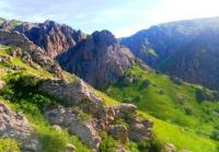
On the northern slope of Saura, mid-mountain meadows and forests from Siberian larch (Larix sibirica) and Tien Shan spruce are widespread. Siberian fir occurs as an impurity in spruce forests. In the river valleys, forests rise to a height of about 2600 m.
In Tarbagatai, woody vegetation is found only in river valleys, and thickets of wild apple trees are characteristic of the valley of the southern slope. Outside the valleys on the southern slope, shrubs from rose hips are widely developed.
Western Tarbagatai in eastern direction as though continues Saryarka massif - Chungiztau. Geological history of Western Tarbagatai is similar to history of Chingiztau. Both ranges are caledonides, formed during early Paleozoic period. Eastern Tarbagatai is younger, it as well as Saur are related to hercinides (late Paleozoic period).
Tarbagatai is separated from Saur by boggy Chiliktinsky (Shuluktinsky) valley.
Natural areas of Saur and Tarbagatai. Flora and fauna of Saur and Tarbagatai.
Saur in Kazakh has the meaning of "croup". It is explained by that fact that the hills look like roof uplift. Length of the ridge is about 130 kilometers and maximal width is 60 kilometers. The highest top Muztau (Ice Mountain) is in territory of China. Its height is 3816 meters.
In the west Saur comes to Manrak low ridge (2053 m) which ends in 20 kilometers from Zaisan Lake coast. Modern icing is rather developed in Saur. Fifty years ago only within Kazakhstan part of Saur there were 18 glaciers which occupied the area about 16,6 square kilometers.
The biggest glacier stretched in length for 4 kilometers. Present condition of glaciers of western part of Saur is unknown: there are no available data. It is possible to suppose that glaciers were considerably reduced for the last half a century. A little bit larger icing area is in Chinese part of Saur.
Permafrost in these places is extended above 2200-2300 meters. It is surprising that there are no rock glaciers in Saur, but icing and other cryogenic forms of relief are common occurrence in these mountains. Woods grow in deep gorges of Saur.
Here a place of meeting of Siberian and Central Asian coniferous trees -larch and Tien-Shan firs. Sometimes you can meet Siberian silver fir. In shaded and humidified gorges the trees can be met at big height up to 2600 meters.
In high mountains on flattened watersheds between the gorges Alpine meadows are widely spread, in some cases it is possible to see golets - rock placers with poor vegetation. Golets are typical landscapes of the mountains of Siberia. Higher there are glaciers, snowfelds, rocks and taluses.
There are no large deposits of minerals in Saur-Torbagatai. Only in northern foothills of Saur and Manrak there is Kenderlyksky brown coal fields. Saur till now remains poorly investigated and the least explored mountain territory.
Authority:
“Central Asia Mountains”. 2009, Almaty,Publishing house “Mektep”. Authos Aldar Gorbunov, Anna Ivachenko, Sharipa Bisarieva.
Photos
Alexander Petrv.


