


![]()
Вы здесь
History of town Aulie-Ata.

Cultural Tours in Taraz.
“From the top of the Tek-Turmas hillock, the city and its environs were clearly visible. On a high hill, the Kokand fortress with a citadel turned yellow. Down to the south were residential squares hidden by greenery. The territory of the city was stretched along the river. Talas, just like the fortress, was defended: from the east, by a natural steep bank of the river, from the south by a double row of defensive walls, in front of which there was a marshy, indented lowland with irrigation ditches. From the south-west, the city was covered by a segment of the wall with two protruding towers, from the west by an unfinished duval, wattle, and serifs. The area here was hilly, overgrown with gardens and trees”
Walking tour in Taraz.
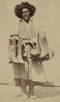
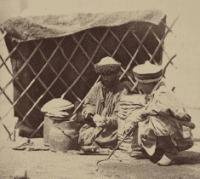
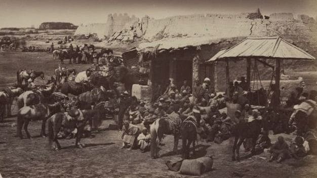
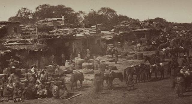
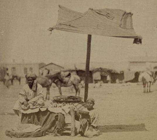
Old photos - ajar window to the past. They are always touching, because what is captured on them has long sunk into oblivion. Aulie-Ata photographs evoke a special tremulous feeling, since we have before us the priceless chronicle of the true history of our native land.
The first photographs of the Aulie-Ata fortress were printed in Turkestan Album, a unique album created by order of the first governor general of Turkestan, Konstantin Petrovich Von Kaufman. The Turkestan Album includes four parts: archaeological (two volumes), ethnographic (two volumes), crafts of the peoples of Central Asia (commercial) and the historical part.
The albums were created under the leadership of the Russian ethnographer and researcher A.L. Kuna. In addition to the albums worked: military orientalist T.A. Terentiev, photographers N.N. Nekhoroshev, G. E. Krivtsov, and other photographers, capturing the views of streets, bazaars and squares of cities, villages and nomads; in portraits - faces, types of Central Asian nationalities; festivities, customs and traditions and much more.
Thus, this photo album gathered documentary evidence of the then unexplored region of Central Asia (the second half of the 19th century), in order to characterize the everyday life of the settled and nomadic population of the Turkestan Territory.
The collection of materials for a multi-volume publication for more than two years (1870-1872) was carried out in the military topographic department of Tashkent. The album was released in St. Petersburg in 1872. The Turkestan Album is today the rarest archival source, whose editions are in the National Library of Uzbekistan, the National Library of Russia and the Library of Congress. Moreover, all the pictures have already been posted on the Internet for free access with saving records of that time.
Photos of the city of Aulie-Ata from the Turkestan Album, 1871 - 1872. The history of the city of Taraz dates back more than 2 millennia and includes the heyday of settled civilization, when Taraz was the metropolitan, commercial and cultural center of the early medieval Turkic states.
However, the heyday was replaced by a period of war and strife, then the city was practically subjected to destruction and ruin. However, the ancient city was not wiped off the face of the earth, the ruins formed a high hill on which at the beginning of the XIXth century a new city began to revive, but under the new name “Aulie-Ata” - (Holy Elder), as a tribute to the preserved monument - the mausoleum Karahan. Favorable location on trade roads and favorable natural conditions began to attract a settled population.
So, with each new era, the center of the Talas Valley - the ancient city of Taraz was reborn from the ashes again, continuing the centuries-old chronicle of the glorious city. The small evidence of the settlement of small plots on the ruins of some medieval hillforts of the Talas and Chui valleys speak only of the small remaining centers of settledness during this period in the South-Western Semirechye.
In 1815 - 1864 Talas valley and the adjacent land were under the rule of the Kokand Khanate. In 1821 - 1827 on the ruins of the medieval settlement of Taraz, the Kokandans built a fortress, which entered the northern branch of the Kokand fortifications.
Clay for construction was taken at the ancient settlement, as a result, its upper archaeological layers were disturbed and the original appearance was changed. What was the Kokand fortress? Where was it located and what role did it play in the history of our city?
Rare chronicles and photographs of the XIXth century, records of military and civilians who visited the region after the accession of South Kazakhstan to the Russian Empire can give objective answers to these and other questions. Let us turn to the primary sources to find out how the urban development of our city began.
The first explorers of the Aulie-Ata fortress were the military of the Zachuisky detachment under the command of Colonel M.G. Chernyaev, formed to liberate the Chu-Talas Valley from the Kokandans. Here is a sight on the banks of the Talas appeared before the detachment of M. G. Chernyaev:
“From the top of the Tek-Turmas hillock, the city and its environs were clearly visible. On a high hill, the Kokand fortress with a citadel turned yellow. Down to the south were residential squares hidden by greenery. The territory of the city was stretched along the river.
Talas, just like the fortress, was defended: from the east, by a natural steep bank of the river, from the south by a double row of defensive walls, in front of which there was a marshy, indented lowland with irrigation ditches. From the south-west, the city was covered by a segment of the wall with two protruding towers, from the west by an unfinished duval, wattle, and serifs.
The area here was hilly, overgrown with gardens and trees. It was fashionable to enter the city through double gates from the south, flanked by rounded towers. Outside the city, to the west, on a hill there was a vast cemetery, and the mausoleum of Karakhan was visible.
There was a tugai around the cemetery, covered with reeds and a talnik.” At that time, the Aulie-Ata fortress was the largest among the Kokand fortresses in the south of Kazakhstan, representing a typical example of the Kokand fortification.
According to the collected military data, Auliye-Atu could be called a fortification-city and even commercial: it was one of the main Kokand fortresses in Semirechye, even surpassing all other fortresses in size. There was a large bazaar and up to 1,500 inhabitants.
The fortress was surrounded by a moat and rampart, had 5 copper cannons and a garrison of dzhigits of 100 people and sarbazes of up to 500 people. In 1859 - 1860 in the arsenal of the fortress there were 8 cannons and several dozen large guns firing buckshot. In the field, they drove in camels.
Lying at the foot of the mountains, in the Talas valley, Aulie-Ata served the Kokandans as an important stronghold in the valley of the river. Chu, as well as a warehouse for military and food supplies. From here, provisions and other goods were delivered to Pishpek and other nearby fortifications.
It was a collection point of all troops sent to the Syr Darya valley, for the protection of the upper reaches of the river. Chew. Then, at the beginning of June 1864, after the unsuccessful diplomatic negotiations of M. G. Chernyaev with the Kokand Bek Parvanachi Niyaz-Ali, the Zulu detachment Aulie-Ata fortress was taken by storm, this event predetermined a new course of history for the entire region. Following Auliye-Ata, Chernyaev occupied the Kokand fortification of Chimkent, and the detachment of General Verevkin - Turkestan.
As a result of this military company, 1863 - 1864. southern lands of Kazakhstan were annexed to the Russian Empire. Immediately after the assault, Chernyaev wrote a note about the Auliye-Ata fortress, which contains rich historical material on the stratigraphy of the fortress, the number and composition of the inhabitants, the material and spiritual life of the city residents are given here.
So, this historical document is a unique local history source. I will give the full content of this document, stored in the central state archive of Uzbekistan. Among the first researchers in the history of the fortress was V.A. Kallaur, a district chief and passionate local historian who made a huge contribution to the study of the history of the region and the formation of the city of Aulie-Ata.
Based on many years of local history research, V. A. Kallaur in 1903 at a meeting of the Turkestan circle of archeology lovers (TCLA) cites an article “On the history of the city of Aulie-Ata”, which sets out in detail the messages of the city’s old-timers:
“At first, upon arrival when serving in Aulieat, in 1876, I have heard more than once from local natives that the present city of Aulieata was founded recently, that old-timers still live, who were one of the first to live in it, who remember well how the mound (fortification) and the bazaar were built and urban settlement, surrounded by a mud wall, the remains of which have been preserved along Karasu from Tikturmas (Talas) to the present, and that before the construction of the mound in Aulieat, the settled settlement was in Uch-mound, where the bek with Sinai (police guard) had lived before, which later transferred to again built mound to Aulieata."
Vasily Andreevich in the winter of 1897 - 1898 conducted a survey of local residents who told him historical data on the history of the formation and settlement of the city. He talked with the honorary resident of the city - Kshchrali Nurakov, a Karakirgiz, of the Alakchin clan (he died in the winter from 1898 to 1899), 63 years old, the former ruler of the Uch-Kurgan volost.
“The old man said that his father and grandfather ruled the Karakirgiz people during the Kokand rule, and he himself was a beiy as appointed by the Kokand khan. In the Aulieatinsky district in the old days there were no settled settlements; in Kokand, the time was primarily built, under his father Nuraka, the mound (fortress) of Yana-mound, and a small settled settlement was established here. At that time, there was a bek with police guards in Yana Kurgan.”
Kallaur localized the location of the Yana-Kurgan fortress - “now this place is called Uch-Kurgan (Uch-Kurgan is located on the left bank of the Talas river above Aulieat 18 miles on the road to the mountain valley of the Talas river, now this place is on the territory of Kyrgyzstan, K. BUT.)".
Further, the old man said, “After some time, the mound (fortification) of Aulieat was built, where, leaving Yany-mound, the Yany-Kurgan bek with dzhigits crossed. After this, the Sarts also began to gradually leave the Yana Kurgan and move to Aulieat.
When a settled settlement was established near Aulieat mound, then the Bek Magzum-Kashgar built a bazaar, 6-8 years before the Russians occupied this city. ” “Thus, Kallaur makes a conclusion according to the calculation of Nurakov that the city of Aulieat exists for 71 years (since 1827), and 6 years before that the Yany Kurgan (Uch-Kurgan) was built” 5.
V.A. Kalaur found another witness, an elderly woman, Parna Isengeldin, who at that time was 96 years old. Despite her advanced age, she provided interesting data on the structure of the city: “... Her father, the Kyrgyz Isengeldy Kenjebaev (the Isengelds came from the Kyrgyz Kazakhs, the clan Ramadan, who lived in the Tashkent district, had the rank of Balyrbashi, additional Kallaur) served as a darcharkhan for Yana -Kurgan (Uch-Kurgan) Bek Kurban-Muhammedov, who built the mound of Yana-Mound by the labor of the people, by order of the Tashkent hakim Rajab Bekderbegi, where Uch-Kurgan is now.
After 6 years, Adinabek built the Aulneat mound on the site where there was previously a hill (bulk mound), and moved there from Yana-mound. That was 71 years ago. The people settled near the mound along the old Namangan-Koche Street (Namangan Street), about 60 years ago.
Subsequently, a bazaar was opened there. The transition from the Yana Kurgan to Aulieat Bek was caused by the unrest that occurred there and the inconvenience of collecting zyaket. Before Rajab Beklerbegi, the Kirghiz and Karakirgiz along the Talasu River were independent and independent people; under him, their submission to the Kokand Khan took place.
When the city of Aulieat began to be populated, then in the vicinity of the grave of St. Aulieat there was a tugai covered with reeds and a talnik. Tugay separated Namangan Koche from the grave of Aulieat. There were no settled inhabitants at all.
Another old-timer, Bekmurza-aga Khudaykulov, a native of Karamurt village of the Chimkent district, who is 104 years old, Kallauru made the following message: “According to his calculation, the city of Aulieat has existed for no more than 70 years.
Previously, the inhabitants of the city lived in Yany-Kurgan (now Uch-Kurgan); but there the nomads of the Karakirgiz did not give rest, and therefore, by order of the Tashkent hakim Rajab - Kushbegi * (died in 1820, V. Nalivkin, the source of the Kokand Khanate, pp. 114 - 115), the Aulieat mound was built, where residents from Yana moved -Murgan.
The builder of Aulieat mound was Ruzymat, and the workers were Kyrgyz from the vicinity of Aulieat. Clay was kneaded by horses, for which many shoals were driven ”5. So, based on the above messages, the old-timer of the city of Kallaur made very accurate calculations, confirmed by historical data, that in 1826 or 1827 the mound (fortress) of Aulieat was built.
Since 1837, a settled settlement, known as Namangan-Koche, began to appear next to the Aulieat burial mound, and since 1856, with the construction of the bazaar, the modern city of Aulieat appeared. 5 Also, this fact of the formation of the city is confirmed by the message of S. I. Malitsky 6 ".
Mirza Akhmet Parvancha, to whom the city of Aulieat was subordinate and by order of which a bazaar was established in Aulieat, which laid the foundation for the city, was a Tashkent khan from 1853 to 1858." Even then, Kallaur made the assumption that the Aulieat mound was built on the ruins of an ancient fortification, which, judging by the finds and the size of the hill, could be ancient Taraz! So to say, he hit the nail on the head, having no historical or archaeological education.
Conclusion.
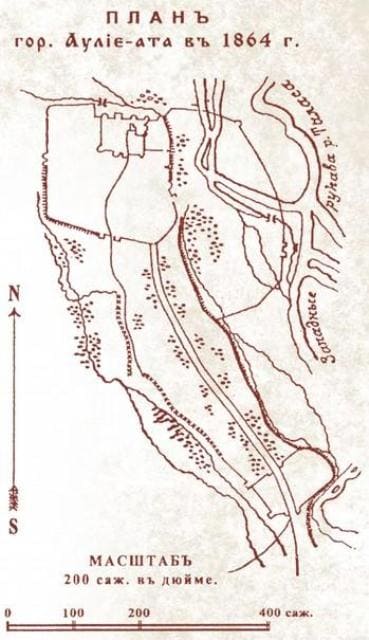
Thanks to the above written sources and archaeological data, today you can accurately localize the location of the Aulie-Ata fortress, however, the traces of the ruins of the fortress, unfortunately, were destroyed in the mid-50s and early 60s.
The twentieth century when working on the improvement of the city market and the construction of houses in the adjacent territory. So, what about the past history today can be judged either by archival materials, or by archaeological research.
So, on the basis of many years of research, the location of the Aulie-Ata fortress in relation to the modern streets of the city8 is localized: “The defensive walls of the Aulie-Ata fortress coincided with the ramparts of the ancient settlement, with the exception of the western and southern sides. In plan view, the fortress was an irregular rectangle (360 × 390 m), on three sides, with the exception of the south, surrounded by a moat. From the moat there remained the Tuite canal, flowing now west of the former central market.
The outer walls of the fortress passed along the modern streets of Mirzoyan, Kylyshbay akyn, Kazybek bi and Tole bi. The fortress had eastern, western and southern gates. The gates were flanked by round-shaped towers, the thickness of the walls at the base reached 2 m.
The citadel (sides 162, 117, 147 and 123 m long) was inside the fortress, forming a second fortification wall on the north side. The walls, built of adobe bricks and pakhovy blocks, were 4 m wide at the base. The towers and walls had a toothed finish, traditional for Kokand fortifications. B
etween the citadel and the eastern wall of Shahristan there were garrison buildings; in the southeastern part there are trading districts and residential houses of artisans. The construction of Aulie-Ata of the Kokand period did not differ much from other Central Asian cities - narrow curved streets, mud-brick houses with windows to the courtyard, lack of greenery on the streets.
To ser. XIX century the city had 2 - 3 thousand inhabitants and occupied the territory within the current 2nd Uzbek lane, Kanavsky passage, Proletarskaya and Rodnikova streets.” The modern city, unfortunately, did not preserve the fortress itself, but the layout of the first streets was based on the directions of the old caravan roads along which settled nomads and immigrants settled, so that every street, every district of the city bears a historical imprint of the time when it became build up and populate.
So, in the town of Taraz there are many more interesting pages of history captured in the development and layout of the modern city. Krokosheva A.V. Researcher GIKZM "Monuments of ancient Taraz".
Authority:
Taken Moldakynov, Director of the State Historical and Cultural Reserve Museum "Monuments of ancient Taraz." http://www.drevniytaraz.kz
Literature:
1. The set of historical and cultural monuments of the Republic of Kazakhstan. Zhambyl region, -Almaty: RSE "NIPI PMK", -T. 2. 2002.- 62 s.
2. F.P. Grigoriev. Aulie-Ata in 1864-1917.//- Tuғan өlke. No. 1 (6) 2006.
3. Maksheev A. Historical review of Turkestan and the Russian offensive movement in it. SPb., 1890. P.220
4. TsGA of the Uzbek SSR, Fund No. 4-715 OP No. 1 D. No. 27 L. No. 218-224
5. Kallaur V. A. To the history of the city of Aulie-ata // PTKLA. Tashkent, 1903.
6. S. I. Malitsky. “On the history of the city of Tashkent” // App. to PTKLA, Tashkent, 1900.
7. Maksheev A. Historical review of Turkestan and the Russian offensive movement in it. SPb., 1890. drawing 2.
8. The set of historical and cultural monuments of the Republic of Kazakhstan. Zhambyl region, -Almaty: RSE "NIPI PMK", -T. 2. 2002.- 63 s.
Photos:
Photos used from Turkestan Album, 1870-1872. Created by order of the first governor general of Turkestan, Konstantin Petrovich Von Kaufman. The Turkestan Album includes four parts: archaeological (two volumes), ethnographic (two volumes), crafts of the peoples of Central Asia (commercial) and the historical part. The albums were created under the leadership of the Russian ethnographer and researcher A.L. Kuna. In addition to the albums worked: military orientalist T.A. Terentiev, photographers N.N. Nekhoroshev, G. E. Krivtsov, and other photographers, capturing the views of streets, bazaars and squares of cities, villages and nomads; in portraits - faces, types of Central Asian nationalities; festivities, customs and traditions and much more. Thus, this photo album gathered documentary evidence of the then unexplored region of Central Asia (the second half of the 19th century), in order to characterize the everyday life of the settled and nomadic population of the Turkestan Territory. The collection of materials for a multi-volume publication for more than two years (1870 - 1872) was carried out in the military topographic department of Tashkent. The album was released in St. Petersburg in 1872. The Turkestan Album is today the rarest archival source, whose editions are in the National Library of Uzbekistan, the National Library of Russia and the Library of Congress.