


![]()
Вы здесь
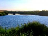
River Torgay.
Guide to the Aktobe region.
“August must be shed slowly, like pear liquor. Pour into a small glass, drink a drop, and look through the glass at the sun. August nights should be diluted with candle lights, milk poured into a cup for a brownie, purring a cat and the chatter of grasshoppers. August days should be laid between the pages of books, like bookmarks, in order to then shake out their heat in the dank November of taking this book from the shelf. And I conjure you, well, do not shout at all corners, "Oh, here is August, here is autumn"
Ray Bradbury.
Hiking routes in the Aktobe region.
The Torgay River is formed outside the region from the confluence of the Zholdama and Karatorgay, then takes a series of tributaries, and flowing through the Aktobe region through a series of lakes is lost in the closed cavity of the Shelkarteniz.
The length of the river is 825 kilometers, area basin 56.5 thousand square kilometers It flows mainly along the Turgai hollow, breaking into wide floodplain on the sleeves, forming many lakes and old rivers. Food mainly snowy. It freezes in the first half of November, opens in the first half of April.
The riverbed is winding, the width is mainly 20 - 40 m, in places it can reach up to 60 m. Clay bottom. The flow velocity is 0.1 m / s, in places the water is almost stagnant. There are few fords. In the river valley there are many old women and lakes. In floods, the depth of the river is 1 - 4 m, flow velocity 0.2 m / s.
The river and lakes freeze in mid-November, open in early April, ice thickness - 1 m. Water level in Torgay and other large rivers rises during the spillat 4 - 5 m, water fills the low places of the valley, fills the dry old women, lakes and ducts.
By the end of April, rivers flow in their channels, but fords through Torgay can be Drive only from the beginning of June. The annual flow of the Torgay river basin is formed mainly during the spring floods. During the period from April to May, up to 90% of the annual flow passes along the river.
Mineralization of water during the spring flood in the upper reaches 0.2 - 0.3 g / l, in an average course of more than 0.5 g / l. The composition of the water is hydrocarbonate calcium-sodium. The water is moderately hard, good, drinking.
During the summer low water season, mineralization in the upper reaches increases to 0.6 - 0.8 g / l, and in the middle course in individual reaches up to 20 g / l, the composition of the water varies to sodium sulfate and chloride.
Authority:
Natural resources of Aktobe region. Ecoproject LLP. 216 p.
Photos
Alexander Petrov.