


![]()
Вы здесь
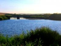
River Olkeyek.
Excursion bus tours in Kazakhstan.
“A person has enough objective reasons necessary for the desire to preserve wildlife. But, ultimately, he can save nature only with his love for her. Since a person in this world cannot live without beauty, if only he loves and appreciates the environment a little, nature will be able to get rid of the danger that threatens her”
Jean Dorst.
Hiking routes in Ustyurt.
The Aral Sea basin includes the Torgay River with its tributaries Olkeyek, Kyrgyzstan, Telkara and many temporary streams. The hydrological regime of rivers in the summer-autumn and winter periods is characterized by low water availability - many rivers dry up in the summer and freeze in the winter.
Main phase the water regime of the rivers is spring flood, which accounts for most annual runoff. The amount of spring runoff depends on the water reserves in the snow before the beginning of melting, precipitation during the flood period, the degree of soil moisture and depth freezing, snowmelt intensity.
According to the long-term average data, the river opening is observed at the end of March - the first half of April. Opening of rivers is usually accompanied by ice drift (1 - 3 days). The rise of spring flood levels is intense.
Within 3 - 10 days the water level reaches its highest height and lasts no more than 3 days, then an intensive decline begins within 4 to 12 days. In early May, steady low water. The Olkeyek River (Ulkayak) is formed from the confluence of the Basilbeksyay and Otyzbaysay rivers (Kostanay region), flows into the Torgay river, passing through many lakes.
River length 349 km, within the region 114 km, catchment area 13,300 square kilometers. The width of the river is up to 35 - 40 m, sometimes less than 10 m, the depth is 1.3 - 2.3 m, the flow velocity is 0.1 m / s. Bottom predominantly silty, gentle banks, steep in some areas.
River lost in lakes in the valley of the Torgay river. The water in Olkiejek is fresh. After the spring flood (in May-June), the flow in the river almost stops. River It is divided into a number of stretches, alternating with dry rifts.
Winter thicknessice in the reaches reaches 1 m, and the shallowest of them freeze. In individual In places, the channel is completely covered with snow. In spring, water in a river of chloride composition with mineralization of 0.4 - 0.8 g / l, moderately hard, good in drinking qualities or satisfactory. In summer, the reaches of the waters are highly mineralized, very hard.
It can be used for drinking in extreme cases, and in some reaches unsuitable for cattle watering. For household and drinking supplyWells 10-12 m deep were built on the banks of the river. 6 dams were built on the river.
Authority:
Natural resources of Aktobe region. Ecoproject LLP. 216 p.
Photos
Alexander Petrov.