Вы здесь
Martuk Nature Reserve.


Tours 2026 in Kazakhstan.
“Nature searches us at the exit, as at the entrance. You can't bear more than you brought.”
L.A. Seneca.
Bicycle tours in Kazakhstan.
The Martuk State Nature Reserve is located in the Mortyksky district of the Aktobe region. The motives for organizing the Kobdinsky integrated nature reserve were the preservation of natural complexes and reference areas of vegetation characteristic of the steppe zone.
Protection of unique landscapes of forest trunks of black alder, birch, oak, pine; Red Book species of flora and fauna, habitats of moose, roe deer, wild boars, beavers, marmots, waterfowl and near-water birds. Here is the only place where the relict of the Tertiary time - the female coder - is growing.
Most of the territory is represented by a hilly-steep plain with absolute marks 300 - 400 m. The elevated part of the plain, divided by a complex branching river network, is sometimes complicated by low hills of various shapes.
The average relative elevations within the watersheds range from 20 to 35 m, the absolute marks of the watersheds from 200 to 360 m. The eastern part is more elevated and is cut by valleys of tributaries of the Kiyaly-Burtia River.
Low hills and ridges have smooth shapes. And only rivers and temporary streams in their valleys form erosion ledges from 2 to 6 m high. The climate is sharply continental: the average January temperature is -17 - 19 ° C, July +20 + 21 ° C, the average annual air temperature is +1 + 2 ° C.
The sum of temperatures above 10 ° C is 2200 - 2500 °, the amount of precipitation is 280 - 300 mm, the duration of the frost-free period is 130 - 150 days, the hydrothermal coefficient is 0.8 - 1.0. Coefficient of humidification - 0.40 - 0.50.
The average annual wind speed is 4.5 - 5.5 seconds, north-west winds prevail. Surface water is represented by the left tributaries of the Zhayyk - Kiyaly-Burtia river (with tributaries Kuchukbay, Abdan, Tarangul, Zhosasay, Ungir) and Burtia (with tributaries Karagashka-1, Karagashka-2, Tarangul) and small temporary streams originating from numerous springs.
The water in the rivers during the year is fresh, with a hydrocarbon-calcium composition. Rivers insignificant, have a width of 3 - 20 m, a depth of 1 - 2 m. The flow velocity does not exceed 2 m / s. The floodplains are not wide, open, overgrown with woody-shrubby and meadow vegetation.
The banks are usually low-lying, but sometimes steep, up to 2–6 m, rarely up to 10 m. Most of the shallow rivers and temporary streams are enclosed by dams that form reservoirs. Groundwater: confined to terrigenous and sulfate-terrigenous deposits of the Permian-Lower Triassic, represented by sandstones, siltstones, and gravelites.
Groundwater of pore-fissure and fissure-karst type. In places where they reach the day surface, they are pressureless, at the foot of ridges, on the slopes of river valleys and ravines, they form springs or open at a depth of 10 - 15 m in depressions to 100 - 140 m on the watershed.
Fresh and slightly brackish waters with a salinity of 0.2 - 2.5 g / l of predominantly sodium sulfate, less often sodium hydrocarbon composition are widespread. In the Upper Triassic-Jurassic rocks, represented by variegated sands with gravel and pebbles and weakly cemented sandstones, fresh and weakly brackish waters are formed with a salinity of 0.3 to 2 g / l of hydrocarbonate, sulfate sodium or calcium composition.
The soil cover is represented by zonal widespread chernozem soils: normal southern chernozems, underdeveloped and carbonate; homogeneous and leveled plots are almost completely developed for agriculture.
Less common are chernozems that are incompletely developed on hills and solonetzes, found along floodplain terraces of rivers. Solonetzic chernozems are spotted among ordinary chernozems or form complexes with solonetzes.
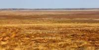
The vegetation cover is represented by red feather grass, mixed grass, mixed grass steppes with a predominance of feather grass. Fauna of the Martuk Wildlife Refuge. In the floodplains of the rivers, along the shores of lakes and in the valleys of temporary streams, lake and moor frogs are widespread.
Mammals are mainly represented by steppe species. Numerous rodents.
Authority:
Natural resources of Aktobe region. Ecoproject LLP. 216 p.
Photos by:
Alexander Petrov.


