Вы здесь
Akchakaya Depression.

Depressions and hollows of Turkmenistan.
“The deeper we get into the interconnectedness of phenomena, the sooner we are freed from the error that not all branches of natural science are equally important for the culture and welfare of peoples”
Great geographer Alexander Humboldt "Cosmos".
Sights Akchakaya hollow.
Akchakaya (Akhcha-Kaya) is a drainless hollow in the northwestern part of Karakum, in Turkmenistan. The length of the depression is about 50 kilometers, the width is about 6 kilometers, the relative depth is 200 meters, the bottom of the depression lies 81 meters below sea level (the second deepest after the Karagie depression in the CIS).
Curved in the shape of a horseshoe, has high steep sides. It was first studied in 1935 by Soviet geographer Eduard Makarovich Murzaev.
“The survey showed that its bottom is 81 meters below sea level. The cliff of the Ishek-Ankrenkyr plateau with beautiful steps by an amphitheater contours the hollow. Its width was six kilometers. This depth is second in the CIS.
Below the Akchakai Basin, there is only the Karagie Basin in Mangyshlak. Meanwhile, it was only recently believed that the lowest point in the CIS is the bottom of the Sarakamysh depression, which lies at minus 46 meters.
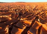
On the flat bottom of Akchakai one can see vast takyrs, puffy salt marshes, but it is dry everywhere; here, in the hollow, rivers do not flow, there are no streams, not even wells. In other climatic conditions, these hollows, of course, would be filled with water and here one could listen to the splashing of lake waves and watch the white lamb dropping breezes over the surface of the water.
Brightly colored rocks are exposed in the cliff of Akchakai. Green, white, red, pink clays, limestones, marls form well traceable ribbons. A geologist found shark teeth in the light clays of the lower horizon.”
Authority:
Alexander Petrov. "Years of searching in Asia." Murzaev Eduard Makarovich.
Photo
Alexander Petrov.


