


![]()
Вы здесь
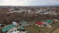
History village of Saumalkol.
A trip to the North Kazakhstan region.
“Hunger that will not make you eat. Satiety that does not force to tell!"
Turkmen proverb.
The history of the villages of the North Kazakhstan region.
The village of Saumalkol (Kazakh. Saumalkul) is the administrative center of the Ayyrtau district of the North Kazakhstan region. The administrative center of the Volodarsky rural district. The village is located on the shores of the lake of the same name, 248 kilometers southwest of the regional center - Petropavlovsk and 92 kilometers west of the nearest city - Kokshetau.
Previously, the village was called Krivoozernoye and was founded in 1866 by five families who voluntarily resettled from the Chelyabinsk district. It gained official status in 1884. In 1922 it was renamed Volodarsky in honor of the red commander Ivan Volodarsky, who fell at the hands of Kolchak’s soldiers in a battle for the village in November 1919.
On May 2, 1997 it was renamed to Saumalkol. Until 2013, part of the village was part of the now abolished Zhetykol rural district. In May 1854, a family of Chelyabinsk migrant peasants settled between birch pegs and on the southwestern shore of Lake Saumalkol, a little later Shchadrins moved to them, then Permians.
In 1878, Tobolsk peasants arrived in the village. A small village was formed. Starting a farm, the peasants did not know yet whether they would be allowed to settle here: they lived under fear and therefore built houses in haste: without courtyards and without roofs with ceilings covered with layers of earth.
The fertile lands on the western shore of the lake were used as arable land, which yielded crops for 6 years without vapors. The forest for the construction of houses was located 25 kilometers in Ayyrtau, but the peasants preferred to buy finished houses from the Cossacks and transport them to their village.
"A hut in two rooms is valued here from 50-60 rubles., In 1 room from 20 - 30 rubles." Founded in the midst of Kazakh nomads, the village grew rapidly due to migrant peasants and the Kazakh poor. The peasant settlement (from “settle”) receives official status and is renamed the village of Krivoozernoye and is endowed with land of 15 acres per male soul.
In 1887, there were already 224 yards in Krivoozernoye, and the population was 1716 inhabitants. The village has a church and a school. In 1891, the village became the center of the volost and is called Krivoozernoye.
This volost includes the villages of Orlovka, Galitsino, Kruglovka. The area of the volost amounted to 12837 acres, including 4195 acres of arable land. In 1919, Krivoozernoye was renamed into the village of Volodarskoye in honor of the commander of the Red Army platoon I. Volodarov, who died in the vicinity of the village in a battle with the White Guards.
In 1928, Volodarskoe became the administrative center of the Volodarsky district. In 1993, the village was renamed Saumalkol by the name of the lake, and the district was Ayyrtau. The boundaries of the district have changed several times.
In 1964, part of the lands of the district went to Ruzayevsky district. In 1966, part of the district’s territory went to Arykbalyksky district. In May 1997, the Aiyrtau and Arykbalyk districts merged.
Authority:
http://op-airtau.sko.kz
Photo
Alexander Petrov.