


![]()
Вы здесь
History of Astana.


History Kazakhstan and Silk Road.
"Inside every city there is always another city."
Gilles Deleuze.
Historical tourism in cities of Kazakhstan.
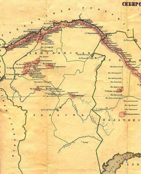
The history of the steppe Akmola military fortress, which later was to become a trade crossroads in the steppes of Saryarka, the center of the virgin land and the capital of Kazakhstan, began with the administrative imperial reform: in 1822, Alexander I adopted the Charter on the Siberian Kyrgyz.
The middle zhuz, traditionally nomadic in the territory of Akmola, was included in the newly formed Omsk region and divided into administrative districts and auls. In 1824, the first two district orders were opened - Kokchetavsky and Karkaraly.
Due to lack of financial resources, the opening of other external districts was postponed for some time. In 1829, Sultan Konyrkuldzha Kudaymendin, great-grandson of Semek Khan, ruler of the Middle Zhuz, turned to the Russian government with a request to protect his auls from raiding "robber gangs" and to form an order in the Karpikovskaya and Kuandykovsky volosts controlled by him.
Other sultans and tsarist officials have repeatedly applied for protection of trade caravans coming from Turkestan to border places and vice versa. On this issue, the administration of Western Siberia was contacted in 1829 by Sultan Gubaidulla Valiev, who headed the Kokchetav order.
Major General S. B. Bronevsky, chief of staff of the Separate Siberian Corps, also reported in Omsk in September 1829 that “in the Karpykovsky volost, led by Sultan Konurkulzhey Khudaymendin, they wish to open a district at the Ak-Mola tract”.
Soon the question of building the Akmola fortification was resolved. On May 28, 1830, a detachment of F.K. Shubin of 200 people with wagons came out to build a district order from Petropavlovsk. Sultan K. Kudaymendin wandered that summer with his villages in the Karaotkel tract.
The detachment of F.K.Shubin arrived here, becoming the first camp at the mausoleum of Biy Niyaz. The elders of local clans were invited here to the famous hill with a lonely mazar surrounded by the May flood to discuss the location of the administrative center of the future district - Akmola fortification.
The aksakals urged Shubin to build an outpost on Karaotkel, the most convenient for communication between the inhabitants of both coasts of Ishim. The officer listened, and on June 18, 1830 a document was drawn up, sealed with the signatures of literate and tamgas - illiterate elders-aksakals. It was a kind of receipt of sultans and foremen of Kazakh volosts.
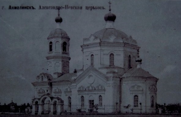
They did not change the name, and in all the papers of the tsarist administration the place appeared as Akmola, Akmolinsk. And this day can rightfully be considered the birthday of the future capital of Kazakhstan. Then the inhabitants of the fortress, there were only 313 people.
The construction of the fortress was complicated by the lack of building materials, they had to be brought from Petropavlovsk and Omsk. After the Shubin detachment completed the construction of the facilities necessary for the center, on August 22, 1832, the Akmola Order and the external district were officially opened.
The influential sultan of the Konyrkuldzha Kudaymendin region was elected as the senior sultan, who later began to enjoy the greatest authority and trust of the imperial colonial administration. The senior sultan, volost sultans, foremen, Kazakh assessors and biys took the oath on the Koran.
The holiday ended with the distribution of gifts, mass treats and horse racing-baig. The celebrations were accompanied by a baiga, a contest of wrestlers, aitys akyns. An artillery salute was made in 31 salvos from all the guns.
In 1840, a closed field fortification was built, which in the plan had the shape of a polyhedron with five towers. A central tower was built in the north of the bastion fortification. The lower part, equipped with a large embrasure for the gun, was made of adobe.
Today, this weapon is stored in the Presidential Center of Culture in Astana. The upper walls of the tower were built of pine logs, holes for shooting were built into them - small loopholes. From a military-strategic point of view, the bastion was favorably located and well defended.
On the south side, the fortification adjoined the Ishim River, in the west and north of it stretched swamps overgrown with reeds, in the east - the steppes. Over time with retired soldiers, small traders and craftsmen settled on the western side, they formed a group of buildings called "Slobodka".
Over time, people settled around the fortification, areas of the future Akmolinsk began to form. Until the Soviet days, old memorable names remained. The “fortress” was located within the modern Zheltoksan and Kenesary streets, the “Central Tower” stood at the gates of the modern H. Munaitpasov Central Stadium.
The sprawling fortification in 1845 became the Akmola stanitsa. Then, from the military line of the fortification of Orenburg-Petropavlovsk-Omsk, by lot, 100 Cossack families were resettled to Akmola. They formed the village village or the village "Cossack" under the eastern wall of the fortress.
In 1868, by the highest decree, the vast Akmola region was formed, consisting of five counties: Akmola, Kokchetav, Petropavlovsk, Omsk, and Atbasar. In accordance with the requirements of that time, the emblem of the region was approved.
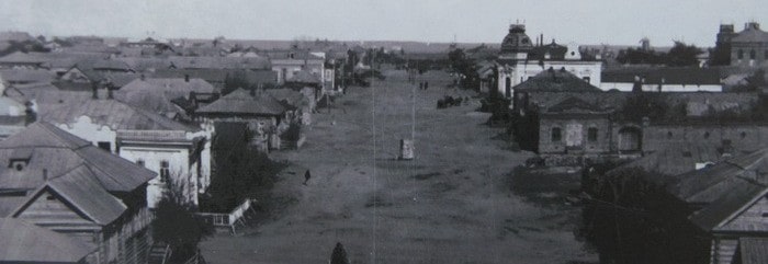
The inhabitants of Astana will never see the original coat of arms again: the storehouse of Heroldia, where it was located, was closed in 1917. In 1897, the city was not yet large: 9707 people lived in it. Only 7 residents of the city had higher education, and among them there was only one woman.
Literate people made up only 22.5% of the total number of Akmolins. These were the results of the first General Population Census of the Russian Empire, found by the oldest archivist of the capital Nikolai Ivanovich Baychikov.
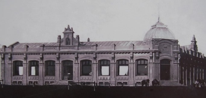
Gradually, the city began to be built up with stone houses, many of which are still preserved in the old center of the capital. Gradually, the urban education system began to expand. In 1898 in the region there were 3 city, 12 church and parish schools and several agricultural schools.
One of the most significant stages in the history of the northern provincial town began with the decision of the party and government of the USSR on the development of virgin and fallow lands. Young enthusiasts from all cities of the Soviet Union embarked on the idea of Nikita Khrushchev, General Secretary of the CPSU Central Committee.
On March 2, 1954, the first train arrived with volunteers from Alma-Ata, and on March 5 with Moscow virgin lands. According to historical data, only from 1953 to 1958, about 270 thousand people arrived in the Akmola region.
Until now, here, already in the young capital of Kazakhstan, the children and grandchildren of those first virgin lands live. Thanks to the development of virgin lands, the Akmola region has become one of the main granaries of the country and a major center of agricultural engineering.
During 1953 - 1956, 3.5 million hectares of virgin land were raised in the region. The city developed rapidly, and on December 26, 1960, a decree was issued on the formation of the Virgin Land. And since 1961 it was already called Tselinograd.
In pursuance of another idea ofNikita Khrushchev - the formation in Kazakhstan of the Tselinny Territory with the capital in Tselinograd - the Decree of the Council of Ministers of the USSR was adopted and a master plan for the development of the city was developed, as well as a plan for the reconstruction of old and the development of new buildings in the South-East direction.
On November 6, 1963, a telecentre began operating in Tselinograd. Then Tselinnikov Palace was opened, built according to the project of Latvian architects P.Yu. Vogels, O.N. Krauklis, D.K. Danneberg. It was designed for 2,355 seats.
By the scale and system of equipment at that time it was considered the second in the USSR after the Kremlin Palace of Congresses. In 1992, Tselinograd was renamed Akmola. And on July 6, 1994, a resolution was adopted by the Supreme Council of the Republic of Kazakhstan on the transfer of the capital from Almaty to Akmola.
In 1997, President of the Republic of Kazakhstan Nursultan Nazarbayev decided to transfer the capital from Almaty to Akmola. It was dictated by the favorable geopolitical location of the city in the center of the country at the intersection of the largest transport routes, the presence of the necessary transport and telecommunications infrastructure, and the availability of free land for the development of the capital.

Authority:
www.astana10.com