Вы здесь
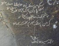
Petroglyphs of Kurama and Mogoltau mountains.

The Great Silk Road Tajikistan.
“The distance of time’s separation brings us remnants of memories so ancient that most are lost in the mists of illusion…”
A.J. Vosse.
Destinations and routes in Tajikistan.
Western Fergana (Kurama and Mogoltau Mounts) The far northern part of the republic is occupied by the Kuramin Ranges and the Mogoltau Mountain Massif that are part of the Western Tien-Shan.
The Kuramin Range is almost 170km long. The highest peak is Boboiob (3,768 m) in the north-eastern part of the range which recedes southwest towards the Dalverzin Plain. The southwestern part of the range is called Kara- Rock Art in Tajikistan 89 Mazar.
The Kuramin Range is distinguished for the rounded outline of its ridge line. Passes are low. An inclined plain unfolds at the foot of the range. A small isolated range – the Mogoltau Mountains – is south-west of the Kuramin Range at an altitude of 1,623m and stretches along the Syrdarya River for 40km.
The Mogoltau Range is the south-westernmost spur of Tien-Shan, isolated from the Kuramin Range by the Mirzorabat Depression (Panfilov 1984). The Fergana Basin that resembles an ellipse 350km long and up to 150km wide and the Fergana Depression are located between the Chatkal and Kuramin Ranges and the Mogoltau Mountains in the north-west, and the Turkestan and Alai Ranges in the south.
Closed by the Fergana Range in the north-east, the valley has a narrow passage only in the west known as the “Khodjent Gates” through which the Syr-Darya River flows out to the Golodnaya Steppe. Tajikistan occupies the western part of the Fergana Valley, relatively wide in the east and gradually narrowing westwards.
There it is mostly plain with most of the terrain consisting of the ancient terraces of the Syr-Darya River. The height of the Tajik part of the Fergana Basin ranges from 320m on the islands and floodplains of the Syr-Darya River up to 800 - 1,000m in the foothills surrounding the valley.
The Syr-Darya River divides the Fergana Valley into a right bank and a left bank. The right bank within Tajikistan stretches from the riverbank to the foot of the Kuramin Range and the Mogoltau Mountains with a height of 320 - 500m and lies between the left bank of the Syr-Darya and the foot of the Turkestan Range, gradually rising southward to an elevation of 1000m.
Predominant types of landscapes The Mogoltau Range is cut across from south to north by deep gorges that dry up in the summer. An important factor for carving petroglyphs in the mountains of Kurama and Mogoltau was the presence of springs.
Of Sites Rock art sites are well-known in the southern part of the Fergana Valley, where locations of petroglyphs are most numerous. In the 1970’s – 1980’s, Panfilov O.V. identified and recorded petroglyphs in Northern Tajikistan.
He discovered and researched relatively small concentrations of petroglyphs on Fergana Valley, such as at:
Petroglyphs “Bolshoy Kozyol” (or Large Goat) (18 images).
Petroglyphs Oktash (125).
Petroglyphs Dakhana I (95).
Petroglyphs Chashmasor (50).
Petroglyphs Kuruksai, Pangoz and Beshkotan.
According to Panfilov, by 1982 a total of 602 petroglyphs had been registered in the Mogoltau Mountains, their largest accumulations being in the gorges of Muzbet (127 images), Okkana (118), Bitiklik (102), and Shumliksai (72) (Panfilov 1984).
Chronologically, the petroglyphs of the Tajik part of the Fergana Valley cover a broad period, perhaps from the Bronze Age to the Early Iron Age to the present. The images are carved using the “animalistic style” indicative of early nomads, but they are few. Information about the Saka tribes, that lived in the area, exists in ancient sources and is confirmed by archaeological evidence.
Panfilov (1984) believed that Mogoltau was their peripheral area of residence or one of the areas for seasonal cattle work and hunting. Most images on rocks and stones appeared with the arrival and settling of the Kyrgyz and Uzbek tribes who lived there in the late XVIIth - XVIIIth centuries (Panfilov 1983).
Later petroglyphs, more numerous than ancient ones, are characterized by a simplified technique, a linear manner of portraying animals, mainly livestock. They differ by their light patina and their rough pecking by a stone. Archaeological context In addition to petroglyphs, there are habitation sites, tombs and fortresses of different periods.
In the Mogoltau mountains, ancient metallurgical mines were found. On the crest of the Kuramin Range are burial sites such as kurum and mughona. According to Ranov V.A. (1960: 121 - 142), the Kuruksaya engravings were left by mysterious tribes that erected their burial constructions in the Chatkal and Kuramin Ranges.
Litvinsky B.A. (1956, 1959) dates them from the IIIrd - IInd centuries BC to the VIth - VIIIth centuries AD. Recent Kuruksaya images have analogies with the Sheydana petroglyphs, a site also located in the Kuramin Range.
Authority:
Bobomullo S. Bobomulloev.
Photos by:
Surat Toymasov.


