


![]()
Вы здесь
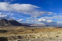
Glaciers of Vanch Range.
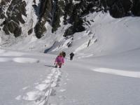
Night-time tour in Khorog.
“The long journey was hard,
And spring ice is difficult.
They want everyone to rest,
I want to go camping.”
Yuri Vizbor.
Trip from Dushanbe to Tavildara.
Parallel to the Darvaz Range, separated from it by the wide valley of the Vanch River, stretches the Vanch Range, whose average height is 4950 meters above sea level. The Darvaz Range is located in the Vanch, Rushan and partially Murghab regions of the Gorno-Badakhshan Autonomous Region of Tajikistan.
The northern slope of the ridge is long, divided by valleys, the upper reaches of which end with huge ancient valleys. Often they are elongated along the axis of the ridge, and their bottoms and slopes are occupied by glaciers.
The southern slope is steeper and shorter. There are 196 glaciers on the Vanzhsky Range with a total area of 148.6 square kilometers (118 glaciers with an area of 108.1 square kilometers on the northern slope and 78 glaciers with an area of 40.4 square kilometers on the southern).
The height of the firn line in the western part of the ridge is 3800 - 4000 meters above sea level on the northern slope and 4200 - 4400 meters above sea level on the southern. To the east, it rises to 4600 - 4700 meters above sea level.
All glaciers, with the exception of 6, are smaller than 3 square kilometers. 60% of their number are valley. There are glaciers with well-developed feeding areas, as well as glaciers of the Turkestan type with avalanche feeding.
Often, glaciers located in the upper valleys are elongated along the axis of the ridge and have asymmetric nutrition from the snowy northern slopes (glaciers in the upper reaches of the Gudzhovasay, Dustiroz, Sungat and others).
Most valley glaciers have flat moraines, below which are areas of dead ice. Caravan, valley and dangling glaciers are found throughout the ridge, but prevail in its lower western part. They are also characterized by avalanche feeding and buried ends.
The largest glaciers and more significant glaciation are in the eastern part of the ridge. 29 glaciers with an area of 43 square kilometers are located in the Dustiroz river basin, including the largest glacier of the Vanch Range - Left Dustiroz.
In the valley of the Sungat River, which is a high hanging trough with an extensive glacier in the upper reaches, there are 24 glaciers with an area of 18.6 square kilometers. Further to the west, river valleys become shorter, and on the slopes of the circuses in their upper reaches there are several small valley and caravan glaciers.
On the northern spur of the ridge below the confluence of the Abdukagor River into the Vanch River, there lies the cara-valley glacier Ravak (length 4.1 km, area 1.9 km square), the end of which crawled out on a steep estuary hanging threshold in 1967 valleys and broke in the form of ice-stone mudflow into the valley of the Vanch river.
In a matter of minutes, a cone of removal of ice, snow and stones with a volume of about 5 million cubic meters was formed, which for several hours suspended the course of the Vanch River. Melting of ice in the drift cone lasted several years (Dolgushin, Osipova. 1971).
The total area of glaciation of the Vanch Range is about 221 square kilometers.
The largest glaciers of the Vancha Range.
The Obvalov Glacier, with a length of 9.8 kilometers, an area of 5.5 square kilometers, located at an altitude of 3560 to 5660 meters above sea level, belongs to the basin of the Abdukagor River.
Cascade Glacier with a length of 9.5 kilometers, an area of 4.6 square kilometers, located at an altitude of 3560 to 5620 meters above sea level, belongs to the basin of the Abdukagor River.
The Right Sungat Glacier, with a length of 6.6 kilometers, an area of 4.2 square kilometers, is located at an altitude of 3800 to 5030 meters above sea level, belongs to the Darai-Sungat river basin.
The Privy Dustiroz glacier is 6.4 kilometers long, covering an area of 7.5 square kilometers, located at an altitude of 4060 to 5600 meters above sea level, and belongs to the right Dustiroz river basin.
5.9 km long Left Dustiroz Glacier, an area of 9.4 square kilometers, located at an altitude of 3880 to 5380 meters above sea level, belongs to the Devy Dustiroz River Basin.
Glacier 31 with a length of 6.1 kilometers, an area of 4.5 square kilometers, located at an altitude of 3800 to 5000 meters above sea level, belongs to the basin of the tributary of the Daray-Gujvosai River.
The Yuzhny Glacier with a length of 5.1 kilometers, an area of 2.4 square kilometers, located at an altitude of 3820 to 5000 meters above sea level, belongs to the basin of a tributary of the Dzhangoldara River.
The 5.0 km long Shaugado Glacier, an area of 7.5 square kilometers, is located at an altitude of 3800 to 5000 meters above sea level, belongs to the Shaugado River Basin.
The 2.6 km long Left Sungat Glacier, an area of 2.6 square kilometers, is located at an altitude of 4220 to 5100 meters above sea level, belongs to the Daray-Sungat River Basin.
Glacier 10 with a length of 4.6 kilometers, an area of 2.1 square kilometers, located at an altitude of 3260 to 4900 meters above sea level, belongs to the basin of the tributary of the Daray-Bosid River.
Glacier 152 with a length of 4.5 kilometers, an area of 4.5 square kilometers, located at an altitude of 3940 to 4930 meters above sea level, belongs to the basin of the tributary of the Dustiroz River.
The Chikhokh Glacier is 4.4 kilometers long, with an area of 2.2 square kilometers, located at an altitude of 3400 to 5000 meters above sea level, belongs to the Daray-Chikhokh River Basin.
The Ravak Glacier is 1.1 kilometers long, with an area of 1.9 square kilometers, located at an altitude of 3,500 to 5,130 meters above sea level, belongs to the Ravak River Basin.
Glacier 155 with a length of 4.0 kilometers, an area of 1.8 square kilometers, located at an altitude of 3780 to 5410 meters above sea level, belongs to the basin of the tributary of the Left Dustiroz River.
The Gujovasu Glacier is 3.9 kilometers long, with an area of 1.8 square kilometers, located at an altitude of 3,700 to 4,600 meters above sea level, and belongs to the Daray-Gujovasu River Basin.
The 3.8 km long Gujovasu Glacier, an area of 1.3 square kilometers, located at an altitude of 4250 to 5000 meters above sea level, belongs to the basin of the Daray-Gujovasu River tributary.
The Skrytyi Glacier with a length of 3.6 kilometers, an area of 2.7 square kilometers, located at an altitude of 4040 to 5200 meters above sea level, belongs to the basin of the Abdukagor River.
Glacier 240 with a length of 3.6 kilometers, an area of 0.9 square kilometers, located at an altitude of 3,500 to 4,800 meters above sea level, belongs to the Obirog river basin.
The 3.6-km Petruz Glacier, an area of 0.8 square kilometers, located at an altitude of 3860 to 5100 meters above sea level, belongs to the Daray-Petruz River Basin.
The Marble Glacier, with a length of 3.3 kilometers, an area of 1.3 square kilometers, is located at an altitude of 3500 to 5200 meters above sea level, belongs to the basin of the Abdukagor River.
Dolzhenko Glacier with a length of 3.2 kilometers, an area of 1.2 square kilometers, located at an altitude of 4240 to 5180 meters above sea level, belongs to the basin of the tributary of the Right Dustiroz River.
Authority:
"Glaciers." L.D. Dolgushin, G.B. Osipova. Series "Nature of the world." Moscow, the publishing house "Thought". 1989.
Photos by
Alexander Petrov.