


![]()
Вы здесь
History of Lake Sarez.

Ecological tours in the Pamirs.
“On the night of February 6-7, 1911, at 11:00 a.m., the people of the Pamir post (now the city of Murgab) were awakened by strong tremors; it seemed that the whole post was taken somewhere on a cart. The Orochorsky volost governor was equally impressed Kokan-bek, who wandered then on the eastern shore of Lake Kara-Kul"
"Pamir earthquake of 1911" VIGO member Colonel M.I. Cheykin.
The nature of the Murgab district.
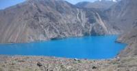
At the same time, 120 kilometers from the Pamir post in the Murgab valley, near the Tajik village of Usoi, as a result of a strong nine-magnitude earthquake, a huge slope of the mountain slope was rising, which was 2 - 2.5 kilometers above the valley.
On the Murghab River that night, a natural dam was formed by the elements up to 800 meters high, length across the valley up to 3.2 km and a volume of about 2.2 billion cubic kilometers. Kishlak Usoy with all the inhabitants (54 people) was completely buried by the rubble.
Three residents of Usoy survived by accident - Mirshalib Gurgaliyev, Namshit Karamshaev and Sulamat Karamkhudoev, who went on holiday to Sarez kishlak, survived an earthquake here, heard a crash and saw a dense curtain of dust standing over Usoy kishlak for several days.
Three days later, they managed to get to the place of the blockage and see a pile of rock fragments in the place of their native village. What was the total duration of the earthquake that was strongly felt at the Pamir post in Murghab?
According to the colonel M.I. Cheykina, “time must be counted as minutes, because one of the post officers who read a book in bed managed to get up, get dressed, leave, order to take the horses out of the stable, then return to his room again and make two cigarettes, just in case and then the vibrations of the soil stopped. Needless to say, hanging objects swung, even such as hunting rifles hanging on wide belts, gave a strong swing."
From the moment when the collapse occurred, our time is 56 years. During this time, on the Usoi Dam and Sarez Lake, despite the great difficulties of the route, especially in the period before the construction of the Pamir Highway, many brave researchers have visited.
The data they collected is the only source for judging the catastrophe that happened, the life of the Usoi Dam and Sarez Lake. In the Pamir and Tien Shan mountains there are many lakes formed from the collapse of the mountain masses, most of them are located high in the mountains, in places inaccessible to humans. Sarez Lake is one of the largest dammed lakes in the world, and Usoi Dam is the largest in our historical era.
Historical background of Lake Sarez. In 1883, the geologist D.L. Ivanov walked along the bottom of that part of the Murghaba Valley, where Sarez Lake was formed after 28 years, and gave a geological description of the area.
In 1889, the traveler B.L. Grombchevsky visited the village of Sarez and determined some elevations of the area. In 1900, the magnetologist B.V. Stankevich went to the same places and gave a description of the route.
From the records of these authors it follows that the section of the Murgab river from the mouth of the Lyangar river, further down the river is difficult to pass. The Murghab River flows in a deep gorge, clinging to one or the other bank. Kishlak Usoy sheltered on the right bank of the river, on a high terrace.
The trails went around this section along the left bank of the Murghab, to the side of it, and descended to the Murghab River somewhat lower than the village of Usoy. The descent represented three slopes separated by two plateaus; the upper slope is the coolest.
"Having descended to Murghab, we found ourselves as if at the bottom of a deep well: a small area on the left bank of Murghab is surrounded on three sides by very high and almost sheer cliffs, on the opposite bank almost the same steep cliffs rise."
In this place, in 1911, a collapse occurred, falling asleep to the village of Usoi. Two plateaus on the left bank mentioned by B.V. Stankevich, shown on the plan of this area, compiled by I.A. Preobrazhensky in 1915
Since 1911, the blockage and the lake have attracted the attention of many researchers, among whom were large geologists and scientists of our country.
In 1911, a topographer and surveyor, a member of VIGO, Colonel M.I. Cheykin, who worked at that time in the Pamirs, was apparently one of the first to talk about the disaster. In the same year, these places were visited by the German traveler Arved Schulz, who gave a brief description of the blockage.
In December, near the village of Sarez, the tops of trees still protruded from the water along the edges of the lake.
In 1913, engineer D.D. Bukinich made a tacheometric survey of the blockage and made the first assumptions about the possibility of a breakthrough. In 1913 and 1914, the head of the Pamir detachment, Lieutenant Colonel of the General Staff G.A. Shpilko made a survey of the lake and the blockage, gave a longitudinal profile along the bottom of the valley, discovered (in 1914) springs on the body of the blockage.
He invited a local resident Niyaz Kabulov to monitor the level of the lake through 58 pyramids made of stone at a distance of one fathom vertically. According to G.A. Shpilko, “Sarez Lake is not able to break through or overturn the blockage. The descent of the lake will begin with the seepage of water, which by slowly eroding its bed will turn into a more or less calm flow through the blockage. ” This forecast G.A. Shpilko made excuses.
In 1915, I.A. Preobrazhensky for 20 days in the dam made a geological survey, investigated the composition of the dam, prepared two topographic plans of the area before the dam and after, determined the volume and explained the reasons for the collapse prepared by water erosion.
He believed that a little push was enough for the whole mass to slip on an inclined surface. The depth of the lake at that time reached 353 m. The total flow rate of the springs I. A. Preobrazhensky estimated at 2 meters per second. Regarding the danger of breaking through the blockage, he supported the opinion of G.A. Shpilko.
In 1923, N.L. Korzhenevsky visited the lake, noted an increase in the level, and considered the Murgab river below the dam almost restored.
In 1925, the topographer V.S. Kolesnikov was first discovered by a ravine (canyon), along which a river was already flowing with a water discharge close to that of Murghab.
In 1926, Professor O.K. Lange led an expedition consisting of A.N. Volkova, N.F. Teikhman and T.M. Shcheulova, who took a photographic and theodolite survey of the obstruction and performed a number of works on the lake and the rivers flowing into it. It was believed that filtration in the form of karst type flows would entail deformation of the blockage and the advance of the canyon towards the lake. It was further stated that for final decisions, the available data are insufficient and systematic research is required.
In 1929 - 1934, Sarez Lake and the block were visited by members of the Tajik-Pamir expedition geologists G.L. Yudin, Zimmerman and P.P. Chuenko. They compiled schematic geological maps of the basin and shores of Lake Sarez. In 1932, engineer N.A. Karaulov investigated the issue of energy use of Lake Sarez. He believed that the obstruction does not pose a direct threat to the downstream valleys, and recommended that he be systematically monitored.
In 1934, V.A. Afanasyev, on the initiative of the NK RKI of the USSR, organized an expedition, which included T.M. Shcheulov, L.V. Dunin-Barkovsky, A.I. Tikhomirov and others. The expedition processed the photo and theodolite survey of the dam, made in 1926, and made a new same survey of the lake, determined the speed of the flow through the dam (they were up to 2.7 meters per second. It was found that the advance of the canyon’s beginning had almost stopped , its bottom deepened somewhat and two new canyons appeared, connecting slightly lower with the main one.
The discharge of the Murgaba river increased to 80 cubic meters per second, and the lake level rose above the maximum (1926) by 7.7 m. The expedition members agreed with the opinion G.A. Pilko IA Preobrazhensky and the stability of the dam.
In 1938, a hydrometeorological station was opened in the Irkht Bay of Lake Sarez; hydrologist I.E. Gorshenin in 1943 surveyed the lake. In 1939, the hydrologist A.A. The soldiers measured the speed of water filtration and found it equal to 1.73 m / s - less than the measurements in 1934
In 1946, the head of the meteorological station Irkht V.V. Akulov carried out geological and geomorphological mapping of the shores of the lakes of Sarez and Shadaukul, and also summarized all the materials available at that time on the blockage and lake.
In the same year, the lake was visited by V.I. Racek, who, on the basis of aerial photographs and his own photographs, believed that the collapse met a ridge on its way that served as the left bank of the Shadaudar River and brought it into the river, resulting in Lake Shadaukul. IN AND. Racek considered the blockage solid and did not allow the possibility of a catastrophic breakthrough by the waters of the lake.
In 1956, the MISI expedition named after Kuibyshev led by O. F. Vasiliev with the participation of engineers A.N. Marchuk, E.N. Elizarova, P.M. Wissing and others examined the blockage and the origins of Murghab.
Using a tacheometric course with leveling from the edge of Lake Sarez to the beginning of the canyon, the expedition established the shortest distance between the lake and the exit of the first springs - about 1.5 km and the difference in their levels - 146 m. Vasiliev believed that only new large landslides in the same place or in the lake could be a danger. Filtration costs stabilized and their fluctuations follow fluctuations in lake level.
In 1957, hydrologists R.I. Selivanov and V.I. Andreev performed a leveling move through the lower part of the blockage. The formation of a through valley, in their opinion, will stretch for many hundreds of years, the development of the lake in the flowing will proceed calmly, evolutionarily.
V.N. Reizvikh, who repeatedly visited the Usoi Dam and studied the elements of the water balance of Lake Sarez, developed this balance in 1959 using a 20-year observation cycle. In the discussion of issues that arose around the Usoi Dam and Sarez Lake, many prominent scientists and researchers took part - V.N. Weber, L.S. Berg, K.I. Bogdanovich, D.I. Mushketov, D.D. Bukinich, D.V. Nalivkin, I.L. Korzhenevsky, O.K. Lange, N.G. Malitsky, B. B. Golitsyn, N.A. Karaulov, L.A. Molchanov.
Geologists distinguish two types of ridges in the Pamirs: orographic, formed as a result of erosion, and tectonic. The former are elongated in the meridional direction (Zulumart, Academies of Sciences, Sarykol), the latter in the latitudinal direction (Zaalaysky, Rushansky, Yazgulemsky) and the Western Pamir are divided by deep river valleys, over which ridges and peaks rise 3000 - 4000 meters at an absolute elevation above the level Sea 5000 - 6000 meters above sea level.
The highest peaks (Communism Peak - 7495, Garmo - 6595. Pathor - 6080 and Karl Marx - 6726 m) are located approximately along the border of the Western and Eastern Pamirs. The Pyanj River, starting from the confluence of the Pamir and Vakhan-Darya rivers, to reaching the valley near Chubek, paved its way through the highest mountain ranges (Vakhansky, Shugnansky, Rushansky, Yazgulemsky, Vanzhsky, Darvaz).
On this site, its main right tributaries flow into Pyanj: Gunt with Shahdara (near the city of Khorog), Bartang (near the city of Rushan), Yazgul and Vanch; the most watery of them is Bartang. This name he received earlier after the confluence of the Murgab and Kudara rivers, now Bartang is called the river flowing from Lake Sarez through the Usoi Dam.
The Murghab river flows from the Chokmoktikul lakes on the territory of Afghanistan and flows under the name of Aksu to the Pamir post, then, before merging with Kudara, it bears the Tajik name Murghab. Kudara is formed by the confluence of two rivers - Tanymas and Kukuybel, feeding on glaciers of the ridges of the Academy of Sciences, Muzkol and their spurs.
The Bartang River flows in a deep narrow gorge formed from the north by the Yazgul and Muzkol ridges (after the confluence of the Kudara River) and their spurs, from the south by the Rushan Ridge, its extension to Bazardar and their spurs.
The Bartang Gorge is winding, with steep slopes, rocky in its upper parts, and below - covered with stone talus. In places, at the confluence of the rivers, the gorge slightly widens. There are small Tajik villages, crops, gardens.
Above Kudara’s confluence along the Murghab, the last Tajik villages - Usoy, Sarez and Irkht - disappeared during the disaster in 1911. This is the area of extreme limits of agriculture. Above the valley of Murghab, like all the valleys of the Eastern Pamirs, it is deserted, rocky, with sparse vegetation.
Sarez Lake stretched along the southern slope of the western part of the Muzkol Range. This slope has a small width of 5-6 kilometers and descends rather steeply to the lake. The maximum height of the ridge reaches 5800 - 5900 meters above sea level.
Six large glaciers descend to the Sarez lake from the Muzkol ridge, similar to the glaciers of the Sarez ridge located on the southern side of the lake. These glaciers, different from the glaciers of the Western and Eastern Pamirs, have relatively small feeding areas, 200 – 300 meters wide, 2 – 3 kilometers long, then leaving under the thickness of continuous gravel.
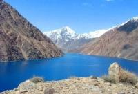
Sarez Lake. The level mark of Lake Sarez (its name is taken from a flooded village) 3222 meters above sea level (August 1946). Lake Shadaukul has the same mark. This is due to the fact that the lakes communicate with each other by water, filtered through a stone bridge separating them.
The length of the lake along the axis is 61 kilometers, the width in Mardzhanay Bay is 3.38 km and slightly less at the blockage, in other places - 1 - 2 km. Its greatest depth at the obstruction is 505 meters. The area of the lake is 88 km, the total length of the coastline is 175 km.
There is only one island on the lake (against the bay of Marjanay), 200 m from the northern shore, measuring 400x150 m. The volume of water in the lake is 17 km. Lake Shadaukul has a length of 3 km, the largest width of 0.8 km, an area of 2.2 km², the greatest depth of 240 m.
Authority:
Academician V.V. Poslavsky. “About one disaster in the Pamirs. (History of Lake Sarez). Hydraulic engineering and land reclamation. No. 3. Moscow. 1968. http://www.nikzdaru.com/