Вы здесь
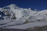
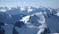
Glaciers of Sarykol Range.


Make a journey in Tajikistan.
“What is that feeling when you're driving away from people and they recede on the plain till you see their specks dispersing? - it's the too-huge world vaulting us, and it's good-bye. But we lean forward to the next crazy venture beneath the skies”
Jack Kerouac, «On the Road».
Short trip in Tajikistan.
The Sarykol Range is a chain of gentle, slightly dissected mountains that stretches from north to south from the Markansu River Valley to the spurs of the Hindu Kush. The Sarykol Range is located in the Eastern Pamirs, in the Murgab district of the Gorno-Badakhshan Autonomous Region of Tajikistan.
The height of the ridge is from 4,500 to 5,800 meters above sea level, the average height of the firn line is 5,250 meters above sea level. Glaciers are only on the highest parts of the ridge. Sarykol ridge bordering with the People's Republic of China.
On the western slope of the ridge, in Tajikistan, 240 glaciers an area of 143.9 square kilometers. Valley glaciers prevail (33% of the number and 58% of the area). These are small glaciers (the average area of the valley glacier is 1.4 kilometers square), characterized by a relatively gentle fall and a gradual transition to firn fields occupying flat slopes and watersheds.
They lie in the upper reaches of the deep, north-oriented valleys. Slope glaciers are also numerous (33% of the number and 21% of the area). The area of the average slope glacier is 0.6 kilometers square. These glaciers cover the gentle slopes of shallow valleys, descending from the ridge to the thalweg.
Caravan glaciers, not typical for the Eastern Pamirs, are found on the Sarykol Range only in its southern part in the Aksai river basin. Due to the dry climate and the high intensity of solar radiation at low temperatures on the glaciers in some years, vast fields of vertically pointed, under the influence of the sun, glaciers form.
Within the Sarykol Range, several foci of glaciation are distinguished. In the northern part of the ridge, where it rises above 5800 meters above sea level, there is the peak of the Red Commanders, 5811 meters above sea level, 47 glaciers with a total area of 43.3 kilometers square, including 29 glaciers with an area of 12.2 kilometers square in the river basin Marcansu, the rest - in the basin of Lake Karakul.
The company line runs at an altitude of 5300 - 5400 meters above sea level. Here, in the upper reaches of the shaded valleys, there are several valley glaciers with an area of up to 6.2 square kilometers. The ends of glaciers go down to 4500 - 4800 meters above sea level. In this region, at the peak of the Red Commanders, there is the only flat-top glacier in the Pamirs (2.8 km square).
The second glaciation center is located southeast of Lake Karakul, in the upper reaches of the Karaart River, where a section of the ridge is more than 5800 meters above sea level, has a latitudinal direction. Easily collapsing rocks on the slopes contribute to the fact that glaciers for a considerable extent are covered by moraine.
Slope glaciers are widely represented with clean, clearly defined, as if cut off edges. The largest slope glacier - Buz-Dzhilga (area 4.2 square kilometers) - occupies the entire flat rear slope of the valley of the same name. In this section of the Sarykol Range 104 glaciers with a total area of 55.4 square kilometers.
On the northern slope of the Kyzyldzhik ridge, to the south, a chain of shallow slope glaciers stretches along its ridge (20 glaciers with an area of 3.7 square kilometers). In the extreme south of the Sarykol Range there are glaciers in areas rising above 5100 meters above sea level.
Firm line passes in this area slightly lower than on the rest of the Sarykol ridge (5000 m), since the influence of the Indian monsoon is affected here. In total there are 69 glaciers with a total area of 41.8 square kilometers.
Authority:
"Glaciers." L.D. Dolgushin, G.B. Osipova. Series "Nature of the world." Moscow, the publishing house "Thought". 1989.


