


![]()
Вы здесь
Glaciers of Hissar Range.
Camping trip in Uzbekistan.
“We leave something of ourselves behind when we leave a place, we stay there, even though we go away. And there are things in us that we can find again only by going back there”
Pascal Mercier. «Night Train to Lisbon».
Long-distance hiking in Uzbekistan.
The Hissar Range branches off from the Zeravshan Range in the Gulbas mountain junction and stretches parallel to it, over a distance of more than 150 kilometers. In its middle part, it goes around Lake Iskanderkul, forming an arc curved to the south, and then turns north again and joins the Zeravshan Range, forming the Ganza-Chimtarginsky Massif (Fann Mountains).
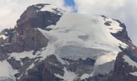
Average the height of the Hissar Range is 3990 meters above sea level, in the eastern part up to 5000 meters above sea level. In total, there are 1,048 glaciers on the Gissar Range with a total area of 354.1 square kilometers.
Despite significant moisture, glaciation is an island character, represented mainly by small glaciers. In the western part it’s mainly corrie and hanging glaciers located in the narrow ridge zone of the ridge and its spurs.
To the east, with the rise of mountains, glaciers become somewhat larger, and the proportion of valley glaciers increases there. The southern slope of the Hissar Range is strongly dissected. It is longer and to the north, and within its limits, numerous spurs, which are the watersheds of the Kashkadarya, Surkhandarya, Kafirnigan and Sorbog rivers, extend in the southern, southwestern and western directions. The valleys of these rivers are open to the western and southwestern moisture-bearing air currents, and precipitation in the central zone of the mountains falls to 2000 mm per year.
On the southern slope of the Gissar Range, there are 624 glaciers with a total area of 209.9 square kilometers. Glaciers are distributed among river basins as follows. There are 58 glaciers in the Kashkadarya river basin with an area of 20.3 square kilometers.
These are mainly small caravan glaciers. The average height of the ends of the glaciers is 3760 meters above the level of Moi, the height of the firn line is 3700 - 4100 meters above sea level. There are 239 glaciers in the Surkhandarya river basin with an area of 83.6 square kilometers.
The largest glacier has an area of 3.0 square kilometers. The average height of the ends of the glaciers is 3725 meters above sea level. In the Kafirnigan river basin, 327 glaciers with an area of 106.0 square kilometers.
The character of glaciation here is determined by caravan and valley glaciers, which account for almost 36% of the area. The average height of the ends of the glaciers is 3650 meters above sea level, the firn line is 3370 meters above sea level.
In the upper reaches of the Garif River, which forms the Sorbog River, in the eastern part of the ridge, there are 22 glaciers with an area of 20.2 square kilometers. On the northern slope of the Gissar Range, there are 424 glaciers with an area of 144.2 square kilometers.
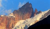
The bulk of the ice and hanging glaciers are not more than 0.5 square kilometers. On the Gansa-Chimtarginsky mountain junction (Fann mountains) with the highest peak Chimtarga 5480 meters high above sea level and Hansa 5300 meters high above sea level, there are 160 glaciers with a total area of 38.9 kilometers square.
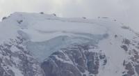
About half of the area is in plain valley glaciers, which make up about 25% of the total number of glaciers. Largest Fansky Glacier mountains - Imat caravan valley glacier (3.2 km long, 3.8 km square) on the northern slope in the Pasrut River Basin (Zerafshan River). It is considered typical of the western part of Hissar-Alai. The feeding area of this glacier is located in an oblong closed circus with a length of more than 1.5 kilometers and a width of 1.2 kilometers.
The snout of a glacier with a width of up to 350 meters with two ice falls down to an altitude of 3000 meters above sea level. On this glacier in 1964 - 1968 and 1970 stationary studies were conducted. The thickness of the ice below the ice falls to 100 meters, and in the area of ice falls - 70 - 80 meters.
The average melting in the tongue is 57 - 67 mm per day. The average speed of ice movement is about 14 centimeters per day (Lesnik. 1969).
The total area of glaciation of the Hissar Range is about 200 square kilometers.
The largest glaciers of the Gissar Range.
The Kaniz Glacier, with a length of 5.3 kilometers, an area of 7.9 square kilometers, is located at an altitude of 3220 to 4480 meters above sea level, belongs to the Kafirnigan river basin.
Loylyakul glacier, with a length of 3.4 kilometers, an area of 2.9 square kilometers, located at an altitude of 3480 to 3900 meters above sea level, belongs to the Sardai-Mien, Kafirnigan river basin.
The Khanaka Glacier, with a length of 3.2 kilometers, an area of 2.5 square kilometers, located at an altitude of 3160 to 3960 meters above sea level, belongs to the Kafirnigan river basin.
Khanakasu Glacier, with a length of 3.1 kilometers, an area of 2.6 square kilometers, located at an altitude of 3270 to 4000 meters above sea level, belongs to the Kashkadarya river basin.
The Batyrbay glacier, 2.4 km long, with an area of 1.6 square kilometers, is located at an altitude of 3280 to 3500 meters above sea level, belongs to the Sardai-Miena, Kashkadarya river basin.
The 1.7 km long Naushchur glacier, an area of 0.6 square kilometers, is located at an altitude of 3,500 to 3,720 meters above sea level, belongs to the Kashkadarya river basin.
Authority:
"Glaciers." L.D. Dolgushin, G.B. Osipova. Series "Nature of the world." Moscow, the publishing house "Thought". 1989.